Cafe nearby Mil Seiscientos
Argentina
Cafe nearby Mil Seiscientos
Mil Seiscientos
1600, Rojas, C1416, Comuna 15, Buenos Aires, AR Argentina
contacts phone
:
+54 11 4583-8154
Latitude:
-34.6036763
, Longitude:
-58.4506379
larger map & directions
read more
nearest Cafe
181 m
Eventos liza
C1414CEE, Avenida Doctor Honorio Pueyrredón 1515
Cafe
read more
280 m
Spot Luis viale
Avenida San Martín 1521
Cafe
read more
316 m
Morenú
Avenida San Martín 1518
Cafe
read more
330 m
La Princesa Café
C1416CRR, Avenida San Martín 1650
Cafe
read more
502 m
Vittoriano Café
Coronel Apolinario Figueroa 300
Cafe
read more
572 m
Tienda de Café
Avenida Doctor Honorio Pueyrredón 1121
Cafe
read more
648 m
Leños
Avenida Juan Bautista Justo 3911
Cafe
read more
705 m
Havanna
Avenida San Martín 2182
Cafe
read more
754 m
Parada Del 24
Coronel Apolinario Figueroa 100, 2, C1414EDB
Cafe
read more
791 m
Anita Cafe
Argentina
Cafe
read more
800 m
Irupé
Avenida San Martín 2244
Cafe
read more
892 m
Kiosco Villa Mitre
Avenida Juan Bautista Justo 4164
Cafe
read more
900 m
Cafetin Bs As
Avenida Raúl Scalabrini Ortíz 100
Cafe
read more
938 m
Mundo perro
Padilla 409
Cafe
read more
1.006 km
Caffe Macchiato
Nicasio Oroño 2451
Cafe
read more
1.012 km
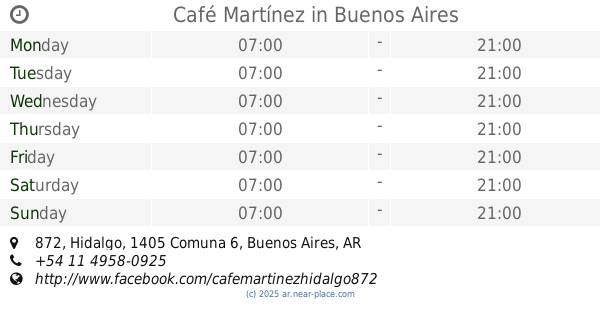
Café Martínez
Hidalgo 872
Cafe
read more
1.029 km
Coffee shop
Avenida Díaz Vélez 5298
Cafe
read more
1.029 km
Bar Alexis
Malabia 334
Cafe
read more
1.064 km
Bonafide
Malabia 364
Cafe
read more
1.078 km
Café Bonafide
5444, Avenida Corrientes
Cafe
read more
1.081 km
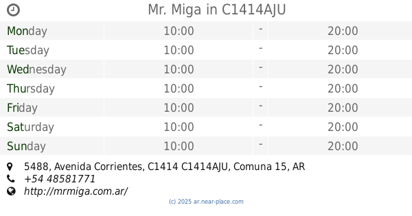
Mr. Miga
Avenida Corrientes 5488, C1414AJU
Cafe
read more
1.131 km
Starbucks
Avenida Corrientes 5347
Cafe
read more
1.149 km
Havanna
Hidalgo
Cafe
read more
1.153 km
La Blonde
C1405BAR, Avenida Doctor Honorio Pueyrredón 734
Cafe
read more
1.382 km
Pizzeria Willie
Juan Ramírez de Velasco, Serrano y
Cafe
read more
📑
all categories
Accounting
Administrative area level 1
Administrative area level 2
Airport
Amusement park
Aquarium
Art gallery
Atm
Bakery
Bank
Bar
Beauty salon
Bicycle store
Book store
Bowling alley
Bus station
Cafe
Campground
Car dealer
Car rental
Car repair
Car wash
Casino
Cemetery
Church
City hall
Clothing store
Colloquial area
Convenience store
Country
Courthouse
Dentist
Department store
Doctor
Electrician
Electronics store
Embassy
Establishment
Finance
Fire station
Florist
Food
Funeral home
Furniture store
Gas station
General contractor
Grocery or supermarket
Gym
Hair care
Hardware store
Health
Hindu Temple
Home goods store
Hospital
Insurance agency
Intersection
Jewelry store
Laundry
Lawyer
Library
Light rail station
Liquor store
Local government office
Locality
Locksmith
Lodging
Meal delivery
Meal takeaway
Mosque
Movie rental
Movie theater
Moving company
Museum
Natural feature
Neighborhood
Night club
Painter
Park
Parking
Pet store
Pharmacy
Physiotherapist
Place of worship
Plumber
Point of interest
Police
Political
Post office
Premise
Real estate agency
Restaurant
Roofing contractor
Route
Rv park, camping
School
Shoe store
Shopping mall
Spa
Stadium
Storage
Store
Subpremise
Subway station
Supermarket
Synagogue
Taxi stand
Train station
Transit station
Travel agency
University
Veterinary care
Zoo
sublocality level 1
sublocality level 3
↑