Cafe nearby Mossuti
Coronavirus disease (COVID-19) Situation
confirmed cases
10128845
deaths
130841
Argentina
Cafe nearby Mossuti
Mossuti
1047, Paraná, C1018, Comuna 2, Buenos Aires, AR Argentinien
contacts phone
:
+54
Latitude:
-34.596405
, Longitude:
-58.3882904
larger map & directions
read more
nearest Cafe
102 m
Rondo Cafe, Tienda de cafe
Uruguay 1048 C1016ACB
Cafe
read more
203 m
Café Cabrales - Tienda Recoleta
Arenales 1558
Cafe
Food
Point of interest
Establishment
read more
230 m
El Patio Café & Estudio Bar
Retiro
Cafe
read more
343 m
Bonafide
Talcahuano 862, AAR
Cafe
Point of interest
Food
Establishment
read more
373 m
Import Coffee Company
Libertad 1150
Cafe
read more
503 m
Havanna
Uruguay 695
Cafe
read more
590 m
Café Sibarita
Cerrito 814
Cafe
read more
626 m
Croque Madame
Avenida Callao 1569
Cafe
read more
627 m
Café Martínez
Arenales 1913
Cafe
read more
628 m
Angelica
Riobamba 815
Cafe
read more
697 m
Cafe Door's
Tucumán 1702
Cafe
read more
702 m
Starbucks
Avenida Santa Fe 1999
Cafe
read more
739 m
Café Tribunales
Uruguay 485
Cafe
read more
743 m
Carrá
Lavalle 1609
Cafe
read more
881 m
Cachafaz Café
C1128ACC, Vicente López 1969
Cafe
read more
907 m
Cachafaz Café
Uriburu 1789
Cafe
read more
908 m
Le Gobet Patisserie
Juncal 846, C1062ABF
Cafe
read more
955 m
La Molinera
Avenida Santa Fe 2202
Cafe
read more
975 m
La Biela
Presidente Manuel Quintana 596
Cafe
Food
Point of interest
Establishment
read more
990 m
The Panera Rosa
C1129ABB, Avenida Presidente Manuel Quintana 595
Cafe
read more
1.003 km
Havanna
Riobamba 401, C1025ABI
Cafe
read more
1.017 km
Dos cortados 2
Av. Gral. Paz 10880 local B
Cafe
read more
1.035 km
Petty Bar
Lavalle 901
Cafe
read more
1.09 km
Gaudi
Esmeralda 578
Cafe
read more
1.279 km
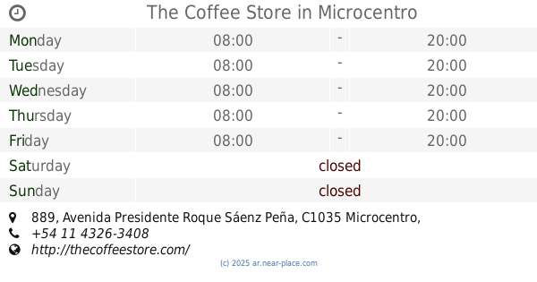
The Coffee Store
Avenida Presidente Roque Sáenz Peña 889, Microcentro
Cafe
read more
📑
all categories
Accounting
Administrative area level 1
Administrative area level 2
Airport
Amusement park
Aquarium
Art gallery
Atm
Bakery
Bank
Bar
Beauty salon
Bicycle store
Book store
Bowling alley
Bus station
Cafe
Campground
Car dealer
Car rental
Car repair
Car wash
Casino
Cemetery
Church
City hall
Clothing store
Colloquial area
Convenience store
Country
Courthouse
Dentist
Department store
Doctor
Electrician
Electronics store
Embassy
Establishment
Finance
Fire station
Florist
Food
Funeral home
Furniture store
Gas station
General contractor
Grocery or supermarket
Gym
Hair care
Hardware store
Health
Hindu Temple
Home goods store
Hospital
Insurance agency
Intersection
Jewelry store
Laundry
Lawyer
Library
Light rail station
Liquor store
Local government office
Locality
Locksmith
Lodging
Meal delivery
Meal takeaway
Mosque
Movie rental
Movie theater
Moving company
Museum
Natural feature
Neighborhood
Night club
Painter
Park
Parking
Pet store
Pharmacy
Physiotherapist
Place of worship
Plumber
Point of interest
Police
Political
Post office
Premise
Real estate agency
Restaurant
Roofing contractor
Route
Rv park, camping
School
Shoe store
Shopping mall
Spa
Stadium
Storage
Store
Subpremise
Subway station
Supermarket
Synagogue
Taxi stand
Train station
Transit station
Travel agency
University
Veterinary care
Zoo
sublocality level 1
sublocality level 3
↑