Cafe nearby Whoopies
Argentina
Cafe nearby Whoopies
Whoopies
Juncal 3000-2902, C1425AYL, C1425AYL CABA, Argentina
contacts phone
:
+54
Latitude:
-34.5878349
, Longitude:
-58.4066892
larger map & directions
read more
nearest Cafe
197 m
Delicity
Juncal 3100
Cafe
read more
292 m
Bonafide
Beruti 2951
Cafe
read more
333 m
Alma Café
Galería Alto Palermo Shopping, Avenida Santa Fe 3255
Cafe
read more
337 m
Havanna
Alto Palermo Shopping Center, Avenida Santa Fe 3253
Cafe
read more
506 m
Los Molinos Confitería
C1425ASG, Avenida General Las Heras 2991
Cafe
read more
520 m
Pastelería El Progreso
Avenida Santa Fe 2820
Cafe
read more
617 m
Havanna
Avenida Pueyrredón 1802
Cafe
read more
644 m
Nucha
Vidt 2000, Buenos Aires
Cafe
read more
654 m
Caren
Avenida Pueyrredón 1881
Cafe
read more
656 m
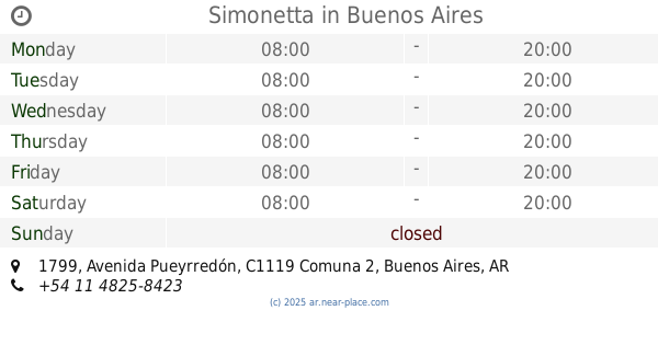
Simonetta
Avenida Pueyrredón 1799
Cafe
read more
711 m
Heladeria Y Cafetería Palermo
Julián Álvarez 2492
Cafe
read more
746 m
La Tolva
C1425BGO, Avenida Santa Fe 2602
Cafe
read more
764 m
Café Martínez
Bulnes 1790
Cafe
read more
768 m
Aroma Café
Avenida Santa Fe 2551
Cafe
read more
787 m
El Club del Té | Academia de té, catas y eventos corporativos
AOA, José León Pagano 2653
Cafe
read more
810 m
J.A.Roca
Charcas 2669
Cafe
read more
832 m
Café HAUS
Avenida Santa Fe 3618
Cafe
read more
851 m
Via Vecchia
Avenida General Las Heras 3800
Cafe
read more
856 m
Emilyn bakery & coffee
Charcas 2599
Cafe
read more
1.003 km
Coffe
Soler 3602, C1425BWI
Cafe
read more
1.006 km
Café Martínez
Avenida Pueyrredón 1202
Cafe
read more
1.044 km
Coco Café
C1425APP, Cabello 3794, Buenos Aires
Cafe
read more
1.058 km
Coffe Sweet & Deli
C1425BWO, Soler 3945
Cafe
read more
1.126 km
La Molinera
Avenida Santa Fe 2202
Cafe
read more
1.313 km
Starbucks
Avenida Santa Fe 1999
Cafe
read more
📑
all categories
Accounting
Administrative area level 1
Administrative area level 2
Airport
Amusement park
Aquarium
Art gallery
Atm
Bakery
Bank
Bar
Beauty salon
Bicycle store
Book store
Bowling alley
Bus station
Cafe
Campground
Car dealer
Car rental
Car repair
Car wash
Casino
Cemetery
Church
City hall
Clothing store
Colloquial area
Convenience store
Country
Courthouse
Dentist
Department store
Doctor
Electrician
Electronics store
Embassy
Establishment
Finance
Fire station
Florist
Food
Funeral home
Furniture store
Gas station
General contractor
Grocery or supermarket
Gym
Hair care
Hardware store
Health
Hindu Temple
Home goods store
Hospital
Insurance agency
Intersection
Jewelry store
Laundry
Lawyer
Library
Light rail station
Liquor store
Local government office
Locality
Locksmith
Lodging
Meal delivery
Meal takeaway
Mosque
Movie rental
Movie theater
Moving company
Museum
Natural feature
Neighborhood
Night club
Painter
Park
Parking
Pet store
Pharmacy
Physiotherapist
Place of worship
Plumber
Point of interest
Police
Political
Post office
Premise
Real estate agency
Restaurant
Roofing contractor
Route
Rv park, camping
School
Shoe store
Shopping mall
Spa
Stadium
Storage
Store
Subpremise
Subway station
Supermarket
Synagogue
Taxi stand
Train station
Transit station
Travel agency
University
Veterinary care
Zoo
sublocality level 1
sublocality level 3
↑