Clothing store nearby Vanellope
Argentina
Clothing store nearby Vanellope
Vanellope
4640, Núñez, Comuna 12, Buenos Aires, AR Argentina
contacts phone
:
+54
Latitude:
-34.5610525
, Longitude:
-58.4875771
larger map & directions
read more
nearest Clothing store
251 m
Epifanio Velasco E Hijos
Donado 3552
Clothing store
read more
566 m
Only Girls
Quesada 4562
Clothing store
read more
589 m
Compra
José Pascual Tamborini 5001-5099, C1431AGI
Clothing store
read more
679 m
Lenceria
Avenida Doctor Ricardo Balbín 4156, C1430AAZ
Clothing store
read more
692 m
Maruja feria americana
Mariano Acha 4092
Clothing store
read more
698 m
Scorlabe
Tronador 3820
Clothing store
read more
715 m
Pigmento Perfumerías
Avenida Doctor Ricardo Balbín 3955, Buenos Aires
Clothing store
read more
720 m
Go Lola!
Holmberg 4011
Clothing store
read more
721 m
Lidia Amaya
Avenida Doctor Ricardo Balbín 3870
Clothing store
read more
744 m
Duendes Urbanos
Estomba 3786
Clothing store
read more
756 m
Olegario
Avenida Doctor Ricardo Balbín 3883
Clothing store
read more
762 m
Las Chicas del Parque
Avenida Doctor Ricardo Balbín 3845
Clothing store
read more
771 m
F.G. Deportes
Avenida Doctor Ricardo Balbín 3805
Clothing store
read more
824 m
Sentido
Díaz Colodrero 3099
Clothing store
read more
868 m
Overlock
Manzanares 3899
Clothing store
read more
983 m
Foxboro
Olof Palme 4256
Clothing store
read more
1.016 km
AQUI LA TULY Pantalones reforzados
C1430EAE, Miller 4403
Clothing store
read more
1.019 km
Club de Disfraces Juacla
Vilela 3902
Clothing store
read more
1.045 km
Zona Aire. Ropa de circo.
Mariano Acha 2669, Ciudad autonoma
Clothing store
read more
1.071 km
María Liz
José Pascual Tamborini 5437
Clothing store
read more
1.094 km
Mariu
Ramallo 4696
Clothing store
read more
1.101 km
Mary
Ramallo 4689
Clothing store
read more
1.103 km
Romanaca Srl
5472, AGR, José Pascual Tamborini C1431AGR, Buenos Aires
Clothing store
read more
1.122 km
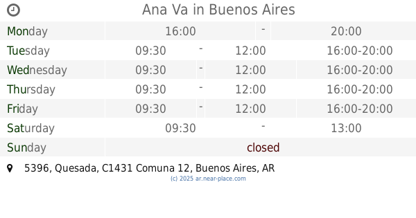
Ana Va
Quesada 5396
Clothing store
read more
1.241 km
Budada
Arias 4975
Clothing store
read more
📑
all categories
Accounting
Administrative area level 1
Administrative area level 2
Airport
Amusement park
Aquarium
Art gallery
Atm
Bakery
Bank
Bar
Beauty salon
Bicycle store
Book store
Bowling alley
Bus station
Cafe
Campground
Car dealer
Car rental
Car repair
Car wash
Casino
Cemetery
Church
City hall
Clothing store
Colloquial area
Convenience store
Country
Courthouse
Dentist
Department store
Doctor
Electrician
Electronics store
Embassy
Establishment
Finance
Fire station
Florist
Food
Funeral home
Furniture store
Gas station
General contractor
Grocery or supermarket
Gym
Hair care
Hardware store
Health
Hindu Temple
Home goods store
Hospital
Insurance agency
Intersection
Jewelry store
Laundry
Lawyer
Library
Light rail station
Liquor store
Local government office
Locality
Locksmith
Lodging
Meal delivery
Meal takeaway
Mosque
Movie rental
Movie theater
Moving company
Museum
Natural feature
Neighborhood
Night club
Painter
Park
Parking
Pet store
Pharmacy
Physiotherapist
Place of worship
Plumber
Point of interest
Police
Political
Post office
Premise
Real estate agency
Restaurant
Roofing contractor
Route
Rv park, camping
School
Shoe store
Shopping mall
Spa
Stadium
Storage
Store
Subpremise
Subway station
Supermarket
Synagogue
Taxi stand
Train station
Transit station
Travel agency
University
Veterinary care
Zoo
sublocality level 1
sublocality level 3
↑