Convenience store nearby Kiosco Mamani
Argentina
Convenience store nearby Kiosco Mamani
Kiosco Mamani
123, Avenida del Barco Centenera, C1424, Comuna 6, Buenos Aires, AR Argentinien
contacts phone
:
+54
Latitude:
-34.6211519
, Longitude:
-58.441071
larger map & directions
read more
nearest Convenience store
86 m
Kiosco Tutti-Frutti
Galería Astro, Avenida Rivadavia 5456
Convenience store
read more
107 m
Todo Por 2 $
Avenida Rivadavia 5470
Convenience store
read more
173 m
OPEN 25 HS!
Rosario 756
Convenience store
read more
201 m
Rojas 84
Rojas 84
Convenience store
read more
207 m
Supermercado Esrey
Colpayo 49
Convenience store
read more
250 m
Kiosco Pablo's
Guayaquil 704
Convenience store
read more
301 m
OPEN 25 HS!
Avenida Rivadavia 5595
Convenience store
read more
304 m
El Bicho
Emilio Mitre 108
Convenience store
read more
305 m
Las Yoli' s
Parral 38
Convenience store
read more
320 m
La Vianda ®
Federico Garcia Lorca 47, Buenos Aires, Caballito
Convenience store
read more
418 m
Kiosco La Fraternidad
Hidalgo 46
Convenience store
read more
424 m
Kiosco Olimpia
Avenida Rivadavia 5062
Convenience store
read more
508 m
Kiosco Riglos
Riglos 413
Convenience store
read more
748 m
Tres Soles
José Bonifacio 699
Convenience store
read more
764 m
Maxikiosco Puan
Puan 93
Convenience store
read more
839 m
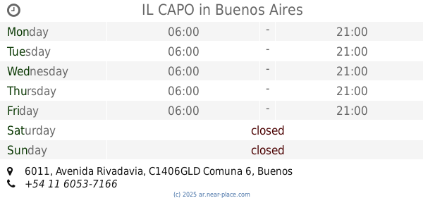
IL CAPO
Avenida Rivadavia 6011
Convenience store
read more
851 m
Marcelo
Avenida Avellaneda 476
Convenience store
read more
873 m
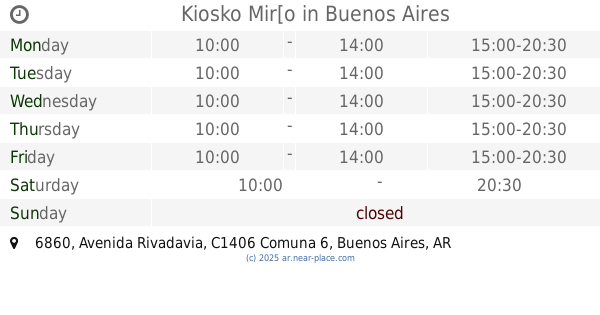
Kiosko Mir[o
Avenida Rivadavia 6860
Convenience store
read more
878 m
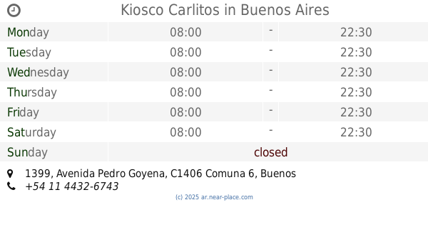
Kiosco Carlitos
Avenida Pedro Goyena 1399
Convenience store
read more
889 m
Maxikiosco Nueva Vida
Avenida Acoyte 468
Convenience store
read more
937 m
Kiosco Díaz Sandra
Avenida Juan Bautista Alberdi 209
Convenience store
read more
1.096 km
Aloise Vanesa Alejandra
Campichuelo 408
Convenience store
read more
1.146 km
Kiosko Kika
Malvinas Argentinas 281
Convenience store
read more
1.172 km
El Dorado
Avenida Avellaneda 253
Convenience store
read more
1.252 km
Sergio
Río de Janeiro 82
Convenience store
read more
📑
all categories
Accounting
Administrative area level 1
Administrative area level 2
Airport
Amusement park
Aquarium
Art gallery
Atm
Bakery
Bank
Bar
Beauty salon
Bicycle store
Book store
Bowling alley
Bus station
Cafe
Campground
Car dealer
Car rental
Car repair
Car wash
Casino
Cemetery
Church
City hall
Clothing store
Colloquial area
Convenience store
Country
Courthouse
Dentist
Department store
Doctor
Electrician
Electronics store
Embassy
Establishment
Finance
Fire station
Florist
Food
Funeral home
Furniture store
Gas station
General contractor
Grocery or supermarket
Gym
Hair care
Hardware store
Health
Hindu Temple
Home goods store
Hospital
Insurance agency
Intersection
Jewelry store
Laundry
Lawyer
Library
Light rail station
Liquor store
Local government office
Locality
Locksmith
Lodging
Meal delivery
Meal takeaway
Mosque
Movie rental
Movie theater
Moving company
Museum
Natural feature
Neighborhood
Night club
Painter
Park
Parking
Pet store
Pharmacy
Physiotherapist
Place of worship
Plumber
Point of interest
Police
Political
Post office
Premise
Real estate agency
Restaurant
Roofing contractor
Route
Rv park, camping
School
Shoe store
Shopping mall
Spa
Stadium
Storage
Store
Subpremise
Subway station
Supermarket
Synagogue
Taxi stand
Train station
Transit station
Travel agency
University
Veterinary care
Zoo
sublocality level 1
sublocality level 3
↑