Convenience store nearby MAXIKIOSCO PAVON
Argentina
Convenience store nearby MAXIKIOSCO PAVON
MAXIKIOSCO PAVON
4100, Pavón, C1253, Comuna 5, Buenos Aires, AR Argentina
contacts phone
:
+54
Latitude:
-34.631057
, Longitude:
-58.421666
larger map & directions
read more
nearest Convenience store
356 m
Casa Zhangcito
Castro 1751
Convenience store
read more
592 m
Kiosco Imperio
Avenida Boedo 1695
Convenience store
read more
664 m
ABRA K-DABRA
Avenida Directorio 14
Convenience store
read more
805 m
De Todo Un Poco
Avenida La Plata 1997
Convenience store
read more
857 m
MY Buenos Aires Querido
Avenida La Plata 2029
Convenience store
read more
941 m
Maxikiosco Avenida
Avenida Caseros 3801
Convenience store
read more
974 m
Romy Maxikiosco payment faciol
Avenida Caseros 3808
Convenience store
read more
979 m
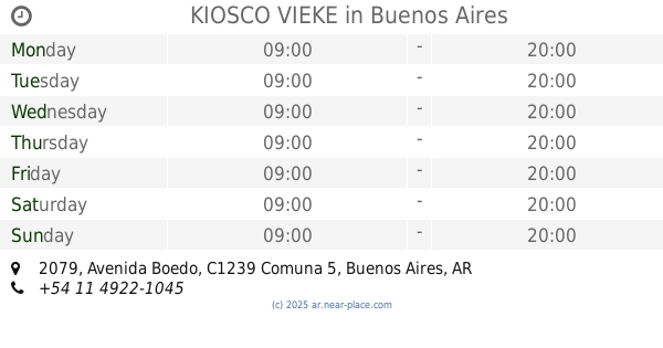
KIOSCO VIEKE
Avenida Boedo 2079
Convenience store
read more
979 m
Pago Facil Maxikiosco Romy
Avenida Caseros 3808
Convenience store
read more
1.035 km
Mary & Bel
Avenida Caseros 3547
Convenience store
read more
1.041 km
Dreams store
Maza 1002
Convenience store
read more
1.203 km
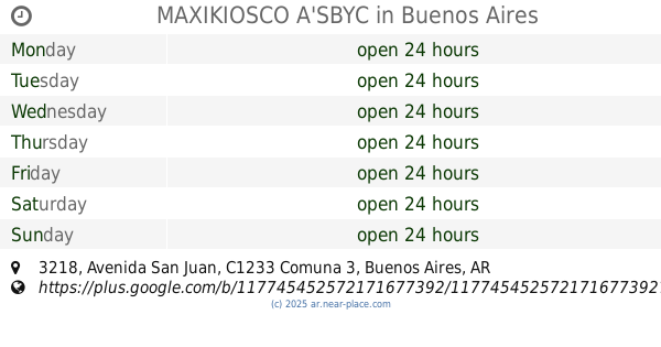
MAXIKIOSCO A'SBYC
Avenida San Juan 3218
Convenience store
read more
1.265 km
Locutorio Internet Maxikiosco Chloe
Avenida Cobo 872
Convenience store
read more
1.286 km
Kiosco Díaz Sandra
Avenida Juan Bautista Alberdi 209
Convenience store
read more
1.676 km
Kiosco Urquiza
General Urquiza 781
Convenience store
read more
1.695 km
MAXIKIOSCO DANICO
Deán Funes 1110
Convenience store
read more
1.775 km
El Lagarto
Avenida La Plata 105
Convenience store
read more
1.866 km
Kiosco La Esquina
Avenida Caseros 2801
Convenience store
read more
1.93 km
OPEN 25 HS!
Avenida Rivadavia 4585
Convenience store
read more
2.006 km
OPEN 25 HS!
Rosario 756
Convenience store
read more
2.022 km
LA ESQUINA
Avenida Independencia 2800
Convenience store
read more
2.155 km
Supermercado Esrey
Colpayo 49
Convenience store
read more
2.179 km
Todo Por 2 $
Avenida Rivadavia 5470
Convenience store
read more
2.399 km
El Emperador
Avenida Belgrano 2792
Convenience store
read more
2.654 km
Huilfredo Vera
Moreno 2531
Convenience store
read more
📑
all categories
Accounting
Administrative area level 1
Administrative area level 2
Airport
Amusement park
Aquarium
Art gallery
Atm
Bakery
Bank
Bar
Beauty salon
Bicycle store
Book store
Bowling alley
Bus station
Cafe
Campground
Car dealer
Car rental
Car repair
Car wash
Casino
Cemetery
Church
City hall
Clothing store
Colloquial area
Convenience store
Country
Courthouse
Dentist
Department store
Doctor
Electrician
Electronics store
Embassy
Establishment
Finance
Fire station
Florist
Food
Funeral home
Furniture store
Gas station
General contractor
Grocery or supermarket
Gym
Hair care
Hardware store
Health
Hindu Temple
Home goods store
Hospital
Insurance agency
Intersection
Jewelry store
Laundry
Lawyer
Library
Light rail station
Liquor store
Local government office
Locality
Locksmith
Lodging
Meal delivery
Meal takeaway
Mosque
Movie rental
Movie theater
Moving company
Museum
Natural feature
Neighborhood
Night club
Painter
Park
Parking
Pet store
Pharmacy
Physiotherapist
Place of worship
Plumber
Point of interest
Police
Political
Post office
Premise
Real estate agency
Restaurant
Roofing contractor
Route
Rv park, camping
School
Shoe store
Shopping mall
Spa
Stadium
Storage
Store
Subpremise
Subway station
Supermarket
Synagogue
Taxi stand
Train station
Transit station
Travel agency
University
Veterinary care
Zoo
sublocality level 1
sublocality level 3
↑