Convenience store nearby ROTISERÍA MARIANITA
Argentina
Convenience store nearby ROTISERÍA MARIANITA
ROTISERÍA MARIANITA
247, La Rioja, C1214, Comuna 3, Buenos Aires, AR Argentina
contacts phone
:
+54 11 4932-8997
Latitude:
-34.613372
, Longitude:
-58.408778
larger map & directions
read more
nearest Convenience store
180 m
Newsstand
La Rioja 397
Convenience store
read more
192 m
Locutorio La Rioja
La Rioja 113
Convenience store
read more
204 m
OSCAR
Avenida Belgrano 2994
Convenience store
read more
391 m
Mery
Avenida Belgrano 3281
Convenience store
read more
399 m
El Emperador
Avenida Belgrano 2792
Convenience store
read more
497 m
Juan Carlos Romero
Venezuela 2678
Convenience store
read more
576 m
Mega Kiosco
Estación Once, Avenida Pueyrredón 110
Convenience store
read more
579 m
TODOMODA
Estación Once, Avenida Pueyrredón 110
Convenience store
read more
589 m
Huilfredo Vera
Moreno 2531
Convenience store
read more
721 m
Kiosco Urquiza
General Urquiza 781
Convenience store
read more
722 m
LA ACADE
Castelli 198
Convenience store
read more
738 m
Celina
Calle Paso 134
Convenience store
read more
744 m
LA ESQUINA
Avenida Independencia 2800
Convenience store
read more
774 m
Teresa Kiosco
Matheu 313
Convenience store
read more
783 m
Juan C Carrasco
Avenida Hipólito Yrigoyen 2426
Convenience store
read more
869 m
A Y A
Azcuénaga 76
Convenience store
read more
950 m
Biuteri
Valentín Gómez 2715
Convenience store
read more
957 m
Mayorista Importador Directo
Larrea 290
Convenience store
read more
988 m
KIOSCO LA RIOJA
La Rioja 1004
Convenience store
read more
991 m
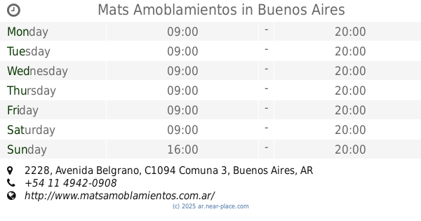
Mats Amoblamientos
Avenida Belgrano 2228
Convenience store
read more
1.005 km
El Tricolor
Presidente Teniente General Juan Domingo Perón 3501
Convenience store
read more
1.105 km
Sun Light
Sarmiento 2384
Convenience store
read more
1.159 km
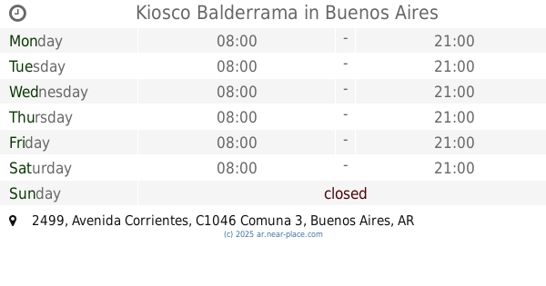
Kiosco Balderrama
Avenida Corrientes 2499
Convenience store
read more
1.171 km
Jose Luis Converti
Azcuénaga 376
Convenience store
read more
1.379 km
El Rubi
Avenida Corrientes 2209
Convenience store
read more
📑
all categories
Accounting
Administrative area level 1
Administrative area level 2
Airport
Amusement park
Aquarium
Art gallery
Atm
Bakery
Bank
Bar
Beauty salon
Bicycle store
Book store
Bowling alley
Bus station
Cafe
Campground
Car dealer
Car rental
Car repair
Car wash
Casino
Cemetery
Church
City hall
Clothing store
Colloquial area
Convenience store
Country
Courthouse
Dentist
Department store
Doctor
Electrician
Electronics store
Embassy
Establishment
Finance
Fire station
Florist
Food
Funeral home
Furniture store
Gas station
General contractor
Grocery or supermarket
Gym
Hair care
Hardware store
Health
Hindu Temple
Home goods store
Hospital
Insurance agency
Intersection
Jewelry store
Laundry
Lawyer
Library
Light rail station
Liquor store
Local government office
Locality
Locksmith
Lodging
Meal delivery
Meal takeaway
Mosque
Movie rental
Movie theater
Moving company
Museum
Natural feature
Neighborhood
Night club
Painter
Park
Parking
Pet store
Pharmacy
Physiotherapist
Place of worship
Plumber
Point of interest
Police
Political
Post office
Premise
Real estate agency
Restaurant
Roofing contractor
Route
Rv park, camping
School
Shoe store
Shopping mall
Spa
Stadium
Storage
Store
Subpremise
Subway station
Supermarket
Synagogue
Taxi stand
Train station
Transit station
Travel agency
University
Veterinary care
Zoo
sublocality level 1
sublocality level 3
↑