Convenience store nearby Simones
Argentina
Convenience store nearby Simones
Simones
3253, Avenida Santa Fe, C1425BGH, Comuna 14, Buenos Aires, AR Argentina
contacts phone
:
+54 11 5777-8128
website:
www.simones.com.ar
Latitude:
-34.587568
, Longitude:
-58.409581
larger map & directions
read more
nearest Convenience store
65 m
OPEN 25 HS!
Avenida Coronel Díaz 2037
Convenience store
read more
376 m
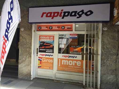
Rapipago
Peña 3176
Convenience store
read more
393 m
Maxikiosco Molinari
Juncal 3406
Convenience store
read more
423 m
Despensa
French 2920
Convenience store
read more
604 m
Autoservicio Pampero 2
Peña 2800
Convenience store
read more
653 m
Cristina Monica Luna Yoret
Ortiz de Ocampo 2552
Convenience store
read more
692 m
Mono Loco
Charcas 3698
Convenience store
read more
694 m
Martin G Jimenez
Paraguay 3419
Convenience store
read more
741 m
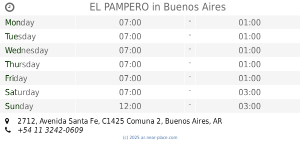
EL PAMPERO
Avenida Santa Fe 2712
Convenience store
read more
775 m
Isadora
Cabello 3621
Convenience store
read more
791 m
Kiosco Garrido
Laprida 1222
Convenience store
read more
791 m
Quiosco Gallo
Gallo 1319
Convenience store
read more
829 m
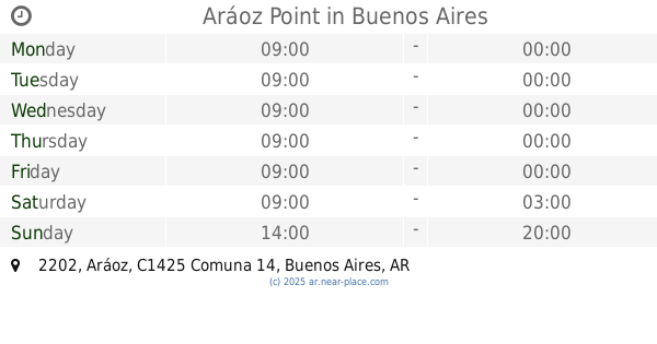
Aráoz Point
Aráoz 2202
Convenience store
read more
877 m
Quiosco Paraguay
Paraguay 3009
Convenience store
read more
880 m
QUIOSCO ANCHORENA
Doctor Tomás Manuel de Anchorena 1208
Convenience store
read more
928 m
Maxiquiosco Ecuador
Ecuador 1374
Convenience store
read more
956 m
JMG
Juan María Gutiérrez 2613
Convenience store
read more
985 m
BUIKA CARTERAS
Avenida Pueyrredón 1972, Buenos Aires
Convenience store
read more
991 m
365 Kioscos Argentinos
Juncal 2302
Convenience store
read more
996 m
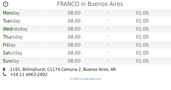
FRANCO
Billinghurst 1191
Convenience store
read more
1.001 km
Laura Ortiz
Soler 3300
Convenience store
read more
1.201 km
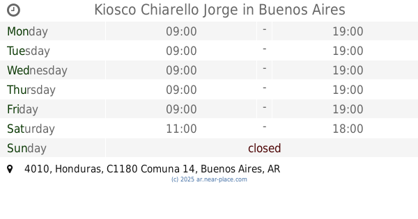
Kiosco Chiarello Jorge
Honduras 4010
Convenience store
read more
1.273 km
Consultorio Dr Curuchet
Avenida Santa Fe 2245
Convenience store
read more
1.275 km
DRUGSTORE
Marcelo Torcuato de Alvear 2335
Convenience store
read more
1.348 km
El kiosquito
Presidente José Evaristo Uriburu 1086
Convenience store
read more
📑
all categories
Accounting
Administrative area level 1
Administrative area level 2
Airport
Amusement park
Aquarium
Art gallery
Atm
Bakery
Bank
Bar
Beauty salon
Bicycle store
Book store
Bowling alley
Bus station
Cafe
Campground
Car dealer
Car rental
Car repair
Car wash
Casino
Cemetery
Church
City hall
Clothing store
Colloquial area
Convenience store
Country
Courthouse
Dentist
Department store
Doctor
Electrician
Electronics store
Embassy
Establishment
Finance
Fire station
Florist
Food
Funeral home
Furniture store
Gas station
General contractor
Grocery or supermarket
Gym
Hair care
Hardware store
Health
Hindu Temple
Home goods store
Hospital
Insurance agency
Intersection
Jewelry store
Laundry
Lawyer
Library
Light rail station
Liquor store
Local government office
Locality
Locksmith
Lodging
Meal delivery
Meal takeaway
Mosque
Movie rental
Movie theater
Moving company
Museum
Natural feature
Neighborhood
Night club
Painter
Park
Parking
Pet store
Pharmacy
Physiotherapist
Place of worship
Plumber
Point of interest
Police
Political
Post office
Premise
Real estate agency
Restaurant
Roofing contractor
Route
Rv park, camping
School
Shoe store
Shopping mall
Spa
Stadium
Storage
Store
Subpremise
Subway station
Supermarket
Synagogue
Taxi stand
Train station
Transit station
Travel agency
University
Veterinary care
Zoo
sublocality level 1
sublocality level 3
↑