Dentist nearby Circulo Odontologico Zarate
Argentina
Dentist nearby Circulo Odontologico Zarate
Circulo Odontologico Zarate
Independencia 625, Z�rate, Buenos Aires, C1069 CABA, Argentinien
contacts phone
:
+54 3487 42-3565
Latitude:
-34.6172687
, Longitude:
-58.3748073
larger map & directions
read more
nearest Dentist
129 m
Dr Algel Gabriel Palau
Avenida Independencia 531
Dentist
read more
181 m
Huberman Sergio G
Perú 666
Dentist
read more
235 m
Programa Dental
Piedras 813
Dentist
read more
243 m
Cerra Miguel Odontologo
Bolívar 660
Dentist
read more
326 m
CERIK
C1069AAK, Chacabuco 567
Dentist
read more
337 m
Cerik3d
C1069AAK, Chacabuco 567
Dentist
read more
349 m
Dental San Telmo
Avenida Independencia 886
Dentist
read more
469 m
Lemos Marta A
Bolívar 1139
Dentist
read more
474 m
Guimil Beatriz S M
Bolívar 1143
Dentist
read more
481 m
Asociacion Implantodontologica Argentina
Avenida Paseo Colón 797
Dentist
read more
546 m
Sella Edmundo
Avenida San Juan 532
Dentist
read more
576 m
Odontología San Telmo
Perú 1237
Dentist
read more
583 m
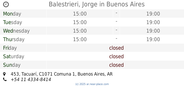
Balestrieri, Jorge
Tacuarí 453
Dentist
read more
696 m
Bense Jorge A
Moreno 428
Dentist
read more
795 m
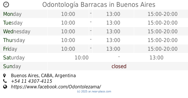
Odontología Barracas
Dentist
read more
811 m
Odontologia San Telmo
Piedras 1351
Dentist
read more
883 m
Consultorio San Nicolas
664, Santiago del Estero
Dentist
read more
962 m
Jensen Robert
Avenida de Mayo 786
Dentist
read more
1.022 km
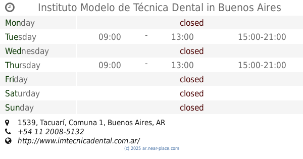
Instituto Modelo de Técnica Dental
Tacuarí 1539
Dentist
read more
1.022 km
MAYCENTER 5to Oiso
Avenida de Mayo 950
Dentist
read more
1.022 km
Laboratorio Modelo de Técnica Dental
Tacuarí 1541
Dentist
read more
1.028 km
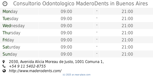
Consultorio Odontologico MaderoDents
2050, Avenida Alicia Moreau de Justo 2030
Dentist
read more
1.028 km
Mancini Eduardo L
Avenida San Juan 1299
Dentist
read more
1.076 km
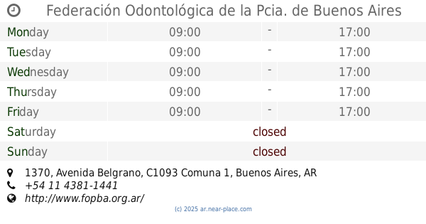
Federación Odontológica de la Pcia. de Buenos Aires
Avenida Belgrano 1370
Dentist
read more
1.347 km
Kilden Centro Odontologico Integral
Talcahuano 33
Dentist
read more
📑
all categories
Accounting
Administrative area level 1
Administrative area level 2
Airport
Amusement park
Aquarium
Art gallery
Atm
Bakery
Bank
Bar
Beauty salon
Bicycle store
Book store
Bowling alley
Bus station
Cafe
Campground
Car dealer
Car rental
Car repair
Car wash
Casino
Cemetery
Church
City hall
Clothing store
Colloquial area
Convenience store
Country
Courthouse
Dentist
Department store
Doctor
Electrician
Electronics store
Embassy
Establishment
Finance
Fire station
Florist
Food
Funeral home
Furniture store
Gas station
General contractor
Grocery or supermarket
Gym
Hair care
Hardware store
Health
Hindu Temple
Home goods store
Hospital
Insurance agency
Intersection
Jewelry store
Laundry
Lawyer
Library
Light rail station
Liquor store
Local government office
Locality
Locksmith
Lodging
Meal delivery
Meal takeaway
Mosque
Movie rental
Movie theater
Moving company
Museum
Natural feature
Neighborhood
Night club
Painter
Park
Parking
Pet store
Pharmacy
Physiotherapist
Place of worship
Plumber
Point of interest
Police
Political
Post office
Premise
Real estate agency
Restaurant
Roofing contractor
Route
Rv park, camping
School
Shoe store
Shopping mall
Spa
Stadium
Storage
Store
Subpremise
Subway station
Supermarket
Synagogue
Taxi stand
Train station
Transit station
Travel agency
University
Veterinary care
Zoo
sublocality level 1
sublocality level 3
↑