Gas station nearby GAS ING SA
Argentina
Gas station nearby GAS ING SA
GAS ING SA
3412, Sarmiento, C1196, Comuna 5, Buenos Aires, AR Argentina
contacts phone
:
+54 11 4861-5525
Latitude:
-34.6061962
, Longitude:
-58.4140254
larger map & directions
read more
nearest Gas station
383 m
Love Street
Presidente Teniente General Juan Domingo Perón 3679, C1198AAQ
Gas station
read more
459 m
Petrugas S.a.
Bartolomé Mitre 3595
Gas station
read more
479 m
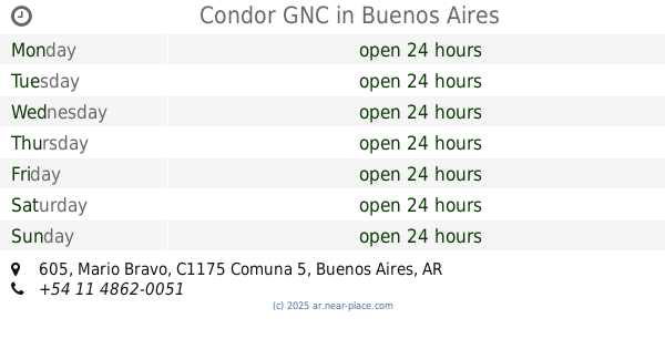
Condor GNC
Mario Bravo 605
Gas station
read more
480 m
YPF
Cdad.
Gas station
read more
482 m
Automóvil Club Argentino
Avenida Rivadavia 3341
Gas station
read more
484 m
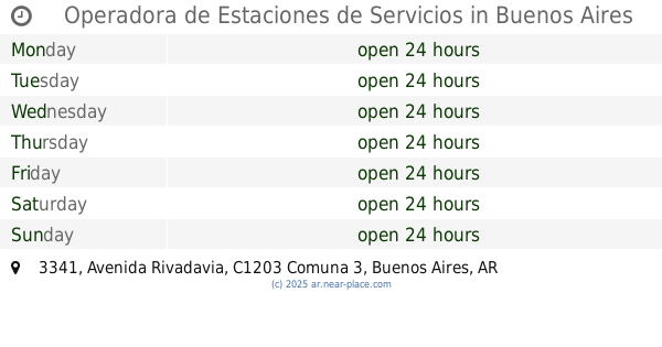
Operadora de Estaciones de Servicios
Avenida Rivadavia 3341
Gas station
read more
484 m
YPF
Avenida Rivadavia 3341, Buenos Aires
Gas station
read more
518 m
Cors Anchorena
Avenida Rivadavia 3197
Gas station
read more
520 m
Shell
C1193AAD, Avenida Corrientes 3101
Gas station
read more
521 m
Axon
Avenida Rivadavia 3197
Gas station
read more
524 m
AXION energy
Avenida Rivadavia 3199
Gas station
read more
600 m
Petrobras Service Station (Dual)
Avenida Rivadavia, Buenos Aires
Gas station
read more
844 m
G.N.C.
C1171ABP, Agüero 930
Gas station
read more
853 m
Estación De Servicio Oil
C1186ACI, San Luis 3187
Gas station
read more
853 m
Oil Service Station
C1186ACI, San Luis 3187
Gas station
read more
865 m
Gnc Gazzola
Mario Bravo 960
Gas station
read more
869 m
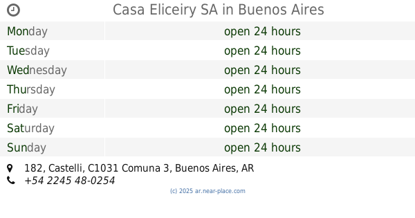
Casa Eliceiry SA
Castelli 182
Gas station
read more
1.001 km
Diagas
Argentina
Gas station
read more
1.034 km
AXION energy
AvenidaJUJUY Y ALSINA
Gas station
read more
1.034 km
Estación de servicio Axion
AvenidaJUJUY Y ALSINA
Gas station
read more
1.034 km
Shell
3700, Avenida Córdoba
Gas station
read more
1.042 km
Axion Energy Gnc
C1090AAS, Adolfo Alsina 2747-2799
Gas station
read more
1.171 km
Gomeria
C1181ACR, Gascón 992
Gas station
read more
1.198 km
Petrobras GNC
C1187AAB, Avenida Córdoba 2745
Gas station
read more
1.345 km
GNC
Avenida Estado de Israel 4177
Gas station
read more
📑
all categories
Accounting
Administrative area level 1
Administrative area level 2
Airport
Amusement park
Aquarium
Art gallery
Atm
Bakery
Bank
Bar
Beauty salon
Bicycle store
Book store
Bowling alley
Bus station
Cafe
Campground
Car dealer
Car rental
Car repair
Car wash
Casino
Cemetery
Church
City hall
Clothing store
Colloquial area
Convenience store
Country
Courthouse
Dentist
Department store
Doctor
Electrician
Electronics store
Embassy
Establishment
Finance
Fire station
Florist
Food
Funeral home
Furniture store
Gas station
General contractor
Grocery or supermarket
Gym
Hair care
Hardware store
Health
Hindu Temple
Home goods store
Hospital
Insurance agency
Intersection
Jewelry store
Laundry
Lawyer
Library
Light rail station
Liquor store
Local government office
Locality
Locksmith
Lodging
Meal delivery
Meal takeaway
Mosque
Movie rental
Movie theater
Moving company
Museum
Natural feature
Neighborhood
Night club
Painter
Park
Parking
Pet store
Pharmacy
Physiotherapist
Place of worship
Plumber
Point of interest
Police
Political
Post office
Premise
Real estate agency
Restaurant
Roofing contractor
Route
Rv park, camping
School
Shoe store
Shopping mall
Spa
Stadium
Storage
Store
Subpremise
Subway station
Supermarket
Synagogue
Taxi stand
Train station
Transit station
Travel agency
University
Veterinary care
Zoo
sublocality level 1
sublocality level 3
↑