Gas station nearby Talle Mecánico ItalCar
Argentina
Gas station nearby Talle Mecánico ItalCar
Talle Mecánico ItalCar
176, Hernandarias, C1165, Comuna 4, Buenos Aires, AR Argentina
contacts phone
:
+54
Latitude:
-34.6304732
, Longitude:
-58.3695178
larger map & directions
read more
nearest Gas station
284 m
Le Service Guini
Bolívar 1770, Buenos Aires
Gas station
read more
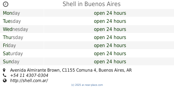
559 m
Shell
600, Avenida Almirante Brown
Gas station
read more
564 m
Shell
Avenida Almirante Brown 600
Gas station
read more
636 m
Darina Sa
J M Paz 2, Ituzaingo
Gas station
read more
642 m
YPF
Avenida Montes de Oca 492, Buenos Aires
Gas station
read more
645 m
Naftas y Gnc Lubricentro Boca - Distribuidor
Avenida Almirante Brown 678
Gas station
read more
660 m
Automóvil Club Argentino
Avenida Montes de Oca
Gas station
read more
674 m
YPF
Avenida Martín García 898-900
Gas station
read more
797 m
Alvares Tomas Y Juramento
General Hornos 501-599, C1272ACI
Gas station
read more
852 m
Lavadero
C1155AGH, Benito Pérez Galdos 350
Gas station
read more
911 m
Terminal 130
Necochea 842-808
Gas station
read more
939 m
Service Station Gnc COTAX
Gas station
read more
939 m
Estación de Servicios Gnc COTAX
Gas station
read more
939 m
Naftas y GNC YPF
Gas station
read more
1.061 km
Blanca (Gnc)
Aristóbulo del Valle 1907
Gas station
read more
1.062 km
Gnv
Gas station
read more
1.286 km
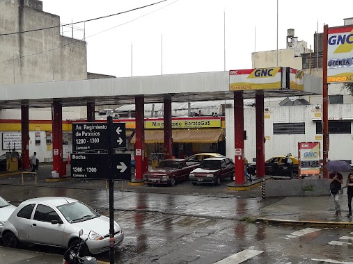
Barato Gas
Rocha 1200
Gas station
read more
1.751 km
Gomeria Pipo
Estados Unidos 1200-1100, C1101AAX
Gas station
read more
1.763 km
Chochi Lavadero
1600 C1269AAH, Azara 1502
Gas station
read more
1.776 km
Shell Osde
Los Patos 1740
Gas station
read more
1.786 km
YPF
Avenida Regimiento de Patricios, Tristan Suárez
Gas station
read more
1.962 km
Mexi Gas (Solo GNC)
Bernardo de Irigoyen 592
Gas station
read more
2.06 km
G.N.C.
Gas station
read more
2.405 km
YPF
Avenida dr velez sarsfield 850
Gas station
read more
2.462 km
YPF Velez Sarsfield
Avenida Vélez Sarsfield 901
Gas station
read more
📑
all categories
Accounting
Administrative area level 1
Administrative area level 2
Airport
Amusement park
Aquarium
Art gallery
Atm
Bakery
Bank
Bar
Beauty salon
Bicycle store
Book store
Bowling alley
Bus station
Cafe
Campground
Car dealer
Car rental
Car repair
Car wash
Casino
Cemetery
Church
City hall
Clothing store
Colloquial area
Convenience store
Country
Courthouse
Dentist
Department store
Doctor
Electrician
Electronics store
Embassy
Establishment
Finance
Fire station
Florist
Food
Funeral home
Furniture store
Gas station
General contractor
Grocery or supermarket
Gym
Hair care
Hardware store
Health
Hindu Temple
Home goods store
Hospital
Insurance agency
Intersection
Jewelry store
Laundry
Lawyer
Library
Light rail station
Liquor store
Local government office
Locality
Locksmith
Lodging
Meal delivery
Meal takeaway
Mosque
Movie rental
Movie theater
Moving company
Museum
Natural feature
Neighborhood
Night club
Painter
Park
Parking
Pet store
Pharmacy
Physiotherapist
Place of worship
Plumber
Point of interest
Police
Political
Post office
Premise
Real estate agency
Restaurant
Roofing contractor
Route
Rv park, camping
School
Shoe store
Shopping mall
Spa
Stadium
Storage
Store
Subpremise
Subway station
Supermarket
Synagogue
Taxi stand
Train station
Transit station
Travel agency
University
Veterinary care
Zoo
sublocality level 1
sublocality level 3
↑