Health nearby CLINIKER
Argentina
Health nearby CLINIKER
CLINIKER
1570, Gallo, C1425, Comuna 2, Buenos Aires, AR Argentina
contacts phone
:
+54 11 4826-0394
Latitude:
-34.5919514
, Longitude:
-58.4094129
larger map & directions
read more
nearest Health
227 m
Embarazo Activo
Charcas
Health
read more
381 m
Dr. Néstor Vincent
Sánchez de Bustamante 1986 Piso 2 C
Health
read more
396 m
AllerNutrition
Charcas 3377
Health
read more
434 m
R.ED.ES Autismo Integración
Charcas 3397
Health
read more
482 m
Diagnostics Laboratory Imaging Fundus
Antonio Beruti 3267
Health
read more
482 m
Diagnostics Laboratory Imaging Fundus
Beruti 3267
Health
read more
539 m
Mf Nutrition
Laprida 1011
Health
read more
644 m
Dental Assistance
Arenales 2547
Dentist
Health
Point of interest
Establishment
read more
657 m
Insti Geriatrico de Rehab Integral
Billinghurst 2180
Health
read more
658 m
Jardín Diurni
Billinghurst 2180
Health
read more
699 m
Ch servis maletas
French 3162
Health
read more
742 m
Smartservices Argentina
Agüero 955 Piso 7
Health
read more
762 m
Delgado Osvaldo
General Lucio Norberto Mansilla 3817
Health
read more
791 m
PROTOCOL.AR Protocolo-Ceremonial-Eventos
Peña 2871
Health
read more
864 m
Halitus Instituto Médico Sede Larrea
Larrea 1007
Health
read more
866 m
Centro Larrea
Larrea 958
Health
read more
959 m
Clínica del Pilar Sa
Marcelo Torcuato de Alvear 2323
Health
read more
959 m
Cirujano Plástico
Charcas, Buenos Aires2777
Health
read more
986 m
Dr. Allevato Miguel A. Y Equipo Enfermedades De La Piel
Paraguay 2345
Health
read more
1.044 km
Manlab
C1122AAI, Marcelo Torcuato de Alvear 2263
Health
read more
1.06 km
Dr. Dalton Ricardo Alfredo
Güemes 4058
Health
read more
1.087 km
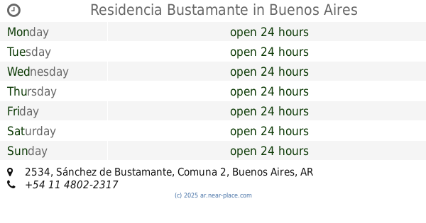
Residencia Bustamante
Sánchez de Bustamante 2534
Health
read more
1.122 km
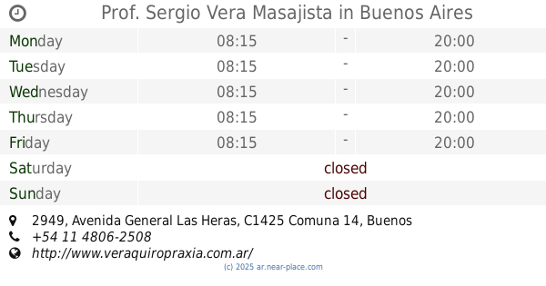
Prof. Sergio Vera Masajista
Avenida General Las Heras 2949
Health
read more
1.209 km
Federacion de Piscologos de L
Azcuénaga 767
Health
read more
1.321 km
Koinonia Centro de Investigación, Capacitación y Consultoría
Avenida Santa Fe 3942 8 B
Health
read more
📑
all categories
Accounting
Administrative area level 1
Administrative area level 2
Airport
Amusement park
Aquarium
Art gallery
Atm
Bakery
Bank
Bar
Beauty salon
Bicycle store
Book store
Bowling alley
Bus station
Cafe
Campground
Car dealer
Car rental
Car repair
Car wash
Casino
Cemetery
Church
City hall
Clothing store
Colloquial area
Convenience store
Country
Courthouse
Dentist
Department store
Doctor
Electrician
Electronics store
Embassy
Establishment
Finance
Fire station
Florist
Food
Funeral home
Furniture store
Gas station
General contractor
Grocery or supermarket
Gym
Hair care
Hardware store
Health
Hindu Temple
Home goods store
Hospital
Insurance agency
Intersection
Jewelry store
Laundry
Lawyer
Library
Light rail station
Liquor store
Local government office
Locality
Locksmith
Lodging
Meal delivery
Meal takeaway
Mosque
Movie rental
Movie theater
Moving company
Museum
Natural feature
Neighborhood
Night club
Painter
Park
Parking
Pet store
Pharmacy
Physiotherapist
Place of worship
Plumber
Point of interest
Police
Political
Post office
Premise
Real estate agency
Restaurant
Roofing contractor
Route
Rv park, camping
School
Shoe store
Shopping mall
Spa
Stadium
Storage
Store
Subpremise
Subway station
Supermarket
Synagogue
Taxi stand
Train station
Transit station
Travel agency
University
Veterinary care
Zoo
sublocality level 1
sublocality level 3
↑