Health nearby RAYMOS
Argentina
Health nearby RAYMOS
RAYMOS
2775, Vuelta de Obligado, C1428, Comuna 13, Buenos Aires, AR Argentina
contacts phone
:
+54
Latitude:
-34.555426
, Longitude:
-58.460708
larger map & directions
read more
nearest Health
171 m
Argentina alliance of Reiki Masters
Franklin D. Roosevelt 2315
Health
read more
308 m
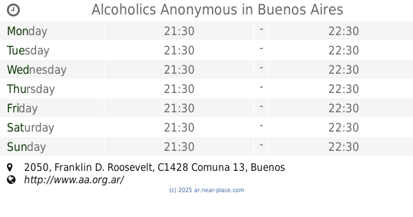
Alcoholics Anonymous
Franklin D. Roosevelt 2050
Health
read more
388 m
Lab. Bioquímico Belgrano S.R.L.
Arcos 2460
Health
read more
439 m
dra Satto Eugenia 4703 1554
Arcos 3053, C1429AZE
Health
read more
448 m
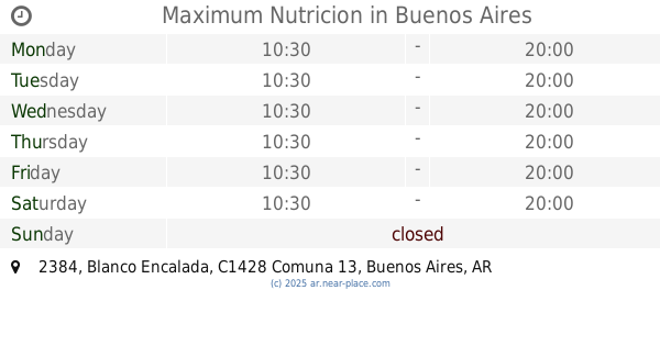
Maximum Nutricion
Blanco Encalada 2384
Health
read more
449 m
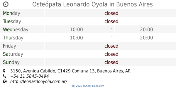
Osteópata Leonardo Oyola
C1429AAP, Avenida Cabildo 3150
Health
read more
554 m
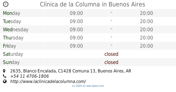
Clínica de la Columna
Blanco Encalada 2635
Health
read more
556 m
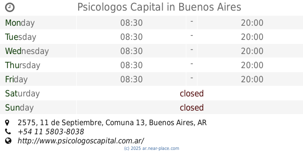
Psicologos Capital
11 de Septiembre 2575
Health
read more
572 m
Consultorio Dr. Mangiafico
DHS, Avenida Olazábal 2390
Health
read more
644 m
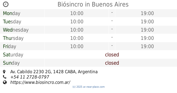
Biósincro
Av. Cabildo 2230 2G
Health
read more
784 m
Shiatsu Buenos Aires
Montañeses 2937
Health
read more
830 m
ALCOHÓLICOS ANONIMOS GRUPO OLAZABAL
Avenida Olazábal 2842
Health
read more
860 m
Dra. Elba Garber Psicoanalista - Psiquiatra
Mendoza 1788
Health
read more
868 m
Vision Clara
Mendoza 2800
Health
read more
870 m
Elegí Vivir Sano
Amenábar 3446
Health
read more
889 m
EL REPARO COMUNIDAD TERAPÉUTICA
Mendoza 2812
Health
read more
893 m
Edificio Manantial
Núñez 2578
Health
read more
927 m
Dra. Scattini Claudina
Nuñez 2638
Dentist
Point of interest
Health
Establishment
read more
963 m
Fleni, entrada proveedores
Olazábal 1561
Health
read more
970 m
Mindfulnes Ahora
Echeverría 2063
Health
read more
1.004 km
NARCÓTICOS ANÓNIMOS Grupo Conesa Fé
Conesa 2224
Health
read more
1.105 km
EL LAR DE LOS MAYORES
C1428CZH, Capitán General Ramón Freire 2362
Health
read more
1.2 km
Consultorios Garcia del Rio
Avenida García del Río 2646
Health
read more
1.279 km
Menken Pharma & Medical
Paroissien 2440
Health
read more
1.297 km
Grupo Aukera Consultores
Amenábar 3843
Health
read more
📑
all categories
Accounting
Administrative area level 1
Administrative area level 2
Airport
Amusement park
Aquarium
Art gallery
Atm
Bakery
Bank
Bar
Beauty salon
Bicycle store
Book store
Bowling alley
Bus station
Cafe
Campground
Car dealer
Car rental
Car repair
Car wash
Casino
Cemetery
Church
City hall
Clothing store
Colloquial area
Convenience store
Country
Courthouse
Dentist
Department store
Doctor
Electrician
Electronics store
Embassy
Establishment
Finance
Fire station
Florist
Food
Funeral home
Furniture store
Gas station
General contractor
Grocery or supermarket
Gym
Hair care
Hardware store
Health
Hindu Temple
Home goods store
Hospital
Insurance agency
Intersection
Jewelry store
Laundry
Lawyer
Library
Light rail station
Liquor store
Local government office
Locality
Locksmith
Lodging
Meal delivery
Meal takeaway
Mosque
Movie rental
Movie theater
Moving company
Museum
Natural feature
Neighborhood
Night club
Painter
Park
Parking
Pet store
Pharmacy
Physiotherapist
Place of worship
Plumber
Point of interest
Police
Political
Post office
Premise
Real estate agency
Restaurant
Roofing contractor
Route
Rv park, camping
School
Shoe store
Shopping mall
Spa
Stadium
Storage
Store
Subpremise
Subway station
Supermarket
Synagogue
Taxi stand
Train station
Transit station
Travel agency
University
Veterinary care
Zoo
sublocality level 1
sublocality level 3
↑