Hospital nearby Congreso De Heridas
Argentina
Hospital nearby Congreso De Heridas
Congreso De Heridas
Maure 3994 Argentina
contacts phone
:
+54
Latitude:
-34.586057
, Longitude:
-58.4514951
read more
nearest Hospital
126 m
Art
Avenida Forest 500-402, C1427CEO
Hospital
read more
134 m
Consultorios Médicos Forest
Forest 408, Ciudad Autónoma de Bs As
Hospital
read more
152 m
ART Centro Médico Laboral Capital Federal
Avenida Forest 408
Hospital
read more
586 m
Nuestra Señora de Las Nieves
Avenida Álvarez Thomas 268
Hospital
read more
767 m
CEMUVA
Avenida Córdoba 5869
Hospital
read more
835 m
中华医院
C1426CQS, Avenida Federico Lacroze 3272
Hospital
read more
887 m
QueNoDuelaMas
1300, C1414CML Bonpland 1232 C1414CML
Hospital
read more
936 m
veterinaria
Avenida Álvarez Thomas 1045, C1427CCK
Hospital
read more
980 m
Centro Medico Barrial 11
C1426DWF, Gregoria Pérez 3426
Hospital
read more
985 m
Magneton Sa
Conde 817
Hospital
read more
998 m
Sanatorio Colegiales
Conde 851
Hospital
read more
1.056 km
DR. JONES Beauty & Wellness
Avenida Dorrego 1835
Hospital
read more
1.289 km
Interea Salud Mental
C1414DCN, Thames 608
Hospital
read more
1.427 km
Cia Alimentaria Nacional SA
Montenegro 1365
Hospital
read more
1.513 km
Institute of High Complexity A Fleming
Crámer 930
Hospital
read more
1.535 km
Hogar Santa Ana
Zabala 2837
Hospital
read more
1.609 km
Periferico Palpa
C1426DOH, Palpa 2680
Hospital
read more
1.8 km
OSPERYH - Centro Médico
Ciudad de La Paz 1062
Hospital
read more
1.873 km
Centro Médico Deragopyan Belgrano
Amenábar 1331, Buenos Aires
Hospital
read more
1.873 km
Deragopyan Medical Center
Amenábar 1331, Ciudad Autonoma de Buenos Aires
Hospital
read more
1.93 km
Hospital General de Agudos Dr. Enrique Tornú
Combatientes de Malvinas 3002
Hospital
read more
1.951 km
Cermed
C1425FUB, Humboldt 2200
Hospital
read more
2.098 km
Odontologia Spf
Argentina
Hospital
read more
2.099 km
Obra Social Spf
C1416EXN, Avenida Álvarez Jonte 1560
Hospital
read more
2.185 km
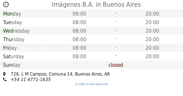
Imágenes B.A.
L M Campos 726
Hospital
read more
📑
all categories
Accounting
Administrative area level 1
Administrative area level 2
Airport
Amusement park
Aquarium
Art gallery
Atm
Bakery
Bank
Bar
Beauty salon
Bicycle store
Book store
Bowling alley
Bus station
Cafe
Campground
Car dealer
Car rental
Car repair
Car wash
Casino
Cemetery
Church
City hall
Clothing store
Colloquial area
Convenience store
Country
Courthouse
Dentist
Department store
Doctor
Electrician
Electronics store
Embassy
Establishment
Finance
Fire station
Florist
Food
Funeral home
Furniture store
Gas station
General contractor
Grocery or supermarket
Gym
Hair care
Hardware store
Health
Hindu Temple
Home goods store
Hospital
Insurance agency
Intersection
Jewelry store
Laundry
Lawyer
Library
Light rail station
Liquor store
Local government office
Locality
Locksmith
Lodging
Meal delivery
Meal takeaway
Mosque
Movie rental
Movie theater
Moving company
Museum
Natural feature
Neighborhood
Night club
Painter
Park
Parking
Pet store
Pharmacy
Physiotherapist
Place of worship
Plumber
Point of interest
Police
Political
Post office
Premise
Real estate agency
Restaurant
Roofing contractor
Route
Rv park, camping
School
Shoe store
Shopping mall
Spa
Stadium
Storage
Store
Subpremise
Subway station
Supermarket
Synagogue
Taxi stand
Train station
Transit station
Travel agency
University
Veterinary care
Zoo
sublocality level 1
sublocality level 3
↑