Hospital nearby Sanidad O.S.P.A.
Argentina
Hospital nearby Sanidad O.S.P.A.
Sanidad O.S.P.A.
148, Saavedra, C1083, Comuna 3, Buenos Aires, AR Argentina
contacts phone
:
+54
Latitude:
-34.61143
, Longitude:
-58.4031059
larger map & directions
read more
nearest Hospital
41 m
OSPSA
Saavedra 159
Hospital
read more
120 m
CMB
Saavedra 205
Hospital
read more
406 m
Hospital Franchin
Bartolomé Mitre
Hospital
read more
417 m
DMI imagenes
Alberti 447
Hospital
read more
500 m
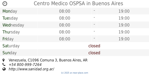
Centro Medico OSPSA
2359, ABO, Venezuela
Hospital
read more
578 m
Mevaterapia
Teniente General Juan Domingo Perón
Hospital
read more
578 m
Mevaterapia
Presidente Teniente General Juan Domingo Perón
Hospital
read more
586 m
Jonas Salk Center
Teniente General Juan Domingo Perón
Hospital
read more
586 m
Jonas Salk Center
Presidente Teniente General Juan Domingo Perón
Hospital
read more
586 m
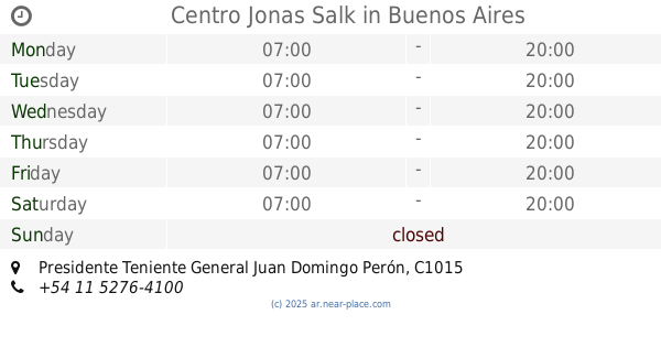
Centro Jonas Salk
Presidente Teniente General Juan Domingo Perón
Hospital
read more
620 m
Clínica Ozono Salud-Tratamiento del Dolor
Avenida Rivadavia 2134
Hospital
read more
674 m
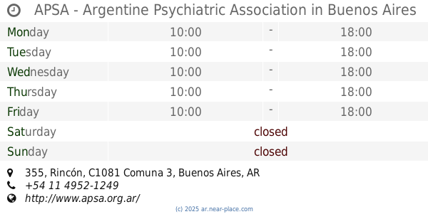
APSA - Argentine Psychiatric Association
Rincón 355
Hospital
read more
770 m
Amepba
AMEBPBA, Bartolomé Mitre 2040
Hospital
read more
803 m
Instituto Unchastegui
C1040AAF, Presidente Teniente General Juan Domingo Perón 2082
Hospital
read more
836 m
Inschausti
Presidente Teniente General Juan Domingo Perón 2047, C1040AAE
Hospital
read more
902 m
Osyc
Argentina
Hospital
read more
905 m
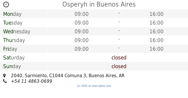
Osperyh
Sarmiento 2040
Hospital
read more
926 m
Brenda 6/7
Boulogne Sur Mer 560, Buenos Aires
Hospital
read more
989 m
Torre Hotel
Argentina SN-S ESTACIONAMIENTO ESC DE HOTEL, Monterrey
Hospital
read more
997 m
Instituto Medico Rossi
C1173ACC, Sánchez de Loria 117, Buenos Aires
Hospital
read more
1.102 km
Centro Capilar
Presidente Teniente General Juan Domingo Perón 1823
Hospital
read more
1.117 km
Nomed S.A.
Avenida Callao 194
Hospital
read more
1.162 km
OSPeDiCi
Ayacucho 514
Hospital
read more
1.173 km
OdontoTiti
Carlos Calvo 2101
Hospital
read more
1.276 km
Clinica De Rehabilitacion TÍA ANA
Gallo 499
Hospital
read more
📑
all categories
Accounting
Administrative area level 1
Administrative area level 2
Airport
Amusement park
Aquarium
Art gallery
Atm
Bakery
Bank
Bar
Beauty salon
Bicycle store
Book store
Bowling alley
Bus station
Cafe
Campground
Car dealer
Car rental
Car repair
Car wash
Casino
Cemetery
Church
City hall
Clothing store
Colloquial area
Convenience store
Country
Courthouse
Dentist
Department store
Doctor
Electrician
Electronics store
Embassy
Establishment
Finance
Fire station
Florist
Food
Funeral home
Furniture store
Gas station
General contractor
Grocery or supermarket
Gym
Hair care
Hardware store
Health
Hindu Temple
Home goods store
Hospital
Insurance agency
Intersection
Jewelry store
Laundry
Lawyer
Library
Light rail station
Liquor store
Local government office
Locality
Locksmith
Lodging
Meal delivery
Meal takeaway
Mosque
Movie rental
Movie theater
Moving company
Museum
Natural feature
Neighborhood
Night club
Painter
Park
Parking
Pet store
Pharmacy
Physiotherapist
Place of worship
Plumber
Point of interest
Police
Political
Post office
Premise
Real estate agency
Restaurant
Roofing contractor
Route
Rv park, camping
School
Shoe store
Shopping mall
Spa
Stadium
Storage
Store
Subpremise
Subway station
Supermarket
Synagogue
Taxi stand
Train station
Transit station
Travel agency
University
Veterinary care
Zoo
sublocality level 1
sublocality level 3
↑