Local government office nearby Centro De Salud Otharan
Argentina
Local government office nearby Centro De Salud Otharan
Centro De Salud Otharan
4245, Zorrilla de San Martín, B1715, Udaondo, Ituzaingó, AR Argentina
contacts phone
:
+54
Latitude:
-34.6134247
, Longitude:
-58.7011166
larger map & directions
read more
nearest Local government office
1.222 km
Sociedad De Fomento Villa Udaondo
B1713AJP, Julián Balbín 4010, Udaondo
Local government office
read more
2.204 km
Parque Leloir Asociacion Civil
De la Vidalita, Ituzaingó
Local government office
read more
3.704 km
Centro de Desarrollo Social Juana Azurduy
Haití 3400, Ituzaingó
Local government office
read more
3.814 km
Centro de Gestión y Control de Seguridad Alimentaria, Municipailidad de Merlo
B1722JMW, Avenida Hipólito Yrigoyen 2316, Merlo
Local government office
read more
3.944 km
Calico
Juana Manuela Gorriti 3950, William C. Morris
Local government office
read more
3.986 km
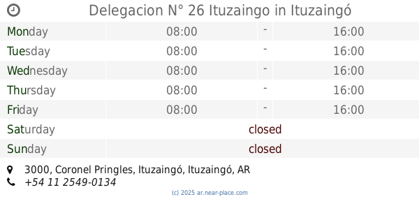
Delegacion N° 26 Ituzaingo
Coronel Pringles 3000, Ituzaingó
Local government office
read more
4.022 km
Registro Seccional. 25134 - MORON B
Ituzaingó
Local government office
read more
4.771 km
Movimientos De Suelo Y Arenados
B1742GET, Deán Funes 4156, Paso del Rey
Local government office
read more
4.78 km
Registro Nacional de la Propiedad del Automotor N° 1
Coronel Brandsen 1048, Gran Buenos Aires
Local government office
read more
4.786 km
Registro Motovehiculos Moron B
1048, Coronel Brandsen, Ituzaingó
Local government office
read more
5.461 km
CENTRO DE ATENCION TRIBUTARIA WILLIAM MORRIS
General Conrado Villegas 1471, Gran Buenos Aires
Local government office
read more
5.465 km
MINISTERIO DE GOBIERNO DE LA PCIA. DE BUENOS AIRES DELEGACIÓN DEL REGISTRO DE LAS PERSONAS DE WILLIAM C. MORRIS
General Conrado Villegas, Hurlingham
Local government office
read more
5.694 km
AMYC Construcciones SA
Pergamino 1870, Castelar
Local government office
read more
5.742 km
Provincial Registry of Persons
Alejandro Sullivan 370, Gran Buenos Aires
Local government office
read more
6.57 km
Prosegur
gral, Argentino Roca 4530, Quilmes Oeste
Local government office
read more
6.914 km
Licencias de Conducir San Miguel
Avenida Presidente Juan Domingo Perón 415, Gran Buenos Aires
Local government office
read more
7.927 km
Habilitaciones
B1663NLZ, Avenida Doctor Ricardo Balbín 1292, San Miguel
Local government office
read more
9.18 km
Gestoría Ypoá
Claudio María Joly 608, Gran Buenos Aires
Local government office
read more
14.15 km
Centro Atención Al Vecino
José León Suárez
Local government office
read more
14.276 km
Complejo Penitenciario Conurbano Bonaerense Suroeste
Lascano 6216, Isidro Casanova
Local government office
read more
14.788 km
SECRETARIA GRAL de GOBIERNO DIRECCION de ASUNTOS COMUNITARIOS
Presidente Juan Domingo Perón 3064, San Justo
Local government office
read more
15.453 km
Dirección de comercio y defensa al consumidor
Doctor Ramón Carrillo 2167, San Martin
Local government office
read more
15.596 km
Unidad de Salud Dr. Manuel Viera
Balcarce 1909, Lomas del Mirador
Local government office
read more
15.668 km
JARDIN DOBLE JORNADA Nº 2 PASITO A PASO
Avenida Eva Perón 600, Lomas del Mirador
Local government office
read more
17.382 km
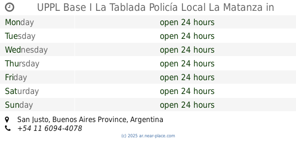
UPPL Base I La Tablada Policía Local La Matanza
San Justo
Local government office
read more
📑
all categories
Accounting
Administrative area level 1
Administrative area level 2
Airport
Amusement park
Aquarium
Art gallery
Atm
Bakery
Bank
Bar
Beauty salon
Bicycle store
Book store
Bowling alley
Bus station
Cafe
Campground
Car dealer
Car rental
Car repair
Car wash
Casino
Cemetery
Church
City hall
Clothing store
Colloquial area
Convenience store
Country
Courthouse
Dentist
Department store
Doctor
Electrician
Electronics store
Embassy
Establishment
Finance
Fire station
Florist
Food
Funeral home
Furniture store
Gas station
General contractor
Grocery or supermarket
Gym
Hair care
Hardware store
Health
Hindu Temple
Home goods store
Hospital
Insurance agency
Intersection
Jewelry store
Laundry
Lawyer
Library
Light rail station
Liquor store
Local government office
Locality
Locksmith
Lodging
Meal delivery
Meal takeaway
Mosque
Movie rental
Movie theater
Moving company
Museum
Natural feature
Neighborhood
Night club
Painter
Park
Parking
Pet store
Pharmacy
Physiotherapist
Place of worship
Plumber
Point of interest
Police
Political
Post office
Premise
Real estate agency
Restaurant
Roofing contractor
Route
Rv park, camping
School
Shoe store
Shopping mall
Spa
Stadium
Storage
Store
Subpremise
Subway station
Supermarket
Synagogue
Taxi stand
Train station
Transit station
Travel agency
University
Veterinary care
Zoo
sublocality level 1
sublocality level 3
↑