Local government office nearby Hospital
Argentina
Local government office nearby Hospital
Hospital
380, Avenida Acoyte, C1405BGO, Comuna 6, Buenos Aires, AR Argentina
contacts phone
:
+54
Latitude:
-34.6141022
, Longitude:
-58.4378641
larger map & directions
read more
nearest Local government office
426 m
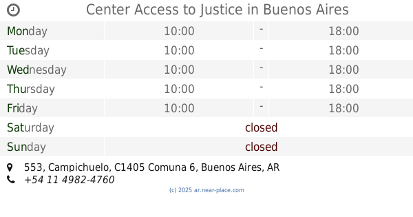
Center Access to Justice
Campichuelo 553
Local government office
read more
491 m
Subte A ACOYTE
Avenida Rivadavia 5000
Local government office
read more
700 m
Subte A PRIMERA JUNTA
Avenida Rivadavia 5300
Local government office
read more
858 m
CENTRO COMUNAL DELEGACION MELCHOR ROMERO
Calle 169 N° 1321, La Plata
Local government office
read more
872 m
Subte A RIO DE JANEIRO
Avenida Rivadavia 4500
Local government office
read more
877 m
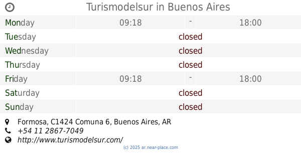
Turismodelsur
Formosa
Local government office
read more
891 m
Dpto Fer Zazo
C1405DCX, Avenida Díaz Vélez 5528
Local government office
read more
912 m
Estación Saludable
Local government office
read more
1.015 km
CEMET Gainza
General Martín de Gainza 1032
Local government office
read more
1.155 km
Telefonica de Argentina
Espinosa 46
Local government office
read more
1.157 km
Buenos Aires Consulta de establecimientos
Avenida Angel Gallardo 246
Local government office
read more
1.434 km
Subte A PUAN
Avenida Rivadavia 5900
Local government office
read more
1.437 km
Subte B ANGEL GALLARDO
Avenida Corrientes 4700
Local government office
read more
1.587 km
OBSBA municipales
C1406CUA, Miró 51
Local government office
read more
1.589 km
Subte A CASTRO BARROS
Avenida Rivadavia 3900
Local government office
read more
1.63 km
Araña Equipamientos 4x4 y utilitarios
Avenida Warnes 675, Villa Crespo
Local government office
read more
1.682 km
Subte B MALABIA - OSVALDO PUGLIESE
Avenida Corrientes 5300
Local government office
read more
1.756 km
Subte E AV. LA PLATA
Avenida Directorio 1
Local government office
read more
1.842 km
Subte E EMILIO MITRE
Emilio Mitre 700
Local government office
read more
1.856 km
Trenes De Carga
C1406GBF, Bogotá 1776-1800
Local government office
read more
1.868 km
ISC Instituto Superior de la Carrera
Zuviría 64
Local government office
read more
1.883 km
Agencia de Sistemas de Información - Gobierno de la Ciudad de Buenos Aires
C1424CKB, Zuviría 64
Local government office
read more
1.973 km
Subte B ALMAGRO - MEDRANO
Avenida Corrientes 4000
Local government office
read more
1.976 km
Direccion Nacional de los Registros Nacionales de la Propiedad del Automotor y de Creditos Prendarios
Avenida Directorio 1380
Local government office
read more
2.173 km
INSSSEP Instituto de Seguridad Social Seguros y Prestamos
Sarmiento 3653
Local government office
read more
📑
all categories
Accounting
Administrative area level 1
Administrative area level 2
Airport
Amusement park
Aquarium
Art gallery
Atm
Bakery
Bank
Bar
Beauty salon
Bicycle store
Book store
Bowling alley
Bus station
Cafe
Campground
Car dealer
Car rental
Car repair
Car wash
Casino
Cemetery
Church
City hall
Clothing store
Colloquial area
Convenience store
Country
Courthouse
Dentist
Department store
Doctor
Electrician
Electronics store
Embassy
Establishment
Finance
Fire station
Florist
Food
Funeral home
Furniture store
Gas station
General contractor
Grocery or supermarket
Gym
Hair care
Hardware store
Health
Hindu Temple
Home goods store
Hospital
Insurance agency
Intersection
Jewelry store
Laundry
Lawyer
Library
Light rail station
Liquor store
Local government office
Locality
Locksmith
Lodging
Meal delivery
Meal takeaway
Mosque
Movie rental
Movie theater
Moving company
Museum
Natural feature
Neighborhood
Night club
Painter
Park
Parking
Pet store
Pharmacy
Physiotherapist
Place of worship
Plumber
Point of interest
Police
Political
Post office
Premise
Real estate agency
Restaurant
Roofing contractor
Route
Rv park, camping
School
Shoe store
Shopping mall
Spa
Stadium
Storage
Store
Subpremise
Subway station
Supermarket
Synagogue
Taxi stand
Train station
Transit station
Travel agency
University
Veterinary care
Zoo
sublocality level 1
sublocality level 3
↑