Lodging nearby agilas las moras 4700
Argentina
Lodging nearby agilas las moras 4700
agilas las moras 4700
4700, Avenida Corrientes, C1414, Comuna 5, Buenos Aires, AR Argentina
contacts phone
:
+54 47454278
Latitude:
-34.602107
, Longitude:
-58.4321715
larger map & directions
read more
nearest Lodging
477 m
StudiosCYPE
C1199ABH, Presidente Teniente General Juan Domingo Perón 4450
Lodging
read more
551 m
PH Urbano
957 Lavalleja B, Buenos Aires
Lodging
read more
576 m
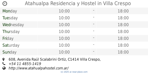
Atahualpa Residencia y Hostel
Avenida Raúl Scalabrini Ortíz 608, Villa Crespo
Lodging
read more
587 m
Lecer Apart
Teniente General Juan Domingo Perón 4301
Lodging
read more
614 m
Roman I
Avenida Estado de Israel 4354
Lodging
read more
630 m
Casrica
Avenida Estado de Israel 4349
Lodging
read more
639 m
Hotel Araoz
Aráoz 925
Lodging
read more
713 m
Corrientes Petit
Avenida Corrientes 4215, Buenos Aires
Lodging
read more
721 m
Casa De Giussi
Av. Warnes 302-206, C1414AAP
Lodging
read more
790 m
Acuario
Gascón 553
Lodging
read more
835 m
Rancho Urbano
Avenida Corrientes 4139
Lodging
read more
857 m
Hotel Pama 1
Avenida Corrientes 4118
Lodging
read more
865 m
Loft Almagro
Pringles 288, 6B
Lodging
read more
926 m
Hotel Río
Avenida Díaz Vélez 4169
Lodging
read more
956 m
Casa
Francisco Acuña de Figueroa 945, C1180AAQ
Lodging
read more
977 m
Hogar Asac
3988, Teniente General Juan Domingo Perón
Lodging
read more
1.026 km
Departamento Bs As Italiano
C1180AAD, Francisco Acuña de Figueroa 296
Lodging
read more
1.075 km
Hotel Los Nietos Familiar
Avenida Díaz Vélez 4011
Lodging
read more
1.083 km
Hostel de la Liberté
Lavalleja 1352
Lodging
read more
1.098 km
Hotel El Sol
Potosí 3946
Lodging
read more
1.134 km
Hotel Bys Palermo
Francisco Acuña de Figueroa 1263
Lodging
read more
1.144 km
Díaz Vélez
Avenida Díaz Vélez 3988
Lodging
read more
1.185 km
Thames y Aguirre
Thames 819
Lodging
read more
1.251 km
Yosemite
Vera 1039
Lodging
read more
1.295 km
Dto Villa Crespo
Villarroel 1047
Lodging
read more
📑
all categories
Accounting
Administrative area level 1
Administrative area level 2
Airport
Amusement park
Aquarium
Art gallery
Atm
Bakery
Bank
Bar
Beauty salon
Bicycle store
Book store
Bowling alley
Bus station
Cafe
Campground
Car dealer
Car rental
Car repair
Car wash
Casino
Cemetery
Church
City hall
Clothing store
Colloquial area
Convenience store
Country
Courthouse
Dentist
Department store
Doctor
Electrician
Electronics store
Embassy
Establishment
Finance
Fire station
Florist
Food
Funeral home
Furniture store
Gas station
General contractor
Grocery or supermarket
Gym
Hair care
Hardware store
Health
Hindu Temple
Home goods store
Hospital
Insurance agency
Intersection
Jewelry store
Laundry
Lawyer
Library
Light rail station
Liquor store
Local government office
Locality
Locksmith
Lodging
Meal delivery
Meal takeaway
Mosque
Movie rental
Movie theater
Moving company
Museum
Natural feature
Neighborhood
Night club
Painter
Park
Parking
Pet store
Pharmacy
Physiotherapist
Place of worship
Plumber
Point of interest
Police
Political
Post office
Premise
Real estate agency
Restaurant
Roofing contractor
Route
Rv park, camping
School
Shoe store
Shopping mall
Spa
Stadium
Storage
Store
Subpremise
Subway station
Supermarket
Synagogue
Taxi stand
Train station
Transit station
Travel agency
University
Veterinary care
Zoo
sublocality level 1
sublocality level 3
↑