Lodging nearby Cecill Pedersen
Argentina
Lodging nearby Cecill Pedersen
Cecill Pedersen
Salta, Argentina
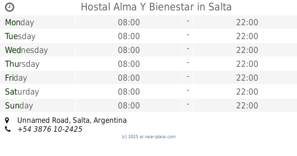
contacts phone
:
+54
Latitude:
-24.8527312
, Longitude:
-65.4391625
larger map & directions
read more
nearest Lodging
808 m
Casa de las NONAS
Diario la Voz del Interior 2909, Salta
Lodging
read more
981 m
apart wilson
Radio Nacional, Salta
Lodging
read more
1.043 km
*NEW* Hermoso Apartamento
Juan E. Marocco 2023-2001, Salta
Lodging
read more
1.317 km
Buscar Hostal En Guenes
Juan E. Marocco, Salta
Lodging
read more
1.828 km
Hotel Aybal
Ruta 51- Km 2, Av. Kennedy 2000, Salta
Lodging
read more
1.831 km
Opcion 1 Hotel Aybal
Avenida John F. Kennedy, Salta
Lodging
read more
1.955 km
Apart Aeropuerto Salta
Ruta Nacional 51, Salta
Lodging
read more
2.423 km
Hostal Alma Y Bienestar
Unnamed Road
Lodging
read more
2.56 km
Residencia Geriatrica Hostal del Campo
Rn 51Km 3, Salta
Lodging
read more
3.827 km
Finca los tres changos
Calle 138, Salta
Lodging
read more
3.845 km
Cabañas Rancho Alegre
Cerrillos
Lodging
read more
4.121 km
Motel Burbujas
Ruta 26, Salta
Lodging
read more
4.132 km
Sergio Alojamiento
Parque Nacional Los Cardones 3289, Salta
Lodging
read more
4.163 km
Silvia Isea
Salta
Lodging
read more
4.239 km
Motel Pasión
Ruta Provincial 26, Salta
Lodging
read more
4.36 km
Motel Siloe
Gato y Mancha, Salta
Lodging
read more
4.386 km
El Castillo
Ruta 26, Salta
Lodging
read more
4.392 km
Motel Géminis
Salta
Lodging
read more
4.552 km
Solis Pizarro
3058,, El Cóndor, Salta
Lodging
read more
4.622 km
Complejo Arenales
Avenida República del Líbano 650, Salta
Lodging
read more
4.954 km
Villa Esmeralda
clara juares de 3498
Lodging
read more
5.123 km
Casa vacacional
Julio Espinoza 1338, Salta
Lodging
read more
5.516 km
HOSTERIA EL PORTAL DE CERRILLOS
Cerrillos
Lodging
read more
6.191 km
Hostal Del Milagro
1001, Avenida Independencia, Salta
Lodging
read more
6.303 km
Hostel Gauchos Blackpakers Salta
Goyechea 1385, Salta
Lodging
read more
📑
all categories
Accounting
Administrative area level 1
Administrative area level 2
Airport
Amusement park
Aquarium
Art gallery
Atm
Bakery
Bank
Bar
Beauty salon
Bicycle store
Book store
Bowling alley
Bus station
Cafe
Campground
Car dealer
Car rental
Car repair
Car wash
Casino
Cemetery
Church
City hall
Clothing store
Colloquial area
Convenience store
Country
Courthouse
Dentist
Department store
Doctor
Electrician
Electronics store
Embassy
Establishment
Finance
Fire station
Florist
Food
Funeral home
Furniture store
Gas station
General contractor
Grocery or supermarket
Gym
Hair care
Hardware store
Health
Hindu Temple
Home goods store
Hospital
Insurance agency
Intersection
Jewelry store
Laundry
Lawyer
Library
Light rail station
Liquor store
Local government office
Locality
Locksmith
Lodging
Meal delivery
Meal takeaway
Mosque
Movie rental
Movie theater
Moving company
Museum
Natural feature
Neighborhood
Night club
Painter
Park
Parking
Pet store
Pharmacy
Physiotherapist
Place of worship
Plumber
Point of interest
Police
Political
Post office
Premise
Real estate agency
Restaurant
Roofing contractor
Route
Rv park, camping
School
Shoe store
Shopping mall
Spa
Stadium
Storage
Store
Subpremise
Subway station
Supermarket
Synagogue
Taxi stand
Train station
Transit station
Travel agency
University
Veterinary care
Zoo
sublocality level 1
sublocality level 3
↑