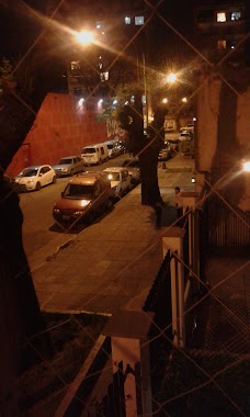
Lodging nearby San Martin de Los Andes
Argentina
Lodging nearby San Martin de Los Andes
San Martin de Los Andes
5272, Nahuel Huapi, C1431, Comuna 12, Buenos Aires, AR Argentina
contacts phone
:
+54
Latitude:
-34.5725352
, Longitude:
-58.4910593
larger map & directions
read more
nearest Lodging
155 m
Hospedaje Saavedra
Doctor Pedro Ignacio Rivera
Lodging
read more
329 m
Hotel Eiffel
Franklin D. Roosevelt 5149
Lodging
read more
447 m
Ker Urquiza Hotel & Suites
Díaz Colodrero 2513
Lodging
read more
448 m
Pasajeros Hotel Familiar
Bucarelli 2383
Lodging
read more
562 m
CONDOMINIOS EL POTO
C1431AEL, Iberá 5160
Lodging
read more
650 m
Habitacion Villa Urquiza
Avenida Olazábal 5172
Lodging
read more
682 m
Jardines de Roosevelt
C1431ERC, Aizpurúa 2501-2599
Lodging
read more
714 m
Aispuruba
Nahuel Huapi 5816
Lodging
read more
722 m
Hotel Casablanca
Avenida Álvarez Thomas 3190
Lodging
read more
755 m
Hostal Cullen
C1431BXU, Cullen 5849
Lodging
read more
757 m
Hotel Homelite
C1431ELQ, Ceretti 3265
Lodging
read more
807 m
Casa De Silvana
C1431ECO, Altolaguirre 2121, Buenos Aires
Lodging
read more
879 m
Paseo Del Arco Iris
Villa Urquiza
Lodging
read more
893 m
Consorcio Barzana
Barzana 2057, C1431EAM
Lodging
read more
899 m
Miller Loft
Miller 3154
Lodging
read more
899 m
Lola
Iberá 4730
Lodging
read more
912 m
Hotel Zeta
Avenida Congreso 4569
Lodging
read more
929 m
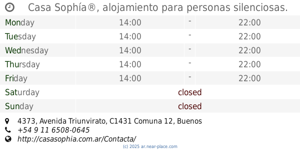
Casa Sophía®, alojamiento para personas silenciosas.
Avenida Triunvirato 4373
Lodging
read more
1.009 km
Susan Hotel
Avenida Monroe 4525
Lodging
read more
1.062 km
Radical
Lugones 1739
Lodging
read more
1.08 km
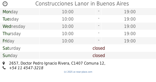
Construcciones Lanor
Doctor Pedro Ignacio Rivera 2657
Lodging
read more
1.366 km
Nueva Era
Plaza 3030, Buenos Aires
Lodging
read more
1.393 km
Torre De Gabriela Mistral
C1419GFH, Gabriela Mistral 2482
Lodging
read more
1.888 km
Erri Berri
Belgrado 3018
Lodging
read more
2.051 km
Altos de Agronomía
Barzana 1249
Lodging
read more
📑
all categories
Accounting
Administrative area level 1
Administrative area level 2
Airport
Amusement park
Aquarium
Art gallery
Atm
Bakery
Bank
Bar
Beauty salon
Bicycle store
Book store
Bowling alley
Bus station
Cafe
Campground
Car dealer
Car rental
Car repair
Car wash
Casino
Cemetery
Church
City hall
Clothing store
Colloquial area
Convenience store
Country
Courthouse
Dentist
Department store
Doctor
Electrician
Electronics store
Embassy
Establishment
Finance
Fire station
Florist
Food
Funeral home
Furniture store
Gas station
General contractor
Grocery or supermarket
Gym
Hair care
Hardware store
Health
Hindu Temple
Home goods store
Hospital
Insurance agency
Intersection
Jewelry store
Laundry
Lawyer
Library
Light rail station
Liquor store
Local government office
Locality
Locksmith
Lodging
Meal delivery
Meal takeaway
Mosque
Movie rental
Movie theater
Moving company
Museum
Natural feature
Neighborhood
Night club
Painter
Park
Parking
Pet store
Pharmacy
Physiotherapist
Place of worship
Plumber
Point of interest
Police
Political
Post office
Premise
Real estate agency
Restaurant
Roofing contractor
Route
Rv park, camping
School
Shoe store
Shopping mall
Spa
Stadium
Storage
Store
Subpremise
Subway station
Supermarket
Synagogue
Taxi stand
Train station
Transit station
Travel agency
University
Veterinary care
Zoo
sublocality level 1
sublocality level 3
↑