Meal takeaway nearby Ghetto 216
Argentina
Meal takeaway nearby Ghetto 216
Ghetto 216
216, Báez, C1426BRF, Comuna 14, Buenos Aires, AR Argentina
contacts phone
:
+54 11 2061-1308
Latitude:
-34.572597
, Longitude:
-58.430251
larger map & directions
read more
nearest Meal takeaway
57 m
SushiClub Las Cañitas
Báez 268
Meal takeaway
read more
201 m
Todo Brasa
Arévalo 2725
Meal takeaway
read more
343 m
Girgola TakeAway - Comida Casera & Saludable
Báez 504
Meal takeaway
read more
346 m
Ocio
Arce 499
Meal takeaway
read more
350 m
Roticería La Radice
Báez 540
Meal takeaway
read more
539 m
Veganius
Bonpland 2444
Meal takeaway
read more
616 m
Rotisería
Migueletes 623
Meal takeaway
read more
665 m
Bar Mario
Humboldt 2485
Meal takeaway
read more
731 m
La Tana
Charcas 5015
Meal takeaway
read more
750 m
Lucky Dragon
Charcas 5002
Meal takeaway
read more
755 m
Sösich
Migueletes 796
Meal takeaway
read more
755 m
COTTON-Sösich Haute Dogs
Migueletes 796
Meal takeaway
read more
766 m
Lo de las Chicas
Godoy Cruz 2880
Meal takeaway
read more
868 m
TOMASSO
Avenida Santa Fe 4564
Meal takeaway
read more
875 m
Tercera Docena
C1425FVC, Fitz Roy 2203
Meal takeaway
read more
875 m
tercera docena empanadas
C1425FVC, Fitz Roy 2203
Meal takeaway
read more
910 m
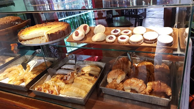
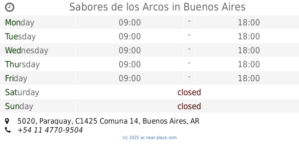
Sabores de los Arcos
Paraguay 5020
Meal takeaway
read more
917 m
Delicias en los Arcos
Paraguay 5020
Meal takeaway
read more
948 m
SushiClub Belgrano - Nuñez (Deli & Take)
BUK, Migueletes 989
Meal takeaway
read more
1.015 km
La Pulpería de Francisco
Arévalo 1951
Meal takeaway
read more
1.017 km
Rotiseria Tom
Darregueyra 2476
Meal takeaway
read more
1.065 km
In Bocca al Lupo
Bonpland 1965
Meal takeaway
read more
1.213 km
La Cocina Delivery
Av Federico Lacroze 1830 B
Meal takeaway
read more
1.558 km
Don Isidoro
Gorriti 5481
Meal takeaway
read more
2.125 km
Faricci
Julián Álvarez 2097
Meal takeaway
read more
📑
all categories
Accounting
Administrative area level 1
Administrative area level 2
Airport
Amusement park
Aquarium
Art gallery
Atm
Bakery
Bank
Bar
Beauty salon
Bicycle store
Book store
Bowling alley
Bus station
Cafe
Campground
Car dealer
Car rental
Car repair
Car wash
Casino
Cemetery
Church
City hall
Clothing store
Colloquial area
Convenience store
Country
Courthouse
Dentist
Department store
Doctor
Electrician
Electronics store
Embassy
Establishment
Finance
Fire station
Florist
Food
Funeral home
Furniture store
Gas station
General contractor
Grocery or supermarket
Gym
Hair care
Hardware store
Health
Hindu Temple
Home goods store
Hospital
Insurance agency
Intersection
Jewelry store
Laundry
Lawyer
Library
Light rail station
Liquor store
Local government office
Locality
Locksmith
Lodging
Meal delivery
Meal takeaway
Mosque
Movie rental
Movie theater
Moving company
Museum
Natural feature
Neighborhood
Night club
Painter
Park
Parking
Pet store
Pharmacy
Physiotherapist
Place of worship
Plumber
Point of interest
Police
Political
Post office
Premise
Real estate agency
Restaurant
Roofing contractor
Route
Rv park, camping
School
Shoe store
Shopping mall
Spa
Stadium
Storage
Store
Subpremise
Subway station
Supermarket
Synagogue
Taxi stand
Train station
Transit station
Travel agency
University
Veterinary care
Zoo
sublocality level 1
sublocality level 3
↑