Night club nearby Cochera
Argentina
Night club nearby Cochera
Cochera
1956, Adolfo Alsina, C1090, Comuna 3, Buenos Aires, AR Argentina
contacts phone
:
+54
Latitude:
-34.611827
, Longitude:
-58.3940633
larger map & directions
read more
nearest Night club
259 m
Fiesta La Warhol
C1033AAW, Avenida Rivadavia 1910
Night club
read more
266 m
BREAK TNGRS
C1033AAW, Avenida Rivadavia 1906
Night club
read more
279 m
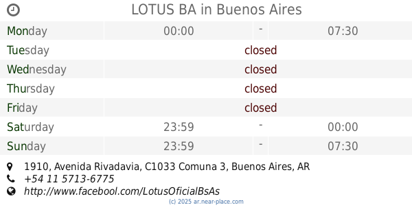
LOTUS BA
C1033AAW, Avenida Rivadavia 1910
Night club
read more
607 m
Li Feng
Presidente Luis Sáenz Peña 127, Congreso
Night club
read more
612 m
HUANG HE - VIGOR VIRIL
Presidente Luis Sáenz Peña 127, Congreso
Night club
read more
617 m
AndroPenis
Presidente Luis Sáenz Peña 127, Plaza Congreso
Night club
read more
617 m
Xing Yu
Presidente Luis Sáenz Peña 127, Plaza Congreso
Night club
read more
719 m
PR
C1042ABH, Sarmiento 1780-1800
Night club
read more
728 m
Puerto Rico
C1042ABH, Sarmiento 1750, Buenos Aires
Night club
read more
738 m
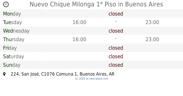
Nuevo Chique Milonga 1* Piso
C1076AAF, San José 224
Night club
read more
739 m
WAX Buenos Aires
C1042ABH, ABH, Sarmiento 1728, Buenos Aires
Night club
read more
744 m
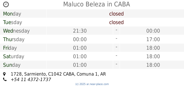
Maluco Beleza
Sarmiento 1728, CABA
Night club
read more
744 m
Maluco Beleza
Sarmiento 1728
Night club
read more
749 m
WAX V.I.P
Sarmiento 1727
Night club
read more
751 m
Porteño Y Bailarín
,C1025ABG, Riobamba 345, Buenos Aires
Night club
read more
782 m
Mystique
Sarmiento 1662, 1042 Buenos Aires
Night club
read more
847 m
Discoteca El Palacio del Sandwich
Night club
read more
857 m
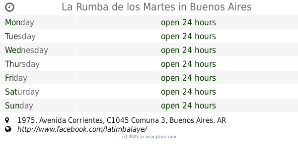
La Rumba de los Martes
Avenida Corrientes 1975
Night club
read more
890 m
Terraza Pasteur 362
Pasteur 362
Night club
read more
908 m
Discoteca Bar Amigo
Night club
read more
914 m
Caba
Estados Unidos 2140
Night club
read more
947 m
PEGAO
Estados Unidos 1560 C1101ABF
Night club
read more
956 m
Meganight Fest
Presidente Teniente General Juan Domingo Perón 1372
Night club
read more
971 m
Mis Angelitos Mayorista
C1029AAG, Azcuénaga 371
Night club
read more
1.115 km
Pv Talca
Talcahuano 308, Buenos Aires
Night club
read more
📑
all categories
Accounting
Administrative area level 1
Administrative area level 2
Airport
Amusement park
Aquarium
Art gallery
Atm
Bakery
Bank
Bar
Beauty salon
Bicycle store
Book store
Bowling alley
Bus station
Cafe
Campground
Car dealer
Car rental
Car repair
Car wash
Casino
Cemetery
Church
City hall
Clothing store
Colloquial area
Convenience store
Country
Courthouse
Dentist
Department store
Doctor
Electrician
Electronics store
Embassy
Establishment
Finance
Fire station
Florist
Food
Funeral home
Furniture store
Gas station
General contractor
Grocery or supermarket
Gym
Hair care
Hardware store
Health
Hindu Temple
Home goods store
Hospital
Insurance agency
Intersection
Jewelry store
Laundry
Lawyer
Library
Light rail station
Liquor store
Local government office
Locality
Locksmith
Lodging
Meal delivery
Meal takeaway
Mosque
Movie rental
Movie theater
Moving company
Museum
Natural feature
Neighborhood
Night club
Painter
Park
Parking
Pet store
Pharmacy
Physiotherapist
Place of worship
Plumber
Point of interest
Police
Political
Post office
Premise
Real estate agency
Restaurant
Roofing contractor
Route
Rv park, camping
School
Shoe store
Shopping mall
Spa
Stadium
Storage
Store
Subpremise
Subway station
Supermarket
Synagogue
Taxi stand
Train station
Transit station
Travel agency
University
Veterinary care
Zoo
sublocality level 1
sublocality level 3
↑