Night club nearby Don Cuerno Drones
Argentina
Night club nearby Don Cuerno Drones
Don Cuerno Drones
3282, Salcedo, C1259, Comuna 4, Buenos Aires, AR Argentina
contacts phone
:
+54
Latitude:
-34.6329666
, Longitude:
-58.4111127
larger map & directions
read more
nearest Night club
244 m
Home Estudio Poxy Records
Salcedo 3115
Night club
read more
255 m
CABARULO
Salcedo 3101, C1259ABK
Night club
read more
282 m
El Tanke
C1260ABN, Avenida Brasil 3168
Night club
read more
539 m
Las Torres de Salcedo (Lts)
Night club
read more
566 m
Las Lunas y Las Otras
Maza 1492
Night club
read more
635 m
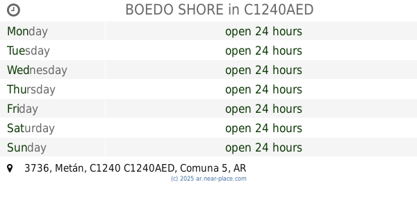
BOEDO SHORE
Metán 3736, C1240AED
Night club
read more
766 m
Casa De Nala
C1243, Cochabamba 3155
Night club
read more
783 m
Salas Acuario
C1258ABG, Inclán 3921
Night club
read more
798 m
Salón Tres Deseos
Esteban de Luca 1639
Night club
read more
894 m
Teatro La Comuna
C1437EYA, Zavaleta 72
Night club
read more
923 m
Balcon
General Urquiza 1202-1248
Night club
read more
1.016 km
Club De Ajedrez Luz Y Fuerza
Deán Funes 672, Córdoba
Night club
read more
1.049 km
Super Casa Boedo
Avenida Boedo 923
Night club
read more
1.05 km
Dame Tu Bachata (La NUEVA Casona)
Avenida San Juan 2926
Night club
read more
1.05 km
Club Gricel
Night club
read more
1.082 km
Rivadavia y Pueyrredon
Quintino Bocayuva 1241 C1257ABC
Night club
read more
1.112 km
La Cantera ONG
Uspallata 3832, C1437JCZ
Night club
read more
1.127 km
Cancha Huracan
Night club
read more
1.321 km
La Nueva Casona Vip
Avenida San Juan 4112
Night club
read more
1.489 km
Vivienda Social
C1284AEC, Monasterio 171
Night club
read more
1.808 km
casa de ferrugen
Rincón 1282, C1251ACB
Night club
read more
2.167 km
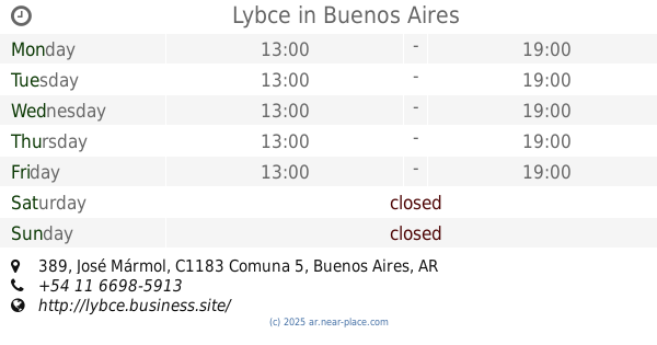
Lybce
José Mármol 389
Night club
read more
2.25 km
Feliz Lunes Milonga
C1080ABR, Avenida Entre Ríos 1056, Buenos Aires
Night club
read more
2.578 km
Albialum
Avenida General Francisco Fernández de la Cruz 1680
Night club
read more
2.613 km
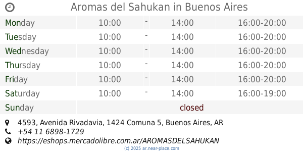
Aromas del Sahukan
Avenida Rivadavia 4593
Night club
read more
📑
all categories
Accounting
Administrative area level 1
Administrative area level 2
Airport
Amusement park
Aquarium
Art gallery
Atm
Bakery
Bank
Bar
Beauty salon
Bicycle store
Book store
Bowling alley
Bus station
Cafe
Campground
Car dealer
Car rental
Car repair
Car wash
Casino
Cemetery
Church
City hall
Clothing store
Colloquial area
Convenience store
Country
Courthouse
Dentist
Department store
Doctor
Electrician
Electronics store
Embassy
Establishment
Finance
Fire station
Florist
Food
Funeral home
Furniture store
Gas station
General contractor
Grocery or supermarket
Gym
Hair care
Hardware store
Health
Hindu Temple
Home goods store
Hospital
Insurance agency
Intersection
Jewelry store
Laundry
Lawyer
Library
Light rail station
Liquor store
Local government office
Locality
Locksmith
Lodging
Meal delivery
Meal takeaway
Mosque
Movie rental
Movie theater
Moving company
Museum
Natural feature
Neighborhood
Night club
Painter
Park
Parking
Pet store
Pharmacy
Physiotherapist
Place of worship
Plumber
Point of interest
Police
Political
Post office
Premise
Real estate agency
Restaurant
Roofing contractor
Route
Rv park, camping
School
Shoe store
Shopping mall
Spa
Stadium
Storage
Store
Subpremise
Subway station
Supermarket
Synagogue
Taxi stand
Train station
Transit station
Travel agency
University
Veterinary care
Zoo
sublocality level 1
sublocality level 3
↑