Night club nearby La Calesita
Argentina
Night club nearby La Calesita
La Calesita
2974, Avenida Independencia, C1225, Comuna 3, Buenos Aires, AR Argentina
contacts phone
:
+54 11 6797-9940
Latitude:
-34.6197438
, Longitude:
-58.4073364
larger map & directions
read more
nearest Night club
102 m
Omnilife cuida tu salud
Avenida Independencia 2900, Buenos Aires
Night club
read more
387 m
UB Héroes de Malvinas
C1231ACH, Humberto 1º 2900
Night club
read more
488 m
Club Gricel
Night club
read more
488 m
La Mandrilera
C1229AAP, Humberto 1º 2758, C1229AAP
Night club
read more
528 m
Dame Tu Bachata (La NUEVA Casona)
Avenida San Juan 2926
Night club
read more
587 m
Balcon
General Urquiza 1202-1248
Night club
read more
601 m
Club De Ajedrez Luz Y Fuerza
Deán Funes 672, Córdoba
Night club
read more
634 m
La Mandrilera
C1229AAP, Humberto 1º 2578
Night club
read more
725 m
Parada Once Tdh
Moreno 2823
Night club
read more
747 m
Casa De Nala
C1243, Cochabamba 3155
Night club
read more
753 m
Discoteca El Abrojito
Chile 2349
Night club
read more
860 m
estilo moderno peluq
Avenida Boedo 514-600
Night club
read more
873 m
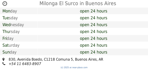
Milonga El Surco
Avenida Boedo 830
Night club
read more
878 m
Aves
Matheu 1222
Night club
read more
955 m
Noris
Avenida Hipólito Yrigoyen 3304
Night club
read more
980 m
Super Casa Boedo
Avenida Boedo 923
Night club
read more
984 m
Caba
Estados Unidos 2140
Night club
read more
1.006 km
Sofitel
Avenida Independencia 3719
Night club
read more
1.194 km
Las Lunas y Las Otras
Maza 1492
Night club
read more
1.344 km
Acatraz
Avenida Rivadavia 3636
Night club
read more
1.542 km
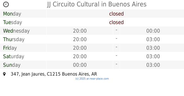
JJ Circuito Cultural
Jean Jaures 347
Night club
read more
1.77 km
Terraza Pasteur 362
Pasteur 362
Night club
read more
1.947 km
PEÑA LA ULTIMITA
Presidente Luis Sáenz Peña 1442
Night club
read more
2.135 km
Puerto Rico
C1042ABH, Sarmiento 1750, Buenos Aires
Night club
read more
2.156 km
WAX Buenos Aires
C1042ABH, ABH, Sarmiento 1728, Buenos Aires
Night club
read more
📑
all categories
Accounting
Administrative area level 1
Administrative area level 2
Airport
Amusement park
Aquarium
Art gallery
Atm
Bakery
Bank
Bar
Beauty salon
Bicycle store
Book store
Bowling alley
Bus station
Cafe
Campground
Car dealer
Car rental
Car repair
Car wash
Casino
Cemetery
Church
City hall
Clothing store
Colloquial area
Convenience store
Country
Courthouse
Dentist
Department store
Doctor
Electrician
Electronics store
Embassy
Establishment
Finance
Fire station
Florist
Food
Funeral home
Furniture store
Gas station
General contractor
Grocery or supermarket
Gym
Hair care
Hardware store
Health
Hindu Temple
Home goods store
Hospital
Insurance agency
Intersection
Jewelry store
Laundry
Lawyer
Library
Light rail station
Liquor store
Local government office
Locality
Locksmith
Lodging
Meal delivery
Meal takeaway
Mosque
Movie rental
Movie theater
Moving company
Museum
Natural feature
Neighborhood
Night club
Painter
Park
Parking
Pet store
Pharmacy
Physiotherapist
Place of worship
Plumber
Point of interest
Police
Political
Post office
Premise
Real estate agency
Restaurant
Roofing contractor
Route
Rv park, camping
School
Shoe store
Shopping mall
Spa
Stadium
Storage
Store
Subpremise
Subway station
Supermarket
Synagogue
Taxi stand
Train station
Transit station
Travel agency
University
Veterinary care
Zoo
sublocality level 1
sublocality level 3
↑