Park nearby Plazoleta Skanderberg
Argentina
Park nearby Plazoleta Skanderberg
Plazoleta Skanderberg
3102-3150, Cristóbal M. Hicken, C1439, Comuna 8, Buenos Aires, AR Argentina
contacts phone
:
+54
Latitude:
-34.6680493
, Longitude:
-58.4816334
larger map & directions
read more
nearest Park
304 m
Plaza Larraya
Villa Lugano
Park
read more
307 m
Emilio Troncoso
C1439BIB, Ingeniero Enrique Hermitte 5402-5500
Park
read more
317 m
Plazoleta Bernardo B. Delom
Villa de Masnou 3352-3400
Park
read more
317 m
Bernardo B. Delom
Villa de Masnou 3352-3400
Park
read more
550 m
Cedi Copello
C1439EPP, Miralla 3300
Park
read more
876 m
Sala de Juegos Conviven
Martiniano Leguizamón 2964, C1439FRB
Park
read more
938 m
Plaza
Villa Lugano
Park
read more
1.004 km
Plaza Fray Pedro A. Cueli
Av. Argentina 5199
Park
read more
1.098 km
Plaza Unidad Nacional
Delfin Gallo 5746
Park
read more
1.543 km
Diputada Emar Acosta
C1440AYV, Avenida General Eugenio Garzón 5902-6000
Park
read more
1.594 km
Irma Carrica
Avenida San Juan Bautista de la Salle 2182-2200
Park
read more
1.599 km
Plazoleta Latino Americana
El Profeta de la Pampa 4701-4799
Park
read more
1.656 km
Depósito Judicial
José Pablo Torcuato Batlle y Ordóñez 4502-4850
Park
read more
1.744 km
Dr. Carlos S. Lamas
C1440EJT, Avenida Coronel Cárdenas 2820-2900
Park
read more
1.753 km
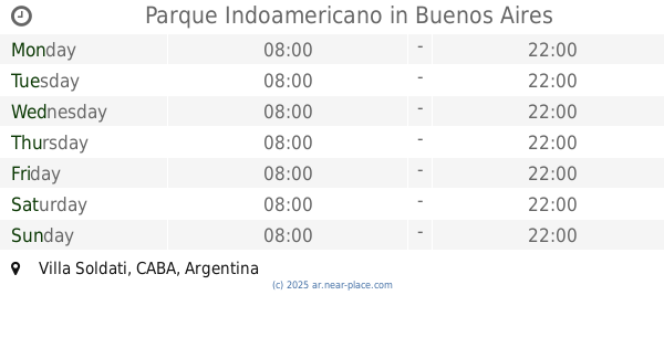
Parque Indoamericano
Villa Soldati
Park
read more
1.901 km
Aeronáutica Argentina
Avenida General Francisco Fernández de la Cruz 5433-5479
Park
read more
1.951 km
Via Verde
2298,, Agrelo 2200, La Tablada
Park
read more
1.954 km
Jacinto Oddone
Avenida Derqui 3901-3939
Park
read more
1.961 km
Las Mesitas de River
Villa Lugano
Park
read more
1.996 km
Parqué De Los Mataderos
Mataderos
Park
read more
2.138 km
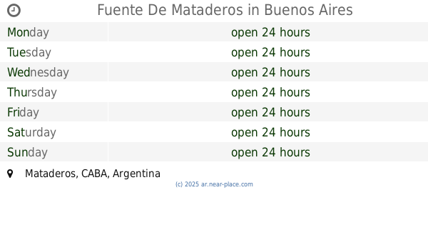
Fuente De Mataderos
Mataderos
Park
read more
2.168 km
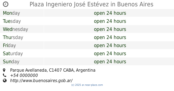
Plaza Ingeniero José Estévez
Parque Avellaneda
Park
read more
2.339 km
Plaza Jorge Di Pascuale
Park
read more
2.339 km
Plaza Jorge Di Pasquale
Park
read more
2.442 km
Parque de Las Victorias
Avenida Larrazábal 4880-4950
Park
read more
📑
all categories
Accounting
Administrative area level 1
Administrative area level 2
Airport
Amusement park
Aquarium
Art gallery
Atm
Bakery
Bank
Bar
Beauty salon
Bicycle store
Book store
Bowling alley
Bus station
Cafe
Campground
Car dealer
Car rental
Car repair
Car wash
Casino
Cemetery
Church
City hall
Clothing store
Colloquial area
Convenience store
Country
Courthouse
Dentist
Department store
Doctor
Electrician
Electronics store
Embassy
Establishment
Finance
Fire station
Florist
Food
Funeral home
Furniture store
Gas station
General contractor
Grocery or supermarket
Gym
Hair care
Hardware store
Health
Hindu Temple
Home goods store
Hospital
Insurance agency
Intersection
Jewelry store
Laundry
Lawyer
Library
Light rail station
Liquor store
Local government office
Locality
Locksmith
Lodging
Meal delivery
Meal takeaway
Mosque
Movie rental
Movie theater
Moving company
Museum
Natural feature
Neighborhood
Night club
Painter
Park
Parking
Pet store
Pharmacy
Physiotherapist
Place of worship
Plumber
Point of interest
Police
Political
Post office
Premise
Real estate agency
Restaurant
Roofing contractor
Route
Rv park, camping
School
Shoe store
Shopping mall
Spa
Stadium
Storage
Store
Subpremise
Subway station
Supermarket
Synagogue
Taxi stand
Train station
Transit station
Travel agency
University
Veterinary care
Zoo
sublocality level 1
sublocality level 3
↑