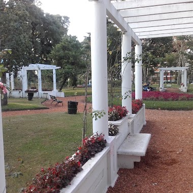
Park nearby Rosedal Parque Chacabuco
Argentina
Park nearby Rosedal Parque Chacabuco
Rosedal Parque Chacabuco
Autopista 25 de Mayo, C1424, Comuna 7, Buenos Aires, AR Argentina
contacts phone
:
+54
Latitude:
-34.6323745
, Longitude:
-58.4419173
larger map & directions
read more
nearest Park
47 m
Parque Chacabuco
Park
read more
160 m
Plazoleta Dr Avelino GUTIERREZ
C1424AYO, Emilio Mitre 793
Park
read more
259 m
Polideportivo Chacabuco Park
Avenida Eva Perón 1400
Park
read more
259 m
Parque Polideportivo Chacabuco
Avenida Eva Perón 1400
Park
read more
293 m
PLAZOLETA JOSE LUIS ROMERO
Parque Chacabuco
Park
read more
407 m
Parque Chacabuco
C1406HVA, Avenida Asamblea 1001-1077
Park
read more
407 m
Chacabuco Park
C1406HVA, Avenida Asamblea 1001-1077
Park
read more
449 m
Plaza Zuviría
Zuviría 834
Park
read more
455 m
Plaza Tochi
Park
read more
569 m
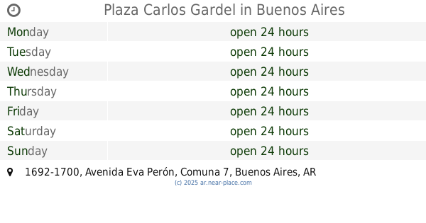
Plaza Carlos Gardel
Avenida Eva Perón 1692-1700
Park
read more
642 m
Milu Garden
Avenida Pedro Goyena 1043, C1424BSK
Park
read more
642 m
Jardin Milu
Avenida Pedro Goyena 1043, C1424BSK
Park
read more
725 m
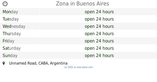
Zona
Unnamed Road
Park
read more
728 m
El Sensei Growshop - Caballito
Avenida Pedro Goyena 801, Buenos Aires
Park
read more
1.283 km
Plaza Antoine Saint-Exupéry
Park
read more
1.293 km
Primera Junta
C1424CEJ, Avenida Rivadavia 5409-5415
Park
read more
1.591 km
Colegio Numen Anexo Jardín
Yerbal 1871
Park
read more
1.65 km
Plazoleta Homero Manzi
C1437AAC, Avenida del Barco Centenera 2201-2287
Park
read more
1.719 km
Plaza Giordano Bruno
Parral, City of Buenos Aires
Park
read more
1.742 km
Plaza Bruno Giordano
C1405CHB, Giordano Bruno 702-800
Park
read more
1.765 km
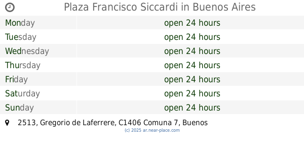
Plaza Francisco Siccardi
Gregorio de Laferrere 2513
Park
read more
1.805 km
Plazoleta Enrique Santos Discepolo
C1424DDA, Butteler 41-59
Park
read more
1.857 km
Paseo Sara Vaamonde
Avenida Independencia 4264
Park
read more
2.022 km
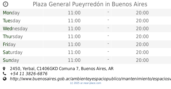
Plaza General Pueyrredón
Yerbal 2450
Park
read more
2.452 km
Canil Plaza Irlanda
Avenida Teniente General Donato Álvarez, Avenida Gaona y
Park
read more
📑
all categories
Accounting
Administrative area level 1
Administrative area level 2
Airport
Amusement park
Aquarium
Art gallery
Atm
Bakery
Bank
Bar
Beauty salon
Bicycle store
Book store
Bowling alley
Bus station
Cafe
Campground
Car dealer
Car rental
Car repair
Car wash
Casino
Cemetery
Church
City hall
Clothing store
Colloquial area
Convenience store
Country
Courthouse
Dentist
Department store
Doctor
Electrician
Electronics store
Embassy
Establishment
Finance
Fire station
Florist
Food
Funeral home
Furniture store
Gas station
General contractor
Grocery or supermarket
Gym
Hair care
Hardware store
Health
Hindu Temple
Home goods store
Hospital
Insurance agency
Intersection
Jewelry store
Laundry
Lawyer
Library
Light rail station
Liquor store
Local government office
Locality
Locksmith
Lodging
Meal delivery
Meal takeaway
Mosque
Movie rental
Movie theater
Moving company
Museum
Natural feature
Neighborhood
Night club
Painter
Park
Parking
Pet store
Pharmacy
Physiotherapist
Place of worship
Plumber
Point of interest
Police
Political
Post office
Premise
Real estate agency
Restaurant
Roofing contractor
Route
Rv park, camping
School
Shoe store
Shopping mall
Spa
Stadium
Storage
Store
Subpremise
Subway station
Supermarket
Synagogue
Taxi stand
Train station
Transit station
Travel agency
University
Veterinary care
Zoo
sublocality level 1
sublocality level 3
↑