Parking nearby Estacionamiento
Argentina
Parking nearby Estacionamiento
Estacionamiento
259, Necochea, B1704, Ramos Mejía, La Matanza, AR Argentina
contacts phone
:
+54
Latitude:
-34.6434309
, Longitude:
-58.5669514
larger map & directions
read more
nearest Parking
114 m
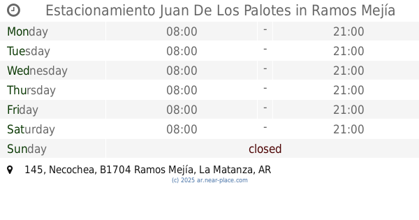
Estacionamiento Juan De Los Palotes
Necochea 145, Ramos Mejía
Parking
read more
172 m
Garage family
Belgrano 144, Ramos Mejía
Parking
read more
180 m
L' Palmeras Estacionamiento
Espora 207, Ramos Mejía
Parking
read more
197 m
ESTACIONAMIENTO RAMOS MEJÍA
Necochea 91, Gran Buenos Aires
Parking
read more
240 m
Garage Belgrani
Belgrano 356, Ramos Mejía
Parking
read more
270 m
Estacionamiento Castelli
Castelli 348,1704, Ramos Mejía
Parking
read more
280 m
Estacionamiento
B1704ETB, Belgrano 40, Ramos Mejía
Parking
read more
291 m
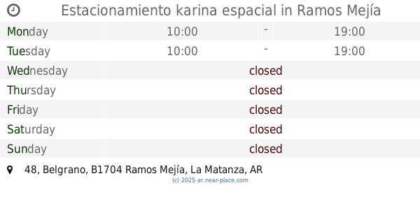
Estacionamiento karina espacial
Belgrano 48, Ramos Mejía
Parking
read more
323 m
Garage
Bolívar 344, Ramos Mejía
Parking
read more
405 m
Garage Moreno
Moreno 215, Gran Buenos Aires
Parking
read more
408 m
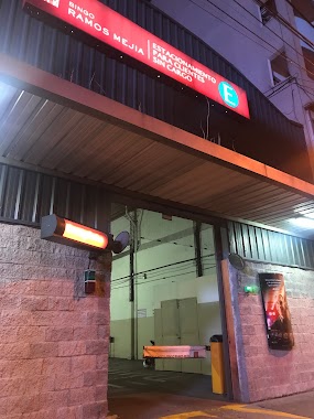
Estacionamiento Bingo Ramos Mejia
Belgrano 87, Ramos Mejía
Parking
read more
520 m
Estacionamiento Ramos Mejia
Bartolomé Mitre 177, Gran Buenos Aires
Parking
read more
525 m
SAIRAM
Bartolomé Mitre 148, Gran Buenos Aires
Parking
read more
612 m
Estacionamiento Mitre
Bartolomé Mitre 242, Gran Buenos Aires
Parking
read more
689 m
Estacionamiento
Villa Sarmiento
Parking
read more
800 m
Garage Rivadavia
Avenida Rivadavia 13636, Ramos Mejía
Parking
read more
1.039 km
Garaje Los 8 Hermanos
B1704DUA, Carlos Calvo 51, Ramos Mejía
Parking
read more
1.073 km
Estacionamiento
Doctor Gabriel Ardoino 640, Ramos Mejía
Parking
read more
1.148 km
Ward Est
Mayor Pedro Castelli 685, Villa Sarmiento
Parking
read more
1.205 km
Estacionamiento Charly
Sucre 47, Ramos Mejía
Parking
read more
1.565 km
Valet-Parking
Adolfo Alsina 833, Ciudadela
Parking
read more
1.983 km
Estacionamiento Cambiasso
Triunvirato 2047, Villa Luzuriaga
Parking
read more
2.405 km
Estacionamiento de Coto
Ciudadela
Parking
read more
2.908 km
Estacionamiento
San Justo
Parking
read more
3.484 km
Playón común de Escuelas
Ciudadela
Parking
read more
📑
all categories
Accounting
Administrative area level 1
Administrative area level 2
Airport
Amusement park
Aquarium
Art gallery
Atm
Bakery
Bank
Bar
Beauty salon
Bicycle store
Book store
Bowling alley
Bus station
Cafe
Campground
Car dealer
Car rental
Car repair
Car wash
Casino
Cemetery
Church
City hall
Clothing store
Colloquial area
Convenience store
Country
Courthouse
Dentist
Department store
Doctor
Electrician
Electronics store
Embassy
Establishment
Finance
Fire station
Florist
Food
Funeral home
Furniture store
Gas station
General contractor
Grocery or supermarket
Gym
Hair care
Hardware store
Health
Hindu Temple
Home goods store
Hospital
Insurance agency
Intersection
Jewelry store
Laundry
Lawyer
Library
Light rail station
Liquor store
Local government office
Locality
Locksmith
Lodging
Meal delivery
Meal takeaway
Mosque
Movie rental
Movie theater
Moving company
Museum
Natural feature
Neighborhood
Night club
Painter
Park
Parking
Pet store
Pharmacy
Physiotherapist
Place of worship
Plumber
Point of interest
Police
Political
Post office
Premise
Real estate agency
Restaurant
Roofing contractor
Route
Rv park, camping
School
Shoe store
Shopping mall
Spa
Stadium
Storage
Store
Subpremise
Subway station
Supermarket
Synagogue
Taxi stand
Train station
Transit station
Travel agency
University
Veterinary care
Zoo
sublocality level 1
sublocality level 3
↑