Restaurant nearby Champs Elysees
Argentina
Restaurant nearby Champs Elysees
Champs Elysees
Buenos Aires, Argentina
contacts phone
:
+54 11 4780-3249
Latitude:
-34.5471044
, Longitude:
-58.4475179
larger map & directions
read more
nearest Restaurant
361 m
Mariandy
C1428CFC, Rafael Hernández 2613
Restaurant
read more
535 m
Calle Fresca
Avenida Lidoro J. Quinteros 1297
Restaurant
read more
610 m
Morita
Avenida del Libertador 6739
Restaurant
read more
622 m
Galidón
Avenida Guillermo Udaondo 470
Restaurant
read more
626 m
Galidón
Avenida Guillermo Udaondo 1470, Barrio Nuñez
Restaurant
read more
640 m
El Club de La Milanesa
Avenida Monroe 1402, BKP
Restaurant
read more
714 m
Empanadas Carlos Matías Franco
Migueletes 2388
Restaurant
read more
762 m
Amarelo
Blanco Encalada 1481
Restaurant
read more
769 m
Amarelo
Avenida del Libertador 6301
Restaurant
read more
776 m
Baccano Ristorante Italiano
Avenida Congreso 1602
Restaurant
read more
784 m
Chef León
Montañeses 2698
Restaurant
read more
809 m
Mi Barrio Hamburguesería Belgrano
Olazábal 1422
Restaurant
read more
860 m
Casa Vegana
Montañeses 2494, C1428AQN
Restaurant
read more
885 m
NUN
Montañeses 3150
Restaurant
read more
976 m
PIZZA CAPONE
Avenida Monroe 1706
Restaurant
read more
997 m
Bodegón De Nuñez
Arribeños 3198, 1429BKH
Restaurant
read more
1.007 km
Taura Café&Bistro
Blanco Encalada 1699
Restaurant
read more
1.009 km
El Cisne Blanco (sucursal)
C1428AQI, Montañeses 2231
Restaurant
read more
1.051 km
Confitería Del Gimnasio athletia
C1429BSP, Avenida Crisólogo Larralde 1460
Restaurant
read more
1.059 km
Zheng Comida Oriental
Arribeños 2305 1428
Restaurant
read more
1.064 km
Garbis
11 de Septiembre 2517
Restaurant
read more
1.093 km
Deniro Hamburguesería
11 de Septiembre 2488
Restaurant
read more
1.108 km
Salon Ciudad
Avenida Crisólogo Larralde 1338
Restaurant
read more
1.117 km
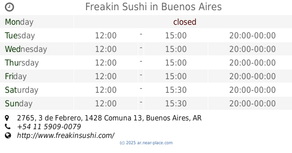
Freakin Sushi
3 de Febrero 2765, Buenos Aires
Restaurant
read more
1.195 km
Narda Comedor
C1428DUB, Mariscal Antonio José de Sucre 664
Restaurant
read more
📑
all categories
Accounting
Administrative area level 1
Administrative area level 2
Airport
Amusement park
Aquarium
Art gallery
Atm
Bakery
Bank
Bar
Beauty salon
Bicycle store
Book store
Bowling alley
Bus station
Cafe
Campground
Car dealer
Car rental
Car repair
Car wash
Casino
Cemetery
Church
City hall
Clothing store
Colloquial area
Convenience store
Country
Courthouse
Dentist
Department store
Doctor
Electrician
Electronics store
Embassy
Establishment
Finance
Fire station
Florist
Food
Funeral home
Furniture store
Gas station
General contractor
Grocery or supermarket
Gym
Hair care
Hardware store
Health
Hindu Temple
Home goods store
Hospital
Insurance agency
Intersection
Jewelry store
Laundry
Lawyer
Library
Light rail station
Liquor store
Local government office
Locality
Locksmith
Lodging
Meal delivery
Meal takeaway
Mosque
Movie rental
Movie theater
Moving company
Museum
Natural feature
Neighborhood
Night club
Painter
Park
Parking
Pet store
Pharmacy
Physiotherapist
Place of worship
Plumber
Point of interest
Police
Political
Post office
Premise
Real estate agency
Restaurant
Roofing contractor
Route
Rv park, camping
School
Shoe store
Shopping mall
Spa
Stadium
Storage
Store
Subpremise
Subway station
Supermarket
Synagogue
Taxi stand
Train station
Transit station
Travel agency
University
Veterinary care
Zoo
sublocality level 1
sublocality level 3
↑