Restaurant nearby Kitayama
Coronavirus disease (COVID-19) Situation
confirmed cases
10128845
deaths
130841
Argentina
Restaurant nearby Kitayama
Kitayama
2448, Virrey del Pino, C1426, Comuna 13, Buenos Aires, AR Argentina
contacts phone
:
+54 47889955
Latitude:
-34.5665103
, Longitude:
-58.4529301
larger map & directions
read more
nearest Restaurant
356 m
Delicity
Mariscal Antonio José de Sucre 2500
Restaurant
read more
419 m
Whoopies
C1426AAM, Avenida Cabildo 1287
Restaurant
read more
443 m
Gurú Deli
Mariscal Antonio José de Sucre 2676
Restaurant
read more
459 m
La Casa de Adann
O'Higgins 1731
Restaurant
read more
492 m
Blend House
Mariscal Antonio José de Sucre 2082
Restaurant
read more
511 m
Fusion Urbana
Argentina
Restaurant
read more
516 m
El Esquinazo
Amenábar 2000
Restaurant
read more
548 m
Chinese Restorant
O'Higgins
Restaurant
read more
562 m
Subway
Avenida Cabildo 1129
Restaurant
read more
664 m
Pizza Más Pizza
Juramento 2193
Restaurant
read more
735 m
1810 Cocina Regional
Mendoza 2320
Restaurant
read more
753 m
Zeu
Restaurant
read more
785 m
Subway
Avenida Cabildo 2231
Restaurant
read more
801 m
Restaurante Bambi
Capitán General Ramón Freire 1499
Restaurant
read more
810 m
CHINA TOWN EL WOK
Mendoza 2709
Restaurant
read more
842 m
Dorado
Capitán General Ramón Freire 1229
Restaurant
read more
857 m
The Grant
Argentina
Restaurant
read more
926 m
Meet&Food GlamOut - Federico Cassino
Ciudad de La Paz 614, Buenos Aires
Restaurant
read more
954 m
Paulina cocina de mar y tierra
local, Avenida Cabildo 2370, Buenos Aires
Restaurant
read more
957 m
Hamburguesas
Olleros 2001, 2199
Restaurant
read more
973 m
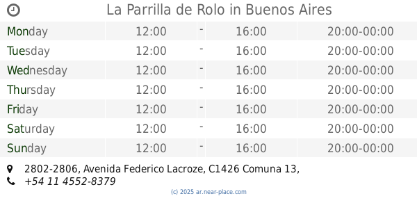
La Parrilla de Rolo
C1426CQO, Avenida Federico Lacroze 2802-2806
Restaurant
read more
979 m
Barrio Chino
Restaurant
read more
1.029 km
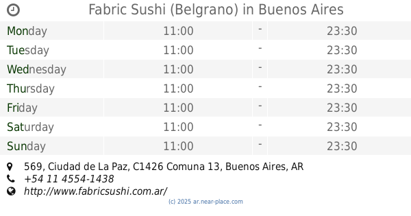
Fabric Sushi (Belgrano)
Ciudad de La Paz 569
Restaurant
read more
1.035 km
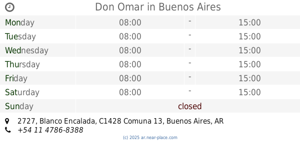
Don Omar
Blanco Encalada 2727
Restaurant
read more
1.065 km
Pizzeria Foggia Envios A Domicilio
Superí 1402
Restaurant
read more
📑
all categories
Accounting
Administrative area level 1
Administrative area level 2
Airport
Amusement park
Aquarium
Art gallery
Atm
Bakery
Bank
Bar
Beauty salon
Bicycle store
Book store
Bowling alley
Bus station
Cafe
Campground
Car dealer
Car rental
Car repair
Car wash
Casino
Cemetery
Church
City hall
Clothing store
Colloquial area
Convenience store
Country
Courthouse
Dentist
Department store
Doctor
Electrician
Electronics store
Embassy
Establishment
Finance
Fire station
Florist
Food
Funeral home
Furniture store
Gas station
General contractor
Grocery or supermarket
Gym
Hair care
Hardware store
Health
Hindu Temple
Home goods store
Hospital
Insurance agency
Intersection
Jewelry store
Laundry
Lawyer
Library
Light rail station
Liquor store
Local government office
Locality
Locksmith
Lodging
Meal delivery
Meal takeaway
Mosque
Movie rental
Movie theater
Moving company
Museum
Natural feature
Neighborhood
Night club
Painter
Park
Parking
Pet store
Pharmacy
Physiotherapist
Place of worship
Plumber
Point of interest
Police
Political
Post office
Premise
Real estate agency
Restaurant
Roofing contractor
Route
Rv park, camping
School
Shoe store
Shopping mall
Spa
Stadium
Storage
Store
Subpremise
Subway station
Supermarket
Synagogue
Taxi stand
Train station
Transit station
Travel agency
University
Veterinary care
Zoo
sublocality level 1
sublocality level 3
↑