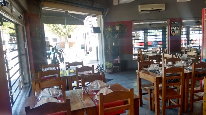
Restaurant nearby Lo de Pyter
Argentina
Restaurant nearby Lo de Pyter
Lo de Pyter
1753, Cosquín, C1440, Comuna 9, Buenos Aires, AR Argentina
contacts phone
:
+54
Latitude:
-34.6564571
, Longitude:
-58.5126795
larger map & directions
read more
nearest Restaurant
368 m
GLORIAS ARGENTINAS
Andalgalá 1982
Restaurant
read more
450 m
Bar J&B
Artigas 6601
Restaurant
read more
455 m
Tigre
Avenida Juan Bautista Alberdi 7237
Restaurant
read more
481 m
Pizzeria Lapataia
Molina 1802
Restaurant
read more
593 m
Lobato
Avenida Emilio Castro 6693
Restaurant
read more
594 m
Sabores Bettina
Argentina
Restaurant
read more
626 m
Rodríguez, Hugo; Felicitato, Pablo
Argentina
Restaurant
read more
654 m
Don Filetto
Carhué 1409
Restaurant
read more
654 m
Pastas Mouzo
Andalgalá 1323
Restaurant
read more
673 m
1
Saladillo 2050
Restaurant
read more
717 m
Rodó José E.
José Enrique Rodó 6849
Restaurant
read more
720 m
La Corvina
Avenida Emilio Castro 7296
Restaurant
read more
764 m
El Rey de la Entraña
José Enrique Rodó 7081
Restaurant
read more
887 m
Ramona
y, Av. Gral. Paz & Cnel. Dorrego, Lomas del Mirador
Restaurant
read more
895 m
Bien Argentino
Avenida Emilio Castro 6201
Restaurant
read more
897 m
Puesto de Comida Rodó y Cafayate
C1440AKF, José Enrique Rodó 6202-6300
Restaurant
read more
928 m
Casa Comidas
Ercilla 6249, Buenos Aires
Restaurant
read more
931 m
Pizza Libre Lomas Del Mirador
3217, B1752CFC, Vito D. Sabia 3199, Lomas del Mirador
Restaurant
read more
964 m
Parrilla Maria Brava
Avenida Emilio Castro 6139
Restaurant
read more
1.022 km
La Ochavita
Pieres 1399
Restaurant
read more
1.061 km
Pescaderia Marisqueria Mendismar
Avenida Juan Bautista Alberdi 5834
Restaurant
read more
1.111 km
PIZZA MAX
Brig. General Juan Manuel de Rosas 225, La Matanza
Restaurant
read more
1.144 km
Rafael N Bertoldo
Avenida Juan Bautista Alberdi 5775
Restaurant
read more
1.264 km
Rotiseria Señor Francisco
C1408GQQ, Timoteo Gordillo 815
Restaurant
read more
1.295 km
Cambalache
Avenida de los Corrales 6842
Restaurant
read more
📑
all categories
Accounting
Administrative area level 1
Administrative area level 2
Airport
Amusement park
Aquarium
Art gallery
Atm
Bakery
Bank
Bar
Beauty salon
Bicycle store
Book store
Bowling alley
Bus station
Cafe
Campground
Car dealer
Car rental
Car repair
Car wash
Casino
Cemetery
Church
City hall
Clothing store
Colloquial area
Convenience store
Country
Courthouse
Dentist
Department store
Doctor
Electrician
Electronics store
Embassy
Establishment
Finance
Fire station
Florist
Food
Funeral home
Furniture store
Gas station
General contractor
Grocery or supermarket
Gym
Hair care
Hardware store
Health
Hindu Temple
Home goods store
Hospital
Insurance agency
Intersection
Jewelry store
Laundry
Lawyer
Library
Light rail station
Liquor store
Local government office
Locality
Locksmith
Lodging
Meal delivery
Meal takeaway
Mosque
Movie rental
Movie theater
Moving company
Museum
Natural feature
Neighborhood
Night club
Painter
Park
Parking
Pet store
Pharmacy
Physiotherapist
Place of worship
Plumber
Point of interest
Police
Political
Post office
Premise
Real estate agency
Restaurant
Roofing contractor
Route
Rv park, camping
School
Shoe store
Shopping mall
Spa
Stadium
Storage
Store
Subpremise
Subway station
Supermarket
Synagogue
Taxi stand
Train station
Transit station
Travel agency
University
Veterinary care
Zoo
sublocality level 1
sublocality level 3
↑