Restaurant nearby Tiendas 2
Argentina
Restaurant nearby Tiendas 2
Tiendas 2
3001, República Arabe Siria, C1425, Comuna 14, Buenos Aires, AR Argentina
contacts phone
:
+54
Latitude:
-34.580453
, Longitude:
-58.4131449
larger map & directions
read more
nearest Restaurant
44 m
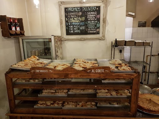
Pizzeria Guimpi V
República Arabe Siria 3012
Restaurant
read more
198 m
ANSIS CLUB
Avenida Cerviño 3293
Restaurant
read more
251 m
Malvón
Lafinur 3275
Restaurant
read more
384 m
Oscar Luis Cherro y Héctor Pablo Cherro Sociedad de Hecho
Cabello 3431
Restaurant
read more
623 m
Anastasia
Bulnes 2593
Restaurant
read more
682 m
PANINI
Bulnes 2776
Restaurant
read more
685 m
El Galeon del Norte • Restaurante Confitería
Avenida Santa Fe 4002
Restaurant
read more
693 m
Primo Pizza y Cerveza
Cabello 3119 Loc A
Restaurant
read more
721 m
Almacen De Pizzas BIBLOS
Beruti 3411
Restaurant
read more
792 m
La Leyenda
Güemes 4249
Restaurant
read more
805 m
Sixtina Ristorante
Avenida Raúl Scalabrini Ortíz 3624
Restaurant
read more
856 m
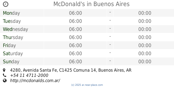
McDonald's
Avenida Santa Fe 4280
Restaurant
read more
892 m
Casa Vecchia
Alto Palermo Shopping Center, Avenida Santa Fe 3253
Restaurant
read more
926 m
PIZZA Taragui
Charcas 3673
Restaurant
read more
932 m
Tilo
C1425DTO, Billinghurst 2099
Restaurant
read more
975 m
Rincón Norteño
Avenida Raúl Scalabrini Ortíz 2140
Restaurant
read more
994 m
Velvet
Jerónimo Salguero 1807
Restaurant
read more
999 m
AVE CAESAR ALCORTA SHOPPING
Jerónimo Salguero 3172
Restaurant
read more
999 m
UrbanCreep
C1425, Jerónimo Salguero 3172
Restaurant
read more
1.041 km
Tonno Soho
Charcas 4400
Restaurant
read more
1.055 km
La Farola Small de Palermo
C1425BSF, Paraguay 4062
Restaurant
read more
1.113 km
La Cátedra Restaurante
Avenida Cerviño 4699
Restaurant
read more
1.129 km
Barbacoa Parrilla
ECA, Pasaje Bollini 2133
Restaurant
read more
1.139 km
1810 Cocina Regional
Julián Álvarez 1998
Restaurant
read more
1.2 km
Tijuana Mex & Bar
Guatemala 4540
Restaurant
read more
📑
all categories
Accounting
Administrative area level 1
Administrative area level 2
Airport
Amusement park
Aquarium
Art gallery
Atm
Bakery
Bank
Bar
Beauty salon
Bicycle store
Book store
Bowling alley
Bus station
Cafe
Campground
Car dealer
Car rental
Car repair
Car wash
Casino
Cemetery
Church
City hall
Clothing store
Colloquial area
Convenience store
Country
Courthouse
Dentist
Department store
Doctor
Electrician
Electronics store
Embassy
Establishment
Finance
Fire station
Florist
Food
Funeral home
Furniture store
Gas station
General contractor
Grocery or supermarket
Gym
Hair care
Hardware store
Health
Hindu Temple
Home goods store
Hospital
Insurance agency
Intersection
Jewelry store
Laundry
Lawyer
Library
Light rail station
Liquor store
Local government office
Locality
Locksmith
Lodging
Meal delivery
Meal takeaway
Mosque
Movie rental
Movie theater
Moving company
Museum
Natural feature
Neighborhood
Night club
Painter
Park
Parking
Pet store
Pharmacy
Physiotherapist
Place of worship
Plumber
Point of interest
Police
Political
Post office
Premise
Real estate agency
Restaurant
Roofing contractor
Route
Rv park, camping
School
Shoe store
Shopping mall
Spa
Stadium
Storage
Store
Subpremise
Subway station
Supermarket
Synagogue
Taxi stand
Train station
Transit station
Travel agency
University
Veterinary care
Zoo
sublocality level 1
sublocality level 3
↑