School nearby C.E.N.S 36
Argentina
School nearby C.E.N.S 36
C.E.N.S 36
758, Avenida Independencia, C1099, Comuna 1, Buenos Aires, AR Argentina
contacts phone
:
+54
Latitude:
-34.6175689
, Longitude:
-58.3767021
larger map & directions
read more
nearest School
13 m
Colegio Valentín Gómez
Avenida Independencia 758
School
read more
110 m
Escuela de Educación Especial Para Formación Laboral N° 37 Francisco Gatti
Avenida Independencia 672
School
read more
169 m
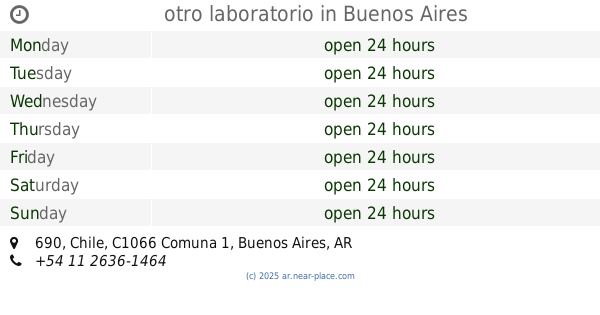
otro laboratorio
Chile 690
School
read more
243 m
Payamedico
Carlos Calvo 815
School
read more
279 m
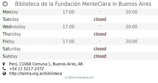
Biblioteca de la Fundación MenteClara
C1068AAC 669, AAC, Perú
School
read more
414 m
Cent Número 09
School
read more
464 m
ISSyS
Perú 1145
School
read more
479 m
Escuela Panamericana de PNL & Coaching
C1066AAK, Bolívar 547
School
read more
538 m
Escuela Infantil Pie Pequeño Sala Matern
México 1122
School
read more
573 m
independecia 1200
Avenida Independencia 1200
School
read more
609 m
Encuentro Nivel III
C1103ACH, Defensa 1102 390
School
read more
650 m
San Telmo Grupo Scout
Humberto 1º 301-399, C1103ACG
School
read more
654 m
Venezuela 847 Caba
Venezuela 356
School
read more
698 m
Asoc Ex Alumnos del Colegio Nac Bs As
Moreno 590
School
read more
733 m
Escuela
Avenida Paseo Colón 533
School
read more
746 m
Escuela De Psicología Social Tigre
Santiago del Estero 617
School
read more
756 m
Ministry of Interior
C1103ACE, Humberto 1º 243
School
read more
830 m
Sindicato de Empleados de Comercio Secretaria de Cultura y Capacitacion
C1069AAD, Chacabuco 170
School
read more
834 m
Severino Di Giovanni
Avenida Paseo Colón 1068
School
read more
865 m
Estudio De Cine
C1091AAW, Moreno 1195
School
read more
867 m
Incaa
C1074AAF, Salta 286-300
School
read more
984 m
Colegio Santa Catalina
Piedras
School
read more
995 m
IDIOMA BUENOS AIRES
C1086AAG, Avenida Hipólito Yrigoyen 571
School
read more
1.011 km
Instituto Argentino de Coctelería
Av. de Mayo 570
School
read more
1.012 km
Escuela De Guardavidas AMGAA CAPITAL
Presidente Luis Sáenz Peña 927, Buenos Aires
School
read more
📑
all categories
Accounting
Administrative area level 1
Administrative area level 2
Airport
Amusement park
Aquarium
Art gallery
Atm
Bakery
Bank
Bar
Beauty salon
Bicycle store
Book store
Bowling alley
Bus station
Cafe
Campground
Car dealer
Car rental
Car repair
Car wash
Casino
Cemetery
Church
City hall
Clothing store
Colloquial area
Convenience store
Country
Courthouse
Dentist
Department store
Doctor
Electrician
Electronics store
Embassy
Establishment
Finance
Fire station
Florist
Food
Funeral home
Furniture store
Gas station
General contractor
Grocery or supermarket
Gym
Hair care
Hardware store
Health
Hindu Temple
Home goods store
Hospital
Insurance agency
Intersection
Jewelry store
Laundry
Lawyer
Library
Light rail station
Liquor store
Local government office
Locality
Locksmith
Lodging
Meal delivery
Meal takeaway
Mosque
Movie rental
Movie theater
Moving company
Museum
Natural feature
Neighborhood
Night club
Painter
Park
Parking
Pet store
Pharmacy
Physiotherapist
Place of worship
Plumber
Point of interest
Police
Political
Post office
Premise
Real estate agency
Restaurant
Roofing contractor
Route
Rv park, camping
School
Shoe store
Shopping mall
Spa
Stadium
Storage
Store
Subpremise
Subway station
Supermarket
Synagogue
Taxi stand
Train station
Transit station
Travel agency
University
Veterinary care
Zoo
sublocality level 1
sublocality level 3
↑