School nearby Clases de Guitarra - Gabriel
Argentina
School nearby Clases de Guitarra - Gabriel
Clases de Guitarra - Gabriel
C1158ACB, Necochea 400 Argentina
contacts phone
:
+54
Latitude:
-34.6284796
, Longitude:
-58.363921
read more
nearest School
167 m
Escuela Carlos Della Penna
Doctor Eduardo Braun Menéndez 260
School
read more
199 m
SUPERVISIÓN DE 4
C1155AFB, Manuel Gálvez 156
School
read more
362 m
Jardin De Infante Escuela 11 D.E 4
Coronel Tomás Espora
School
read more
389 m
ANSV
Avenida Brasil 55
School
read more
474 m
Escuela 2 DE 4 Carlos R. Vignale
C1160AEI, Wenceslao Villafañe 453
School
read more
570 m
ALMIRANTE BROWN
C1161AEC, Aristóbulo del Valle 471
School
read more
627 m
Facultad ciencias economicas, UBA
Avenida Córdoba 2122
School
read more
704 m
CENTRO EDUCATIVO ISAURO ARANCIBIA
Avenida Paseo Colón 1318
School
read more
709 m
Universidad Popular de la Boca
Pinzón 546, LA BOCA
School
read more
842 m
intendencia naval
Benjamin Juan Lavaisse 1461
School
read more
900 m
Poli Federal
Bolívar 1500-1412, C1141AAF
School
read more
929 m
Kindergarten Din Di Lat
Piedras 1734
School
read more
995 m
Severino Di Giovanni
Avenida Paseo Colón 1068
School
read more
1000 m
ISFA
ISFA Manuel Belgrano, Avenida Regimiento de Patricios
School
read more
1.001 km
Cens Número 39
School
read more
1.008 km
Ministry of Interior
C1103ACE, Humberto 1º 243
School
read more
1.015 km
ACADEMIA DUQUE DE CAXIAS DE LA RA
Olavarría 594
School
read more
1.031 km
ESCUELA NORMAL N3
C1141AAB, Bolívar 1272
School
read more
1.045 km
Caebt 76 - Parroquia San Pedro González Telmo
School
read more
1.058 km
JARDIN JUGANDO A CRECER
289, Gaspar Melchor de Jovellanos
School
read more
1.063 km
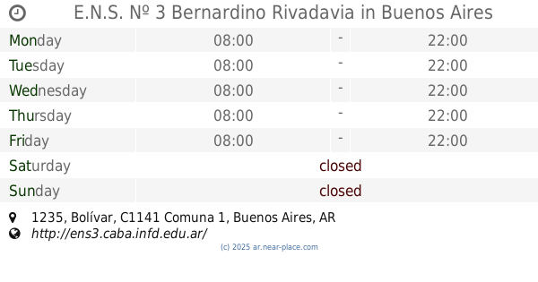
E.N.S. Nº 3 Bernardino Rivadavia
Bolívar 1235, Buenos Aires
School
read more
1.067 km
San Telmo Grupo Scout
Humberto 1º 301-399, C1103ACG
School
read more
1.091 km
Encuentro Nivel III
C1103ACH, Defensa 1102 390
School
read more
1.176 km
Instituto Parroquial Santa Lucia
Argentina
School
read more
1.244 km
ISSyS
Perú 1145
School
read more
📑
all categories
Accounting
Administrative area level 1
Administrative area level 2
Airport
Amusement park
Aquarium
Art gallery
Atm
Bakery
Bank
Bar
Beauty salon
Bicycle store
Book store
Bowling alley
Bus station
Cafe
Campground
Car dealer
Car rental
Car repair
Car wash
Casino
Cemetery
Church
City hall
Clothing store
Colloquial area
Convenience store
Country
Courthouse
Dentist
Department store
Doctor
Electrician
Electronics store
Embassy
Establishment
Finance
Fire station
Florist
Food
Funeral home
Furniture store
Gas station
General contractor
Grocery or supermarket
Gym
Hair care
Hardware store
Health
Hindu Temple
Home goods store
Hospital
Insurance agency
Intersection
Jewelry store
Laundry
Lawyer
Library
Light rail station
Liquor store
Local government office
Locality
Locksmith
Lodging
Meal delivery
Meal takeaway
Mosque
Movie rental
Movie theater
Moving company
Museum
Natural feature
Neighborhood
Night club
Painter
Park
Parking
Pet store
Pharmacy
Physiotherapist
Place of worship
Plumber
Point of interest
Police
Political
Post office
Premise
Real estate agency
Restaurant
Roofing contractor
Route
Rv park, camping
School
Shoe store
Shopping mall
Spa
Stadium
Storage
Store
Subpremise
Subway station
Supermarket
Synagogue
Taxi stand
Train station
Transit station
Travel agency
University
Veterinary care
Zoo
sublocality level 1
sublocality level 3
↑