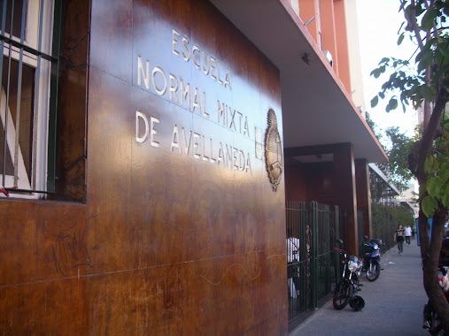
School nearby cmd lab
Argentina
School nearby cmd lab
cmd lab
Buenos Aires, C1277 CABA, Argentina
contacts phone
:
+54
Latitude:
-34.6551403
, Longitude:
-58.3802448
larger map & directions
read more
nearest School
36 m
Cafydma
C1293ABA, Algarrobo 1041
School
read more
37 m
estudio
C1293ABA, Algarrobo 1041
School
read more
423 m
Colegio Buen Consejo (Sede varones)
C1277ADM, Río Cuarto 2560
School
read more
478 m
Alu
C1275AGT, Vieytes 1710
School
read more
498 m
Pulgarcito Jardín Maternal
Argentina
School
read more
626 m
Escuela Nº 26 DE 5
San Antonio 682
School
read more
736 m
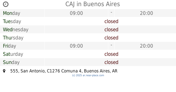
CAJ
San Antonio 555
School
read more
746 m
centro de apoyo escolar
California 2325
School
read more
778 m
Apoyo Escolar
Santa Elena 465
School
read more
816 m
Escuela Tecnica libertad
School
read more
879 m
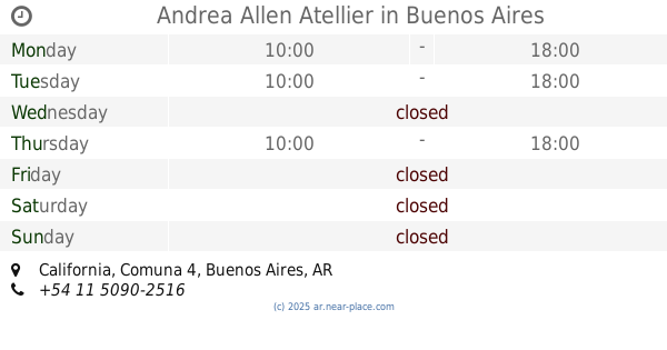
Andrea Allen Atellier
California, Buenos Aires
School
read more
891 m
E.E.S. N° 6 Granaderos de San Martín
B1868DUF, Giribone 648, Piñeiro
School
read more
913 m
Iglesia
Avenida General Iriarte C1291ACO
School
read more
916 m
Grupo Andando
Avenida General Iriarte 2901-2999, C1291ACO
School
read more
929 m
Escuela 11 DE 5
Lafayette 1879
School
read more
930 m
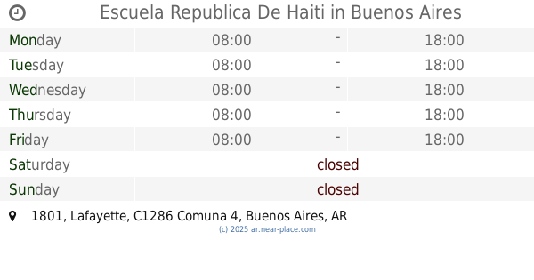
Escuela Republica De Haiti
1899, C1286AEG, Lafayette 1801
School
read more
937 m
Instituto Mariano Acosta
Monseñor M. de Andrea 255, Avellaneda
School
read more
1.004 km
Esc. Primaria Común Nº 13 Fray Mamerto Esquiú
Salom 332
School
read more
1.005 km
COLEGIO SANTA TERESA
Avenida Montes de Oca 1822
School
read more
1.082 km
Centro Integral De Patin Artistico
B1870AUF, Colón 328, Avellaneda
School
read more
1.09 km
AUTOESCUELA RO-CA
Avenida Bartolomé Mitre 351, Avellaneda
School
read more
1.123 km
Jardin De Infantes N° 932 Almafuerte
B1870BRD, Mariano Acosta 146, Avellaneda
School
read more
1.159 km
Colegio ENSPA
Avenida Manuel Belgrano 355, Avellaneda
School
read more
1.204 km
Jardin de Infantes Municipal Numero 19, Emilio Grande
Colón 446, Avellaneda
School
read more
1.212 km
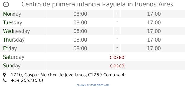
Centro de primera infancia Rayuela
Gaspar Melchor de Jovellanos 1710
School
read more
📑
all categories
Accounting
Administrative area level 1
Administrative area level 2
Airport
Amusement park
Aquarium
Art gallery
Atm
Bakery
Bank
Bar
Beauty salon
Bicycle store
Book store
Bowling alley
Bus station
Cafe
Campground
Car dealer
Car rental
Car repair
Car wash
Casino
Cemetery
Church
City hall
Clothing store
Colloquial area
Convenience store
Country
Courthouse
Dentist
Department store
Doctor
Electrician
Electronics store
Embassy
Establishment
Finance
Fire station
Florist
Food
Funeral home
Furniture store
Gas station
General contractor
Grocery or supermarket
Gym
Hair care
Hardware store
Health
Hindu Temple
Home goods store
Hospital
Insurance agency
Intersection
Jewelry store
Laundry
Lawyer
Library
Light rail station
Liquor store
Local government office
Locality
Locksmith
Lodging
Meal delivery
Meal takeaway
Mosque
Movie rental
Movie theater
Moving company
Museum
Natural feature
Neighborhood
Night club
Painter
Park
Parking
Pet store
Pharmacy
Physiotherapist
Place of worship
Plumber
Point of interest
Police
Political
Post office
Premise
Real estate agency
Restaurant
Roofing contractor
Route
Rv park, camping
School
Shoe store
Shopping mall
Spa
Stadium
Storage
Store
Subpremise
Subway station
Supermarket
Synagogue
Taxi stand
Train station
Transit station
Travel agency
University
Veterinary care
Zoo
sublocality level 1
sublocality level 3
↑