School nearby Instituto Saberes
Argentina
School nearby Instituto Saberes
Instituto Saberes
Ricardo Rojas 6739, Córdoba Argentina
contacts phone
:
+54
Latitude:
-31.3418827
, Longitude:
-64.2545714
read more
nearest School
34 m
Biografia Humana
Ricardo Rojas 6759, Córdoba
School
read more
136 m
La Salle
Córdoba
School
read more
625 m
Jardin hormiga Titina
Teodoro Richards, Andrés María Ampere y, Córdoba
School
read more
629 m
Colegio La Salle
Avenida Recta Martinoli 6602, Córdoba
School
read more
630 m
claudia
Raymond Poincare 7124, Córdoba
School
read more
644 m
Escuela Javier Lazcano Colodrero
Pozo de la Loma 7309, Córdoba
School
read more
696 m
Nicolodo
Santiago Ramón y Cajal, Argüello, Córdoba
School
read more
716 m
La Salle
Martinolli 6..666
School
read more
754 m
Escuela Dr. Alejandro Gallardo
Agustín Alcain 6032, Granja de Funes, Córdoba
School
read more
760 m
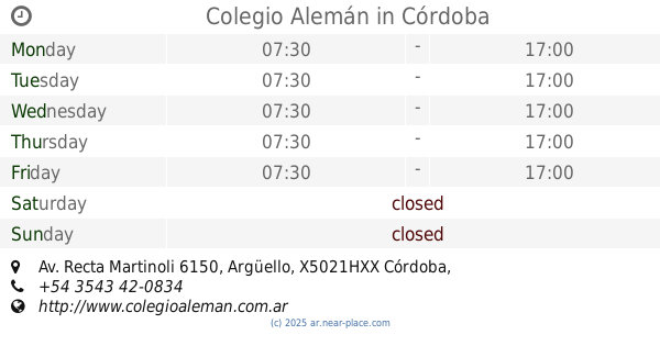
Colegio Alemán
Av. Recta Martinoli 6150, Argüello, Córdoba
School
read more
767 m
Telebingo
6782, ERB, Avenida Recta Martinolli, Córdoba
School
read more
768 m
wunjo
Rodolfo Martínez 3461, Córdoba
School
read more
788 m
Diego Heredia Academia de Baile
Martinolli 6838 Local 1, Argüello, Córdoba
School
read more
820 m
Escuela Javier Lazcano Colodredo
Calle Raimundo Caparros, Córdoba
School
read more
833 m
Casa Solidaria La Mamita
Donato Alvarez 7367, Argüello Norte, Córdoba
School
read more
833 m
Giavenno
Avenida Recta Martinolli 6877, Córdoba
School
read more
911 m
Neno
Carlos Andrés 4771, Córdoba
School
read more
964 m
Escuela huego leoneli
Córdoba
School
read more
970 m
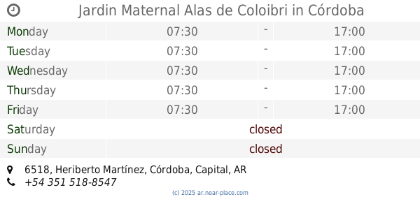
Jardin Maternal Alas de Coloibri
Heriberto Martínez 6518, Córdoba
School
read more
988 m
IPET 404
Córdoba
School
read more
994 m
IPEM 23
Alberto Fage 7071, Córdoba
School
read more
1.044 km
Escuela Mannequins
Av Recta Martinoli 5860, Villa Belgrano, Córdoba
School
read more
1.07 km
Taller Pentagrama
Niceforo Castellano 5775, Córdoba
School
read more
1.084 km
OKey Centro de Apoyo
Córdoba
School
read more
1.172 km
Pequeños Gigantes
Av. Rafael Nuñez 5738, Granja De Funes, Córdoba
School
read more
📑
all categories
Accounting
Administrative area level 1
Administrative area level 2
Airport
Amusement park
Aquarium
Art gallery
Atm
Bakery
Bank
Bar
Beauty salon
Bicycle store
Book store
Bowling alley
Bus station
Cafe
Campground
Car dealer
Car rental
Car repair
Car wash
Casino
Cemetery
Church
City hall
Clothing store
Colloquial area
Convenience store
Country
Courthouse
Dentist
Department store
Doctor
Electrician
Electronics store
Embassy
Establishment
Finance
Fire station
Florist
Food
Funeral home
Furniture store
Gas station
General contractor
Grocery or supermarket
Gym
Hair care
Hardware store
Health
Hindu Temple
Home goods store
Hospital
Insurance agency
Intersection
Jewelry store
Laundry
Lawyer
Library
Light rail station
Liquor store
Local government office
Locality
Locksmith
Lodging
Meal delivery
Meal takeaway
Mosque
Movie rental
Movie theater
Moving company
Museum
Natural feature
Neighborhood
Night club
Painter
Park
Parking
Pet store
Pharmacy
Physiotherapist
Place of worship
Plumber
Point of interest
Police
Political
Post office
Premise
Real estate agency
Restaurant
Roofing contractor
Route
Rv park, camping
School
Shoe store
Shopping mall
Spa
Stadium
Storage
Store
Subpremise
Subway station
Supermarket
Synagogue
Taxi stand
Train station
Transit station
Travel agency
University
Veterinary care
Zoo
sublocality level 1
sublocality level 3
↑