School nearby Jardin Paloma
Argentina
School nearby Jardin Paloma
Jardin Paloma
1152, Uriarte, C1414, Comuna 15, Buenos Aires, AR Argentina
contacts phone
:
+54
Latitude:
-34.5905371
, Longitude:
-58.4368119
larger map & directions
read more
nearest School
196 m
El Jugador Teatro
Castillo 1170
School
read more
302 m
GurruStyle
Gurruchaga 1040
School
read more
315 m
St. Gregory's School
Serrano 1320
School
read more
543 m
Clases De Piano
Aguirre 751, C1414ASO
School
read more
568 m
Escuela Bereshit
Gurruchaga 742
School
read more
600 m
Mindfulnes
José Antonio Cabrera 5637, C1414BHE
School
read more
613 m
Estimulacion Temprana
Bonpland 1314
School
read more
614 m
La Nave
Juan Ramirez de Velazco 512
School
read more
675 m
Pinipon
Honduras 5517
School
read more
698 m
Guionarte
Jorge Newbery 3827, C1414ATD
School
read more
720 m
Clases de Guitarra
AOO, Vera 781
School
read more
758 m
Colegio Nacional Nicolás Avellaneda
El Salvador 5528
School
read more
768 m
Common Primary School No. 9 John Chrysostom Lafinur
Gorriti 5740
School
read more
817 m
THE GARDEN OF ARTISTS
Avenida Corrientes 5843
School
read more
826 m
Acro
Malabia 538
School
read more
848 m
Demetra Alí Escuela de Cocina Natural
Ángel Justiniano Carranza 1645, C1414COQ
School
read more
863 m
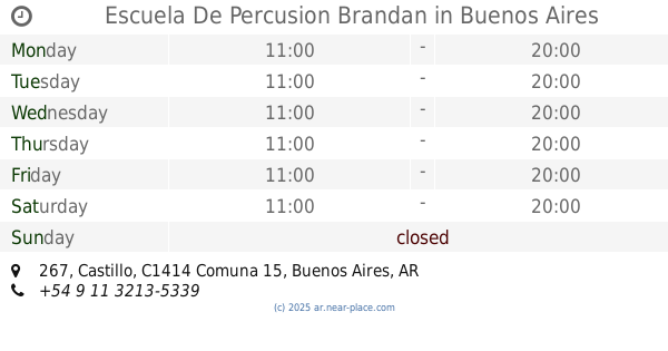
Escuela De Percusion Brandan
Castillo 267
School
read more
877 m
calitaiji
C1414DBD, Fray Justo Santa María de Oro 1872
School
read more
919 m
Grupo Scout San Francisco Javier
Jorge Luis Borges 1855, C1414DGE
School
read more
929 m
INSTITUTE Resurrection of the Lord
Avenida Dorrego 894
School
read more
997 m
EMAD Sede Jufré
C1414AYC, Jufré 141
School
read more
1.042 km
El Perchero Atelier Creativo
Malabia 376
School
read more
1.061 km
Scholem Aleijem
Gurruchaga 358
School
read more
1.23 km
Escuela N 24
Cañuelas 202
School
read more
1.29 km
CENTENARIO CON LA EDUCACIÓN PUBLICA
Pringles 1165
School
read more
📑
all categories
Accounting
Administrative area level 1
Administrative area level 2
Airport
Amusement park
Aquarium
Art gallery
Atm
Bakery
Bank
Bar
Beauty salon
Bicycle store
Book store
Bowling alley
Bus station
Cafe
Campground
Car dealer
Car rental
Car repair
Car wash
Casino
Cemetery
Church
City hall
Clothing store
Colloquial area
Convenience store
Country
Courthouse
Dentist
Department store
Doctor
Electrician
Electronics store
Embassy
Establishment
Finance
Fire station
Florist
Food
Funeral home
Furniture store
Gas station
General contractor
Grocery or supermarket
Gym
Hair care
Hardware store
Health
Hindu Temple
Home goods store
Hospital
Insurance agency
Intersection
Jewelry store
Laundry
Lawyer
Library
Light rail station
Liquor store
Local government office
Locality
Locksmith
Lodging
Meal delivery
Meal takeaway
Mosque
Movie rental
Movie theater
Moving company
Museum
Natural feature
Neighborhood
Night club
Painter
Park
Parking
Pet store
Pharmacy
Physiotherapist
Place of worship
Plumber
Point of interest
Police
Political
Post office
Premise
Real estate agency
Restaurant
Roofing contractor
Route
Rv park, camping
School
Shoe store
Shopping mall
Spa
Stadium
Storage
Store
Subpremise
Subway station
Supermarket
Synagogue
Taxi stand
Train station
Transit station
Travel agency
University
Veterinary care
Zoo
sublocality level 1
sublocality level 3
↑