School nearby Over Laboratorios
Argentina
School nearby Over Laboratorios
Over Laboratorios
2995, Avenida de los Constituyentes, Comuna 15, Buenos Aires, AR Argentina
contacts phone
:
+54
Latitude:
-34.5919831
, Longitude:
-58.4757121
larger map & directions
read more
nearest School
249 m
St. Therese of the Child Jesus
Quirós 2915
School
read more
266 m
Colegio Garcia Lorca
377, C1427CXA, Avenida Chorroarín 361
School
read more
349 m
Cátedra de Sociología
School
read more
474 m
Laboratorio di cucina - Donato De Santis
C1427DEN, Llerena 3030
School
read more
510 m
Notaries Association of the City of Buenos Aires
Avenida Chorroarín 751
School
read more
566 m
El Renacer de la Laguna - FVET - UBA
School
read more
576 m
Tambo Ovino, UBA Veterinaria
Acceso A Chorroarín
School
read more
595 m
Automotores
Avenida Chorroarín 200, C1427CWO
School
read more
595 m
Omar
Altolaguirre 1264
School
read more
683 m
Escuela Agrotecnica
School
read more
693 m
Escuela Técnico Profesional en Producción Agropecuaria y Agroalimentaria Fcv-Uba
School
read more
706 m
Colegio Mane
Doctor Joaquín Zabala
School
read more
710 m
Estacionamiento Escuela Agronomia
Avenida de las Casuarinas, Buenos Aires
School
read more
725 m
Bosque de Talar
Avenida Chorroarín 280
School
read more
766 m
Escuela 20
Campo, Buenos Aires
School
read more
787 m
Ciclo básico común Paternales
C1417DSE, Avenida San Martín 4453
School
read more
815 m
Arquería Altai
Raulies 2043
School
read more
830 m
Escuela Infantil Caballito de Mar
Tronador 412
School
read more
835 m
FAUBA
Avenida de los Constituyentes 3489
School
read more
856 m
Facultad de Agronomia
C1417DOG, Zamudio 3101-3199
School
read more
935 m
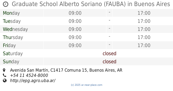
Graduate School Alberto Soriano (FAUBA)
4453, DSE, Avenida San Martín
School
read more
952 m
CENS 21
210, Balboa
School
read more
952 m
Cens 61
Balboa 210
School
read more
987 m
Instituto Adventista Florida
Avenida San Martín 4601, Florida Oeste
School
read more
1.124 km
Escuela Numero 27
Andonaegui 1632
School
read more
📑
all categories
Accounting
Administrative area level 1
Administrative area level 2
Airport
Amusement park
Aquarium
Art gallery
Atm
Bakery
Bank
Bar
Beauty salon
Bicycle store
Book store
Bowling alley
Bus station
Cafe
Campground
Car dealer
Car rental
Car repair
Car wash
Casino
Cemetery
Church
City hall
Clothing store
Colloquial area
Convenience store
Country
Courthouse
Dentist
Department store
Doctor
Electrician
Electronics store
Embassy
Establishment
Finance
Fire station
Florist
Food
Funeral home
Furniture store
Gas station
General contractor
Grocery or supermarket
Gym
Hair care
Hardware store
Health
Hindu Temple
Home goods store
Hospital
Insurance agency
Intersection
Jewelry store
Laundry
Lawyer
Library
Light rail station
Liquor store
Local government office
Locality
Locksmith
Lodging
Meal delivery
Meal takeaway
Mosque
Movie rental
Movie theater
Moving company
Museum
Natural feature
Neighborhood
Night club
Painter
Park
Parking
Pet store
Pharmacy
Physiotherapist
Place of worship
Plumber
Point of interest
Police
Political
Post office
Premise
Real estate agency
Restaurant
Roofing contractor
Route
Rv park, camping
School
Shoe store
Shopping mall
Spa
Stadium
Storage
Store
Subpremise
Subway station
Supermarket
Synagogue
Taxi stand
Train station
Transit station
Travel agency
University
Veterinary care
Zoo
sublocality level 1
sublocality level 3
↑