School nearby SEVIANORO
Argentina
School nearby SEVIANORO
SEVIANORO
Autopista Acceso Oeste, Ciudadela, Tres de Febrero, AR Argentinien
contacts phone
:
+54
Latitude:
-34.6346912
, Longitude:
-58.5334128
larger map & directions
read more
nearest School
134 m
servicio penitenciario federal
B1702AHG, San Cayetano 3327, Ciudadela
School
read more
679 m
G&O
Coronel Ramón Lorenzo Falcón 3281, Ciudadela
School
read more
681 m
MODEL SCHOOL PROJECT XXI
B1702AGR, Saavedra 3848, Ciudadela
School
read more
693 m
Jardín Modelo Proyecto XXI
Saavedra 3854, Ciudadela
School
read more
743 m
SCHOOL GUILLERMO ENRIQUE HUDSON
6840, AWF, Arregui
School
read more
796 m
Escuela Nº 32 San Francisco Solano
Ciudadela
School
read more
803 m
Nubecita
Ciudadela
School
read more
809 m
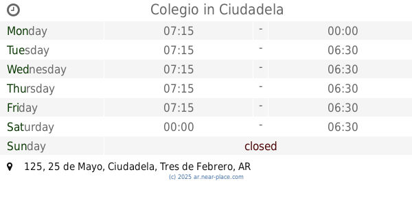
Colegio
25 de Mayo 125, Ciudadela
School
read more
838 m
Escuela 24 Maipú
Gallardo 521
School
read more
843 m
Escuela Primaria Común Número 24 Maipú
School
read more
857 m
Secundario Acelerado BCE
Avenida Rivadavia 11444
School
read more
878 m
Jardin de Infantes 909
Barragán & Croacia, Ciudadela
School
read more
902 m
Escuela Carlos Morel
C1408DXS, Ibarrola 7257
School
read more
906 m
Escuela 17 Carlos Morel
C1408DXS, Ibarrola 7239
School
read more
907 m
Academia Gastronómica Argentina A.G.A.
Carhué 28
School
read more
920 m
Instituto de Enseñanza Sadhana
Carhué 31
School
read more
940 m
Colegio Nº 13 Coronel de Marina Tomás Espora
Gallardo 149
School
read more
946 m
Escuela República Francesa
Montiel 153
School
read more
957 m
CIE CIUDADELA
B1702ACO, Santa Juana de Arco 4001-4057, Ciudadela
School
read more
968 m
CIIEdadela
4057, B1702ACO, Santa Juana de Arco 4001, Ciudadela
School
read more
1.009 km
Jardin de Infantes Municipal Larronda
Sócrates 966, Ciudadela
School
read more
1.031 km
Escuela Infantil Rulos y Moños
Ibarrola 7065
School
read more
1.065 km
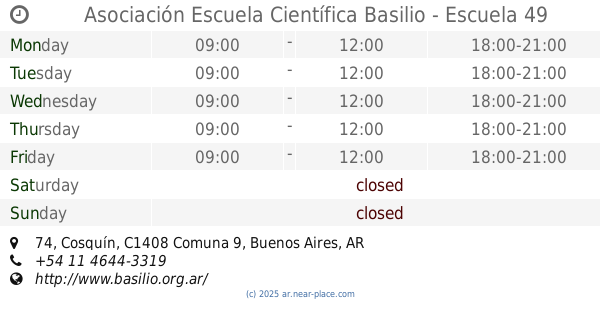
Asociación Escuela Científica Basilio - Escuela 49
Cosquín 74
School
read more
1.106 km
Cens Número 05
School
read more
1.19 km
Escuela Primaria Estados Unidos
Bruselas 785
School
read more
📑
all categories
Accounting
Administrative area level 1
Administrative area level 2
Airport
Amusement park
Aquarium
Art gallery
Atm
Bakery
Bank
Bar
Beauty salon
Bicycle store
Book store
Bowling alley
Bus station
Cafe
Campground
Car dealer
Car rental
Car repair
Car wash
Casino
Cemetery
Church
City hall
Clothing store
Colloquial area
Convenience store
Country
Courthouse
Dentist
Department store
Doctor
Electrician
Electronics store
Embassy
Establishment
Finance
Fire station
Florist
Food
Funeral home
Furniture store
Gas station
General contractor
Grocery or supermarket
Gym
Hair care
Hardware store
Health
Hindu Temple
Home goods store
Hospital
Insurance agency
Intersection
Jewelry store
Laundry
Lawyer
Library
Light rail station
Liquor store
Local government office
Locality
Locksmith
Lodging
Meal delivery
Meal takeaway
Mosque
Movie rental
Movie theater
Moving company
Museum
Natural feature
Neighborhood
Night club
Painter
Park
Parking
Pet store
Pharmacy
Physiotherapist
Place of worship
Plumber
Point of interest
Police
Political
Post office
Premise
Real estate agency
Restaurant
Roofing contractor
Route
Rv park, camping
School
Shoe store
Shopping mall
Spa
Stadium
Storage
Store
Subpremise
Subway station
Supermarket
Synagogue
Taxi stand
Train station
Transit station
Travel agency
University
Veterinary care
Zoo
sublocality level 1
sublocality level 3
↑