Supermarket nearby DIA
Argentina
Supermarket nearby DIA
DIA
8378, Avenida Rivadavia, C1407, Comuna 10, Buenos Aires, AR Argentina
contacts phone
:
+54 11 4307-1221
website:
www.supermercadosdia.com.ar
Latitude:
-34.633947
, Longitude:
-58.481692
larger map & directions
read more
nearest Supermarket
38 m
Carrefour Express
Avenida Rivadavia 8421
Supermarket
read more
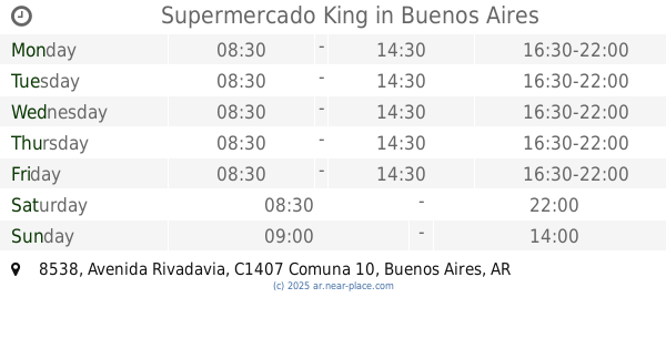
199 m
Supermercado King
Avenida Rivadavia 8538
Supermarket
read more
206 m
chino
Avenida Rivadavia 8538
Supermarket
read more
235 m
Supermercado elegido
Candelaria 126
Supermarket
read more
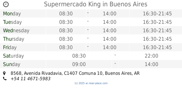
250 m
Supermercado King
Avenida Rivadavia 8568
Supermarket
read more
284 m
Pixiu
Bacacay 3952, C1407EDN C1407EDD
Supermarket
read more
434 m
Carrefour Express Segurola 279
Avenida Segurola 279
Supermarket
read more
444 m
Carrefour
Avenida Rivadavia 8690
Supermarket
read more
484 m
Xiulan Chen
Avenida Segurola 288
Supermarket
read more
582 m
La Vuelta
Avenida Olivera 21
Supermarket
read more
605 m
El Satisfecho
Bahía Blanca 447
Supermarket
read more
633 m
Supermercados Día
C1407DYN, Avenida Rivadavia 7850
Supermarket
read more
660 m
SUPERMERCADO FULL
Avenida Juan Bautista Alberdi 4165
Supermarket
read more
678 m
Supermercados Día
Avenida Segurola 456
Supermarket
read more
688 m
Día
Avenida Rivadavia 8875
Supermarket
read more
695 m
Día
Avenida Lacarra 574
Supermarket
read more
818 m
Carrefour Express
Avenida Directorio 3960
Supermarket
read more
821 m
Supermercado Argenchino
Avenida Directorio 3966
Supermarket
read more
853 m
FORTUNA
Coronel Ramón Lorenzo Falcón
Supermarket
read more
889 m
Carrefour Express
Carrasco 421
Supermarket
read more
993 m
LEE KYE SOO
Campana 567
Supermarket
read more
1.011 km
Supermercados DIA
Doctor Juan Felipe Aranguren 4501, C1407ELY
Supermarket
read more
1.028 km
Changomás
Avenida Rivadavia 9150
Supermarket
read more
1.05 km
Supermercado
Morón 3273, C1406FVS
Supermarket
read more
1.11 km
Supermercado Koreano
Morón 3175, C1406FVQ
Supermarket
read more
📑
all categories
Accounting
Administrative area level 1
Administrative area level 2
Airport
Amusement park
Aquarium
Art gallery
Atm
Bakery
Bank
Bar
Beauty salon
Bicycle store
Book store
Bowling alley
Bus station
Cafe
Campground
Car dealer
Car rental
Car repair
Car wash
Casino
Cemetery
Church
City hall
Clothing store
Colloquial area
Convenience store
Country
Courthouse
Dentist
Department store
Doctor
Electrician
Electronics store
Embassy
Establishment
Finance
Fire station
Florist
Food
Funeral home
Furniture store
Gas station
General contractor
Grocery or supermarket
Gym
Hair care
Hardware store
Health
Hindu Temple
Home goods store
Hospital
Insurance agency
Intersection
Jewelry store
Laundry
Lawyer
Library
Light rail station
Liquor store
Local government office
Locality
Locksmith
Lodging
Meal delivery
Meal takeaway
Mosque
Movie rental
Movie theater
Moving company
Museum
Natural feature
Neighborhood
Night club
Painter
Park
Parking
Pet store
Pharmacy
Physiotherapist
Place of worship
Plumber
Point of interest
Police
Political
Post office
Premise
Real estate agency
Restaurant
Roofing contractor
Route
Rv park, camping
School
Shoe store
Shopping mall
Spa
Stadium
Storage
Store
Subpremise
Subway station
Supermarket
Synagogue
Taxi stand
Train station
Transit station
Travel agency
University
Veterinary care
Zoo
sublocality level 1
sublocality level 3
↑