Supermarket nearby Dia Maxi
Argentina
Supermarket nearby Dia Maxi
Dia Maxi
2160, Avenida Independencia, C1225, Comuna 3, Buenos Aires, AR Argentina
contacts phone
:
+54
Latitude:
-34.618608
, Longitude:
-58.3968929
larger map & directions
read more
nearest Supermarket
124 m
KIBA
Avenida Independencia 2238
Supermarket
read more
143 m
Autoservicio Diana
Avenida Independencia 2429
Supermarket
read more
286 m
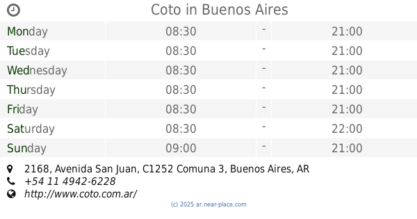
COTO
México 2236
Supermarket
read more
377 m
Supermercado Chino Mixle
Venezuela 2151
Supermarket
read more
459 m
Estrella China
Rincón 1182
Supermarket
read more
565 m
Coto
C1232AAQ, Avenida San Juan 2168
Supermarket
read more
627 m
Recepción Coto
2199, C1252AAG, Cochabamba 2101
Supermarket
read more
642 m
Carrefour
C1225AAW, Avenida Independencia 2728
Supermarket
read more
711 m
Disco
Avenida Entre Ríos 361
Supermarket
read more
729 m
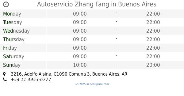
Autoservicio Zhang Fang
Adolfo Alsina 2216
Supermarket
read more
732 m
Dietética de Adriana
Chile
Supermarket
read more
815 m
Supermercado AQUÍ
Comb D L Pozos 1380, San Cristóbal
Supermarket
read more
830 m
Supermercado Humberto Primo 2802
Humberto 1º 2802
Supermarket
read more
831 m
Supermercado Alsina
Adolfo Alsina 1941
Supermarket
read more
905 m
supermecado
Presidente Luis Sáenz Peña 639
Supermarket
read more
906 m
Supermercado El Reencuentro
Presidente Luis Sáenz Peña 1071
Supermarket
read more
954 m
Carrefour Express
Avenida Belgrano 1560
Supermarket
read more
1.021 km
Huang Rong
Av. San Juan 1465, San Juan
Supermarket
read more
1.024 km
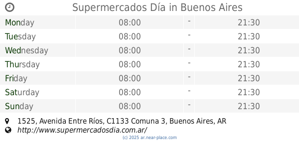
Supermercados Día
Avenida Entre Ríos 1525
Supermarket
read more
1.034 km
Carrefour Express
Avenida Hipólito Yrigoyen 1790
Supermarket
read more
1.043 km
Supermercado Endeno
Sarandí 2140
Supermarket
read more
1.098 km
MINI MERCADO
La Rioja 1101
Supermarket
read more
1.206 km
Carrefour Express
Moreno 1401
Supermarket
read more
1.209 km
Carrefour Express Moreno 1401
Moreno 1401
Supermarket
read more
1.244 km
Míni Mercado Autoservicio
C1110AAC, Presidente Luis Sáenz Peña 143
Supermarket
read more
📑
all categories
Accounting
Administrative area level 1
Administrative area level 2
Airport
Amusement park
Aquarium
Art gallery
Atm
Bakery
Bank
Bar
Beauty salon
Bicycle store
Book store
Bowling alley
Bus station
Cafe
Campground
Car dealer
Car rental
Car repair
Car wash
Casino
Cemetery
Church
City hall
Clothing store
Colloquial area
Convenience store
Country
Courthouse
Dentist
Department store
Doctor
Electrician
Electronics store
Embassy
Establishment
Finance
Fire station
Florist
Food
Funeral home
Furniture store
Gas station
General contractor
Grocery or supermarket
Gym
Hair care
Hardware store
Health
Hindu Temple
Home goods store
Hospital
Insurance agency
Intersection
Jewelry store
Laundry
Lawyer
Library
Light rail station
Liquor store
Local government office
Locality
Locksmith
Lodging
Meal delivery
Meal takeaway
Mosque
Movie rental
Movie theater
Moving company
Museum
Natural feature
Neighborhood
Night club
Painter
Park
Parking
Pet store
Pharmacy
Physiotherapist
Place of worship
Plumber
Point of interest
Police
Political
Post office
Premise
Real estate agency
Restaurant
Roofing contractor
Route
Rv park, camping
School
Shoe store
Shopping mall
Spa
Stadium
Storage
Store
Subpremise
Subway station
Supermarket
Synagogue
Taxi stand
Train station
Transit station
Travel agency
University
Veterinary care
Zoo
sublocality level 1
sublocality level 3
↑