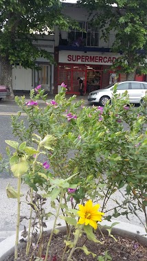
Supermarket nearby For You Supermercado
Argentina
Supermarket nearby For You Supermercado
For You Supermercado
5566, Avenida Emilio Castro, C1440, Comuna 9, Buenos Aires, AR Argentina
contacts phone
:
+54
Latitude:
-34.6457617
, Longitude:
-58.5018164
larger map & directions
read more
nearest Supermarket
543 m
Carrefour
Avenida Juan Bautista Alberdi 5719
Supermarket
read more
548 m
Supermercado Las Mil y Una Galletitas
Avenida Emilio Castro 6039
Supermarket
read more
580 m
Supermercado Chino
Miralla 1217-1219
Supermarket
read more
658 m
Diego
Fonrouge 641
Supermarket
read more
689 m
Market Luna
Avenida Larrazábal
Supermarket
read more
702 m
JELYCA
Avenida Juan Bautista Alberdi 4851
Supermarket
read more
767 m
Carrefour Express Alberdi 4808
Avenida Juan Bautista Alberdi 4808, Parque Avellaneda
Supermarket
read more
820 m
Diego
Miralla 275
Supermarket
read more
845 m
Supermercado Weng Chunying
Manzoni 71
Supermarket
read more
852 m
Supermercado Ema
Rafaela 4902
Supermarket
read more
866 m
Supermercado Mario
Avenida Rivadavia 10048
Supermarket
read more
870 m
Supermercado Liu
Avenida Rivadavia 10060
Supermarket
read more
878 m
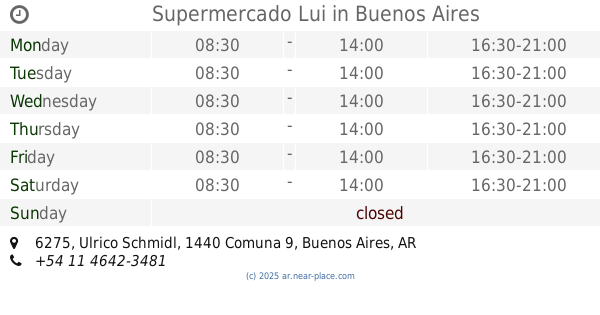
Supermercado Lui
Ulrico Schmidl 6275
Supermarket
read more
891 m
Guo Kong F.
Pieres 534
Supermarket
read more
915 m
DIA
Avenida Rivadavia 9650
Supermarket
read more
968 m
Carrefour Express
Martiniano Leguizamón 1580
Supermarket
read more
968 m
Carrefour Express Leguizamon 1576
Martiniano Leguizamòn 1576
Supermarket
read more
988 m
Supermercado Gaston
Avenida Rivadavia 10255
Supermarket
read more
988 m
Sup. Villa Luro
AAC, Avenida Rivadavia 10255
Supermarket
read more
1.057 km
Carrefour
Avenida Rivadavia 9436
Supermarket
read more
1.065 km
La Amistad
Avenida Rivadavia 10418
Supermarket
read more
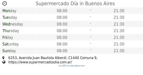
1.067 km
Supermercado Día
Avenida Juan Bautista Alberdi 6253
Supermarket
read more
1.119 km
Super Premier
Avenida Directorio 5142
Supermarket
read more
1.144 km
Supermercados DIA
Avenida Directorio 5024
Supermarket
read more
1.165 km
Día
Avenida Rivadavia 10536
Supermarket
read more
📑
all categories
Accounting
Administrative area level 1
Administrative area level 2
Airport
Amusement park
Aquarium
Art gallery
Atm
Bakery
Bank
Bar
Beauty salon
Bicycle store
Book store
Bowling alley
Bus station
Cafe
Campground
Car dealer
Car rental
Car repair
Car wash
Casino
Cemetery
Church
City hall
Clothing store
Colloquial area
Convenience store
Country
Courthouse
Dentist
Department store
Doctor
Electrician
Electronics store
Embassy
Establishment
Finance
Fire station
Florist
Food
Funeral home
Furniture store
Gas station
General contractor
Grocery or supermarket
Gym
Hair care
Hardware store
Health
Hindu Temple
Home goods store
Hospital
Insurance agency
Intersection
Jewelry store
Laundry
Lawyer
Library
Light rail station
Liquor store
Local government office
Locality
Locksmith
Lodging
Meal delivery
Meal takeaway
Mosque
Movie rental
Movie theater
Moving company
Museum
Natural feature
Neighborhood
Night club
Painter
Park
Parking
Pet store
Pharmacy
Physiotherapist
Place of worship
Plumber
Point of interest
Police
Political
Post office
Premise
Real estate agency
Restaurant
Roofing contractor
Route
Rv park, camping
School
Shoe store
Shopping mall
Spa
Stadium
Storage
Store
Subpremise
Subway station
Supermarket
Synagogue
Taxi stand
Train station
Transit station
Travel agency
University
Veterinary care
Zoo
sublocality level 1
sublocality level 3
↑