Supermarket nearby Supermercado Alan
Argentina
Supermarket nearby Supermercado Alan
Supermercado Alan
2181, Emilio Lamarca, Comuna 11, Buenos Aires, AR Argentina
contacts phone
:
+54
Latitude:
-34.6122174
, Longitude:
-58.494073
larger map & directions
read more
nearest Supermarket
218 m
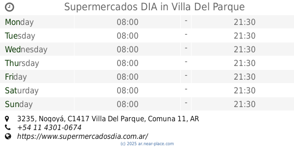
Supermercados DIA
Emilio Lamarca 1971
Supermarket
read more
226 m
Lo De Nico - Kiosco
C1417GZF, Lascano 3880
Supermarket
read more
294 m
Supermercado Monza
Avenida Álvarez Jonte 3468
Supermarket
read more
351 m
SUPERMARKET HF HUA FU
Avenida Álvarez Jonte 3418
Supermarket
read more
351 m
SUPERMERCADO HF HUA FU
Avenida Álvarez Jonte 3418
Supermarket
read more
462 m
Supermercados DIA
Avenida Álvarez Jonte 4058
Supermarket
read more
509 m
Supermercado Conquista
C1417FYT, Marcos Sastre 3552
Supermarket
read more
521 m
Super Tendy Mojito 12$
C1417ACG, Campana 2463
Supermarket
read more
530 m
super for you
C1417ASH, Bahía Blanca 2438
Supermarket
read more
623 m
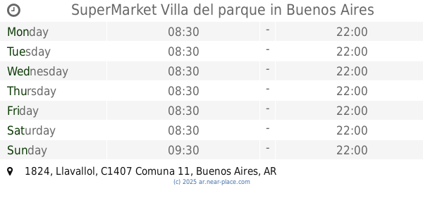
SuperMarket Villa del parque
C1407DWH, Llavallol 1824
Supermarket
read more
628 m
Supermercados DIA
Cuenca 2462
Supermarket
read more
724 m
Carrefour Express
Nogoyá 3644
Supermarket
read more
724 m
Carrefour Express
Nogoyá 3664
Supermarket
read more
763 m
SUPERMERCADO ARGENCHINO
Gualeguaychú 2171
Supermarket
read more
771 m
Supermercados DIA
Nogoyá 3529
Supermarket
read more
820 m
SUPERMERCADO MR. AHORRO
Emilio Lamarca 1525
Supermarket
read more
871 m
SUPERMERCADO La Fortuna
1730, Cuenca
Supermarket
read more
891 m
Supermercado Chino
C1407FMO, Camarones 4009
Supermarket
read more
910 m
Supermercados DIA
Nogoyá 3235, Villa Del Parque
Supermarket
read more
920 m
Coto
C1407GAV, Elpidio González 4400
Supermarket
read more
960 m
Supermercados Día
Avenida Álvarez Jonte 4471
Supermarket
read more
999 m
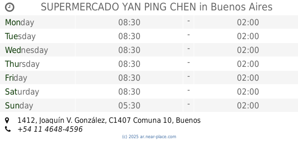
SUPERMERCADO YAN PING CHEN
Joaquín V. González 1412
Supermarket
read more
1000 m
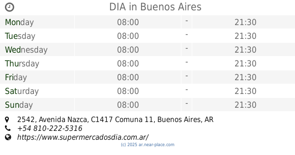
DIA
Avenida Nazca 2542
Supermarket
read more
1.009 km
SUPERMERCADO SEGUROLA
Avenida Segurola 2062
Supermarket
read more
1.047 km
Supermercado Nazca
Avenida Nazca 2335
Supermarket
read more
📑
all categories
Accounting
Administrative area level 1
Administrative area level 2
Airport
Amusement park
Aquarium
Art gallery
Atm
Bakery
Bank
Bar
Beauty salon
Bicycle store
Book store
Bowling alley
Bus station
Cafe
Campground
Car dealer
Car rental
Car repair
Car wash
Casino
Cemetery
Church
City hall
Clothing store
Colloquial area
Convenience store
Country
Courthouse
Dentist
Department store
Doctor
Electrician
Electronics store
Embassy
Establishment
Finance
Fire station
Florist
Food
Funeral home
Furniture store
Gas station
General contractor
Grocery or supermarket
Gym
Hair care
Hardware store
Health
Hindu Temple
Home goods store
Hospital
Insurance agency
Intersection
Jewelry store
Laundry
Lawyer
Library
Light rail station
Liquor store
Local government office
Locality
Locksmith
Lodging
Meal delivery
Meal takeaway
Mosque
Movie rental
Movie theater
Moving company
Museum
Natural feature
Neighborhood
Night club
Painter
Park
Parking
Pet store
Pharmacy
Physiotherapist
Place of worship
Plumber
Point of interest
Police
Political
Post office
Premise
Real estate agency
Restaurant
Roofing contractor
Route
Rv park, camping
School
Shoe store
Shopping mall
Spa
Stadium
Storage
Store
Subpremise
Subway station
Supermarket
Synagogue
Taxi stand
Train station
Transit station
Travel agency
University
Veterinary care
Zoo
sublocality level 1
sublocality level 3
↑