Supermarket nearby supermercado alianza
Argentina
Supermarket nearby supermercado alianza
supermercado alianza
Parque Patricios, C1260 CABA, Argentina
contacts phone
:
+54
Latitude:
-34.6346526
, Longitude:
-58.4097057
larger map & directions
read more
nearest Supermarket
358 m
Autoservicio Brasil (super Chino)
La Rioja 1884
Supermarket
read more
363 m
Autoservicio Brasil
Avenida Brasil 1999
Supermarket
read more
367 m
Supermercado Divino
Virrey Liniers 1826
Supermarket
read more
393 m
Carrefour Express
La Rioja 2040
Supermarket
read more
398 m
Supermercados DIA
La Rioja 1850
Supermarket
read more
525 m
Alianza
Avenida Juan de Garay 3200, Buenos Aires
Supermarket
read more
563 m
Supermercados DIA
Avenida Caseros 2938
Supermarket
read more
603 m
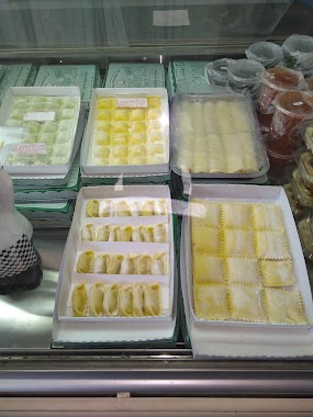
Fábrica de Pastas Amelia
Avenida Boedo 1639
Supermarket
read more
622 m
Supermercado Amor
Avenida Boedo 1564
Supermarket
read more
643 m
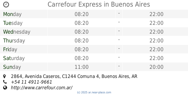
Carrefour Express Caseros 2864
Avenida Caseros 2864
Supermarket
read more
643 m
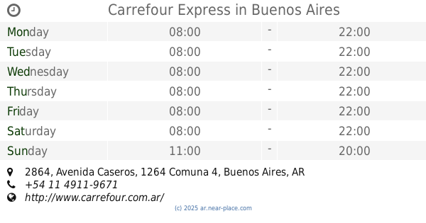
Carrefour Express
C1264AAV, Avenida Caseros 2864
Supermarket
read more
643 m
Carrefour Express
Avenida Caseros 2864
Supermarket
read more
646 m
HONG ZIKUN
Avenida Boedo 1550
Supermarket
read more
657 m
Carrefour Express
Avenida Caseros 3535
Supermarket
read more
661 m
Express Avenida Caseros 3535
Avenida Caseros 3535
Supermarket
read more
729 m
La gran aldea
Avenida Boedo 2075, Buenos Aires
Supermarket
read more
734 m
Super Mercado Chino
24 de Noviembre 1450
Supermarket
read more
770 m
Cl
Avenida Juan de Garay 3751
Supermarket
read more
832 m
Supermarket saenz
Avenida Sáenz 100
Supermarket
read more
913 m
Autoservicio Mechi
Avenida Caseros 2651
Supermarket
read more
935 m
SUPERMERCADO HUA LONG
Pavón 3883
Supermarket
read more
989 m
HUIMINsupermercado
C1437ETF, Iguazú
Supermarket
read more
1.057 km
Carrefour Express
Inclán 2502
Supermarket
read more
1.199 km
Geo Supermercado gastronomico express
Avenida Jujuy 1351
Supermarket
read more
1.343 km
Carrefour express
Avenida San Juan 3900
Supermarket
read more
📑
all categories
Accounting
Administrative area level 1
Administrative area level 2
Airport
Amusement park
Aquarium
Art gallery
Atm
Bakery
Bank
Bar
Beauty salon
Bicycle store
Book store
Bowling alley
Bus station
Cafe
Campground
Car dealer
Car rental
Car repair
Car wash
Casino
Cemetery
Church
City hall
Clothing store
Colloquial area
Convenience store
Country
Courthouse
Dentist
Department store
Doctor
Electrician
Electronics store
Embassy
Establishment
Finance
Fire station
Florist
Food
Funeral home
Furniture store
Gas station
General contractor
Grocery or supermarket
Gym
Hair care
Hardware store
Health
Hindu Temple
Home goods store
Hospital
Insurance agency
Intersection
Jewelry store
Laundry
Lawyer
Library
Light rail station
Liquor store
Local government office
Locality
Locksmith
Lodging
Meal delivery
Meal takeaway
Mosque
Movie rental
Movie theater
Moving company
Museum
Natural feature
Neighborhood
Night club
Painter
Park
Parking
Pet store
Pharmacy
Physiotherapist
Place of worship
Plumber
Point of interest
Police
Political
Post office
Premise
Real estate agency
Restaurant
Roofing contractor
Route
Rv park, camping
School
Shoe store
Shopping mall
Spa
Stadium
Storage
Store
Subpremise
Subway station
Supermarket
Synagogue
Taxi stand
Train station
Transit station
Travel agency
University
Veterinary care
Zoo
sublocality level 1
sublocality level 3
↑