Supermarket nearby Supermercados DIA
Argentina
Supermarket nearby Supermercados DIA
Supermercados DIA
3172, Avenida San Martín, Comuna 15, Buenos Aires, AR Argentina
contacts phone
:
+54
website:
www.supermercadosdia.com.ar
Latitude:
-34.5995118
, Longitude:
-58.4784773
larger map & directions
read more
nearest Supermarket
164 m
Supermercados DIA
Avenida San Martín 4156
Supermarket
read more
327 m
Carrefour
Raulies 1906
Supermarket
read more
459 m
Maxiconsumo
Bolivia 2785, Villa del Parque
Supermarket
read more
524 m
Autoservicio Chino
General José Gervasio Artigas 2546, 2502
Supermarket
read more
582 m
Carrefour
Avenida Warnes 2707
Supermarket
read more
601 m
Carrefour express
Avenida San Martín 4685
Supermarket
read more
618 m
Furiasse
Nogoyá 2501
Supermarket
read more
634 m
Dai Nippon S.a
C1416FGB, Punta Arenas 1612
Supermarket
read more
643 m
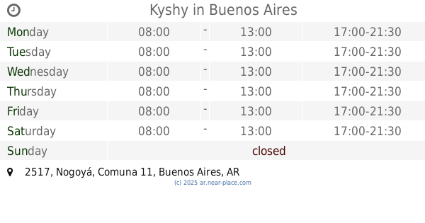
Kyshy
Nogoyá 2517
Supermarket
read more
706 m
Supermercado Hong Kong
C1417DAA, Pernambuco 2471-2499
Supermarket
read more
710 m
Supermercado Hong Kong
Lascano 2655
Supermarket
read more
743 m
JC
Avenida San Martín
Supermarket
read more
752 m
Supermercados Día
Avenida Álvarez Jonte 2201
Supermarket
read more
768 m
Supermercado Lina
Avenida Álvarez Jonte 2152
Supermarket
read more
814 m
Carrefour Express Álvarez Jonte 1938
Álvarez Jonte 1938, Buenos Aires
Supermarket
read more
844 m
Obrador
Juan Agustín García 2099, C1416EKU
Supermarket
read more
878 m
Chambi Aida/Yang Huazhong Supermercado
Avenida Álvarez Jonte 1845
Supermarket
read more
911 m
Sepelios
Avenida Álvarez Jonte 2548
Supermarket
read more
958 m
Supermercado Xin Yun
Avenida San Martín 3140
Supermarket
read more
995 m
Terrada B & B
Terrada 3131
Supermarket
read more
1.005 km
Supermercado La Naturaleza
San Blas 2374, C1416EFP
Supermarket
read more
1.016 km
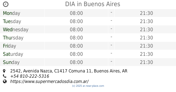
DIA
Avenida Nazca 2542
Supermarket
read more
1.023 km
ETERNO
Avenida Nazca 2882
Supermarket
read more
1.025 km
Carrefour Market
Avenida Nazca 2951
Supermarket
read more
1.093 km
Supermercado Nazca
Avenida Nazca 2335
Supermarket
read more
📑
all categories
Accounting
Administrative area level 1
Administrative area level 2
Airport
Amusement park
Aquarium
Art gallery
Atm
Bakery
Bank
Bar
Beauty salon
Bicycle store
Book store
Bowling alley
Bus station
Cafe
Campground
Car dealer
Car rental
Car repair
Car wash
Casino
Cemetery
Church
City hall
Clothing store
Colloquial area
Convenience store
Country
Courthouse
Dentist
Department store
Doctor
Electrician
Electronics store
Embassy
Establishment
Finance
Fire station
Florist
Food
Funeral home
Furniture store
Gas station
General contractor
Grocery or supermarket
Gym
Hair care
Hardware store
Health
Hindu Temple
Home goods store
Hospital
Insurance agency
Intersection
Jewelry store
Laundry
Lawyer
Library
Light rail station
Liquor store
Local government office
Locality
Locksmith
Lodging
Meal delivery
Meal takeaway
Mosque
Movie rental
Movie theater
Moving company
Museum
Natural feature
Neighborhood
Night club
Painter
Park
Parking
Pet store
Pharmacy
Physiotherapist
Place of worship
Plumber
Point of interest
Police
Political
Post office
Premise
Real estate agency
Restaurant
Roofing contractor
Route
Rv park, camping
School
Shoe store
Shopping mall
Spa
Stadium
Storage
Store
Subpremise
Subway station
Supermarket
Synagogue
Taxi stand
Train station
Transit station
Travel agency
University
Veterinary care
Zoo
sublocality level 1
sublocality level 3
↑