Supermarket nearby Supermercados Día
Argentina
Supermarket nearby Supermercados Día
Supermercados Día
838, Avenida Independencia, C1099, Comuna 1, Buenos Aires, AR Argentina
contacts phone
:
+54
website:
www.supermercadosdia.com.ar
Latitude:
-34.6176276
, Longitude:
-58.3779643
larger map & directions
read more
nearest Supermarket
103 m
Natura
Estados Unidos 850
Supermarket
read more
234 m
Minimarket Casanova
Carlos Calvo 811
Supermarket
read more
374 m
Supermercado
C1072AAV, Bernardo de Irigoyen 1074
Supermarket
read more
386 m
Autoservicio Los Tres Hermanos
Tacuarí 1118
Supermarket
read more
458 m
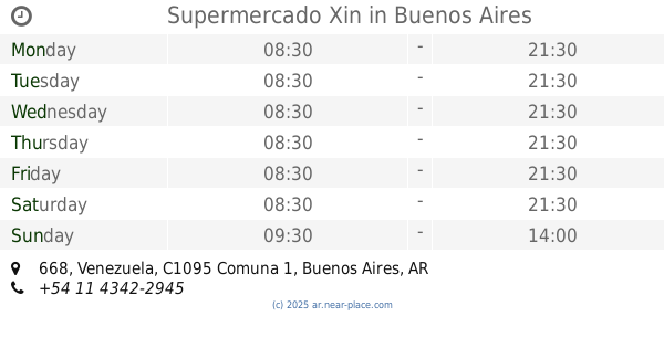
Supermercado Xin
Venezuela 668
Supermarket
read more
469 m
Super mercado Bosio
Salta 928
Supermarket
read more
510 m
Ko Li y
Chile 1228
Supermarket
read more
536 m
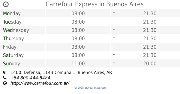
Carrefour Express Perú 487
Perú 487
Supermarket
read more
596 m
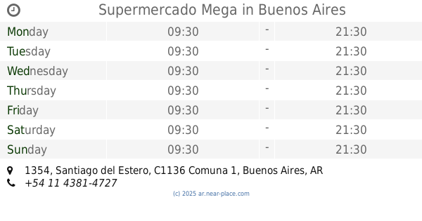
Supermercado Mega
Santiago del Estero 1354
Supermarket
read more
680 m
Supermercado Xin
Humberto 1º 1286
Supermarket
read more
680 m
Carrefur
C1064AFD, San Lorenzo 330-332
Supermarket
read more
747 m
Mu Xuhua
San José 990
Supermarket
read more
760 m
Chino De Reja Amarilla
Tacuarí 1377
Supermarket
read more
778 m
Autoservicio Cairoli Hnos Envios A Domicilio
Cochabamba 502
Supermarket
read more
867 m
Supermercado Panda
Defensa 326
Supermarket
read more
893 m
supermecado
Presidente Luis Sáenz Peña 639
Supermarket
read more
933 m
Carrefour Express
Tacuarí 89
Supermarket
read more
942 m
Supermercado El Reencuentro
Presidente Luis Sáenz Peña 1071
Supermarket
read more
952 m
Carrefour Express
Defensa 1400
Supermarket
read more
953 m
Huang Rong
Av. San Juan 1465, San Juan
Supermarket
read more
961 m
Carrefour Express
Avenida Paseo Colón 1179
Supermarket
read more
966 m
Carrefour Express
Moreno 1401
Supermarket
read more
967 m
Carrefour Express Moreno 1401
Moreno 1401
Supermarket
read more
1.044 km
Carrefour Express
Avenida Belgrano 1560
Supermarket
read more
1.182 km
Míni Mercado Autoservicio
C1110AAC, Presidente Luis Sáenz Peña 143
Supermarket
read more
📑
all categories
Accounting
Administrative area level 1
Administrative area level 2
Airport
Amusement park
Aquarium
Art gallery
Atm
Bakery
Bank
Bar
Beauty salon
Bicycle store
Book store
Bowling alley
Bus station
Cafe
Campground
Car dealer
Car rental
Car repair
Car wash
Casino
Cemetery
Church
City hall
Clothing store
Colloquial area
Convenience store
Country
Courthouse
Dentist
Department store
Doctor
Electrician
Electronics store
Embassy
Establishment
Finance
Fire station
Florist
Food
Funeral home
Furniture store
Gas station
General contractor
Grocery or supermarket
Gym
Hair care
Hardware store
Health
Hindu Temple
Home goods store
Hospital
Insurance agency
Intersection
Jewelry store
Laundry
Lawyer
Library
Light rail station
Liquor store
Local government office
Locality
Locksmith
Lodging
Meal delivery
Meal takeaway
Mosque
Movie rental
Movie theater
Moving company
Museum
Natural feature
Neighborhood
Night club
Painter
Park
Parking
Pet store
Pharmacy
Physiotherapist
Place of worship
Plumber
Point of interest
Police
Political
Post office
Premise
Real estate agency
Restaurant
Roofing contractor
Route
Rv park, camping
School
Shoe store
Shopping mall
Spa
Stadium
Storage
Store
Subpremise
Subway station
Supermarket
Synagogue
Taxi stand
Train station
Transit station
Travel agency
University
Veterinary care
Zoo
sublocality level 1
sublocality level 3
↑