Gas station nearby Mecanico
Argentina
Gas station nearby Mecanico
Mecanico
3264, José A. Cortejarena, C1437, Comuna 4, Buenos Aires, AR Argentina
contacts phone
:
+54
Latitude:
-34.6438712
, Longitude:
-58.4080678
larger map & directions
read more
nearest Gas station
468 m
YPF Gnc
Gas station
read more
497 m
Emar Gas SRL
Grito de Asencio 3535
Gas station
read more
516 m
Servicentro Almafuerte
Diogenes Taborda 193
Gas station
read more
543 m
Estación Esso Norcar
C1437EFD, Diogenes Taborda 180-200
Gas station
read more
549 m
Axion
Gas station
read more
556 m
Estación de Servicio Axion - Estadías y Servicios S.A.
Avenida Almafuerte 187
Gas station
read more
556 m
Axion Service Station - STAYS y Servicios SA
Avenida Almafuerte 187
Gas station
read more
696 m
Shell
Gas station
read more
717 m
Pasgal
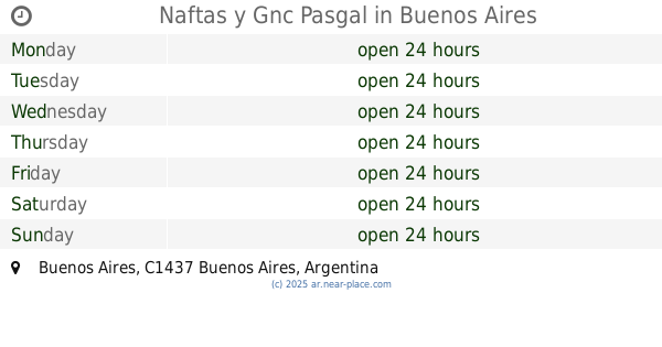
Avenida Amancio Alcorta 3165
Gas station
read more
717 m
Naftas y Gnc Pasgal
Gas station
read more
718 m
Estacion de Servicio Pasgal
Atuel 1093
Gas station
read more
803 m
YPF
Avenida Amancio Alcorta 2711, Buenos Aires
Gas station
read more
857 m
Gasolineria Ferrari
Lynch 3401-3499, C1437HOA
Gas station
read more
872 m
YPF Service Station
Avenida Amancio Alcorta 3415, Buenos Aires
Gas station
read more
872 m
YPF
Avenida Amancio Alcorta 3415, Buenos Aires
Gas station
read more
891 m
Gnc Pompeya
Avenida Amancio Alcorta 3419
Gas station
read more
1.006 km
Shell
3702, Avenida Chiclana
Gas station
read more
1.072 km
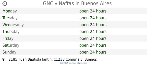
GNC y Naftas
Juan Bautista Jantin 2185
Gas station
read more
1.079 km
Chiclana 3827 SRL
Avenida Chiclana 3827
Gas station
read more
1.079 km
Chiclana 3827 SRL
Av Chiclana 3827
Gas station
read more
1.47 km
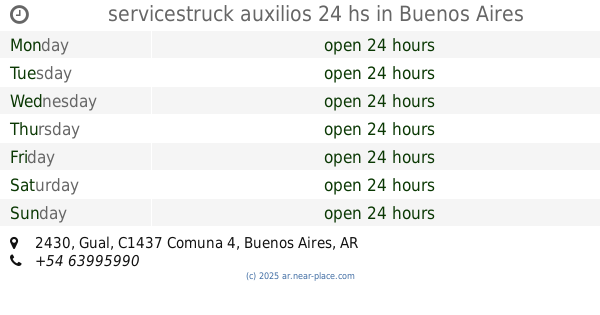
servicestruck auxilios 24 hs
Gual 2430
Gas station
read more
1.719 km
YPF Velez Sarsfield
Avenida Vélez Sarsfield 901
Gas station
read more
1.729 km
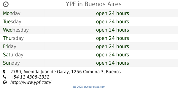
YPF
Avenida dr velez sarsfield 850
Gas station
read more
1.734 km
YPF
Avenida Juan de Garay 2780, Buenos Aires
Gas station
read more
2.333 km
Naftas y Gnc Ambest
Gas station
read more
📑
all categories
Accounting
Administrative area level 1
Administrative area level 2
Airport
Amusement park
Aquarium
Art gallery
Atm
Bakery
Bank
Bar
Beauty salon
Bicycle store
Book store
Bowling alley
Bus station
Cafe
Campground
Car dealer
Car rental
Car repair
Car wash
Casino
Cemetery
Church
City hall
Clothing store
Colloquial area
Convenience store
Country
Courthouse
Dentist
Department store
Doctor
Electrician
Electronics store
Embassy
Establishment
Finance
Fire station
Florist
Food
Funeral home
Furniture store
Gas station
General contractor
Grocery or supermarket
Gym
Hair care
Hardware store
Health
Hindu Temple
Home goods store
Hospital
Insurance agency
Intersection
Jewelry store
Laundry
Lawyer
Library
Light rail station
Liquor store
Local government office
Locality
Locksmith
Lodging
Meal delivery
Meal takeaway
Mosque
Movie rental
Movie theater
Moving company
Museum
Natural feature
Neighborhood
Night club
Painter
Park
Parking
Pet store
Pharmacy
Physiotherapist
Place of worship
Plumber
Point of interest
Police
Political
Post office
Premise
Real estate agency
Restaurant
Roofing contractor
Route
Rv park, camping
School
Shoe store
Shopping mall
Spa
Stadium
Storage
Store
Subpremise
Subway station
Supermarket
Synagogue
Taxi stand
Train station
Transit station
Travel agency
University
Veterinary care
Zoo
sublocality level 1
sublocality level 3
↑