Bakery nearby La nueva Argentina
Argentina
Bakery nearby La nueva Argentina
La nueva Argentina
851, Soldado de la Independencia, 1426, Comuna 14, Buenos Aires, AR Argentina
contacts phone
:
+54 11 5197-5134
website:
www.instagram.com
Latitude:
-34.566887
, Longitude:
-58.435518
larger map & directions
read more
nearest Bakery
100 m
Hausbrot
Maure 1771
Bakery
read more
214 m
Panadería Bellaria
Teniente Benjamín Matienzo 1744
Bakery
read more
228 m
Tatú Empanadas Salteñas
Soldado de la Independencia 1023
Bakery
read more
269 m
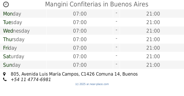
Mangini Confiterias
Avenida Luis María Campos 805
Bakery
read more
284 m
Manggini Panadería
Avenida Luis María Campos 799, C1426BOD
Bakery
read more
291 m
El Artesano Confiteria
Báez 709
Bakery
read more
347 m
San Rafael
Teniente Benjamín Matienzo 1987
Bakery
read more
347 m
La Nueva Modelo
Teniente Benjamín Matienzo 1987
Bakery
read more
359 m
Panfe S.R.L.
Teniente Benjamín Matienzo 1987
Bakery
read more
362 m
Le Ble
Avenida del Libertador 4502
Bakery
read more
413 m
Agalma Cakes
República de Eslovenia 1917
Bakery
read more
415 m
Mamía
Soldado de la Independencia 1177
Bakery
read more
445 m
Buenos Aires Bakery
C1426BSH, Arce 502
Bakery
read more
520 m
Tartas Crams
Avenida Luis María Campos 1226, C1426BOX
Bakery
read more
729 m
Bakery Buenos Aires
Avenida Federico Lacroze 2239
Bakery
read more
787 m
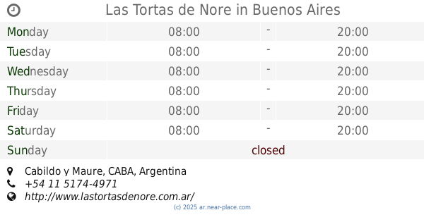
Las Tortas de Nore
Cabildo y Maure, Buenos Aires
Bakery
read more
823 m
Mamma Shule
Soldado de la Independencia 1486
Bakery
read more
824 m
Despacho de Pan Santos Dumunt
Santos Dumont 2443
Bakery
read more
841 m
Itatí
Avenida Luis María Campos 1487
Bakery
read more
911 m
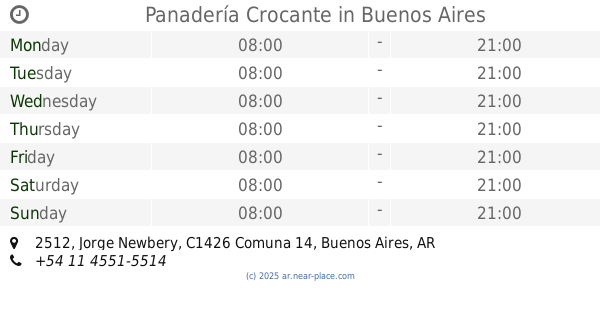
Panadería Crocante
Jorge Newbery 2512
Bakery
read more
1.002 km
Keka tortas
Ciudad de La Paz 267
Bakery
read more
1.043 km
Homebaker Colegiales
C1426AGL, Ciudad de La Paz 606
Bakery
read more
1.09 km
Apócrifo
Avenida Luis María Campos 92
Bakery
read more
1.136 km
Brûlée
Amenábar 612
Bakery
read more
1.217 km
Hausbrot
Jumbo Supermercado, Avenida Intendente Bullrich 345
Bakery
read more
📑
all categories
Accounting
Administrative area level 1
Administrative area level 2
Airport
Amusement park
Aquarium
Art gallery
Atm
Bakery
Bank
Bar
Beauty salon
Bicycle store
Book store
Bowling alley
Bus station
Cafe
Campground
Car dealer
Car rental
Car repair
Car wash
Casino
Cemetery
Church
City hall
Clothing store
Colloquial area
Convenience store
Country
Courthouse
Dentist
Department store
Doctor
Electrician
Electronics store
Embassy
Establishment
Finance
Fire station
Florist
Food
Funeral home
Furniture store
Gas station
General contractor
Grocery or supermarket
Gym
Hair care
Hardware store
Health
Hindu Temple
Home goods store
Hospital
Insurance agency
Intersection
Jewelry store
Laundry
Lawyer
Library
Light rail station
Liquor store
Local government office
Locality
Locksmith
Lodging
Meal delivery
Meal takeaway
Mosque
Movie rental
Movie theater
Moving company
Museum
Natural feature
Neighborhood
Night club
Painter
Park
Parking
Pet store
Pharmacy
Physiotherapist
Place of worship
Plumber
Point of interest
Police
Political
Post office
Premise
Real estate agency
Restaurant
Roofing contractor
Route
Rv park, camping
School
Shoe store
Shopping mall
Spa
Stadium
Storage
Store
Subpremise
Subway station
Supermarket
Synagogue
Taxi stand
Train station
Transit station
Travel agency
University
Veterinary care
Zoo
sublocality level 1
sublocality level 3
↑