Bar nearby Social Club
Argentina
Bar nearby Social Club
Social Club
1927, Avenida Juan de Garay, C1256, Comuna 3, Buenos Aires, AR Argentina
contacts phone
:
+54
Latitude:
-34.6272081
, Longitude:
-58.3925155
larger map & directions
read more
nearest Bar
389 m
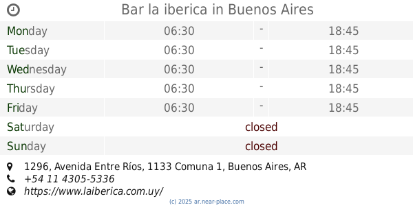
Bar la iberica
Avenida Entre Ríos 1296, Buenos Aires
Bar
read more
421 m
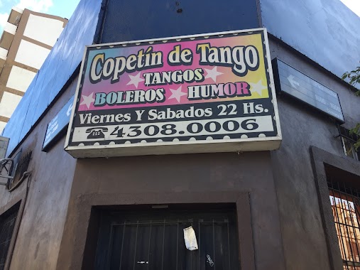
Copetín de Tango
Avenida Juan de Garay 2300
Bar
read more
481 m
Pulpería Flamingo
Combate de los Pozos 1964
Bar
read more
504 m
Santa Lucía
Avenida San Juan 1899
Bar
read more
507 m
Rotisería Miramar
Avenida San Juan 1999
Bar
read more
507 m
La Armonia Cafe Bar
15 de Noviembre de 1889 1799
Bar
read more
539 m
Food & Coffe
Avenida San Juan 1702
Bar
read more
549 m
Bravo Ana M
Pichincha 1880
Bar
read more
689 m
Z1 Panchos Crvezas
C1154AAW, Avenida Brasil 1363
Bar
read more
764 m
La Guarda
Presidente Luis Sáenz Peña 1974
Bar
read more
771 m
La nueva esquina
Carlos Calvo 1999
Bar
read more
773 m
Charly
Pavón 1299
Bar
read more
814 m
Bar Michi
Avenida Brasil 1300
Bar
read more
882 m
bar Victoria
O'Brien 1219
Bar
read more
898 m
Vente Paca
20, ADB, Santa Cruz
Bar
read more
904 m
Bar
C1151ABA, Pavón 1115
Bar
read more
916 m
Chupi Chupi Bar
Salta 1794
Bar
read more
990 m
King Sao
Avenida Independencia 1802
Bar
read more
996 m
Parrilla La Alegría
Pavón 2757
Bar
read more
998 m
Estación Quilmes Bar
C1137ABA, O'Brien 1157
Bar
read more
1.016 km
Pausa Restó Bar
Avenida Jujuy 1130
Bar
read more
1.021 km
Bar San José
San José 1000, Buenos Aires
Bar
read more
1.06 km
~MALU~ Pizza-Café
Carlos Calvo 2438
Bar
read more
1.161 km
Bar de Cao
Av. Independencia 2400
Bar
read more
1.21 km
Bar
C1075AAT, Santiago del Estero 910
Bar
read more
📑
all categories
Accounting
Administrative area level 1
Administrative area level 2
Airport
Amusement park
Aquarium
Art gallery
Atm
Bakery
Bank
Bar
Beauty salon
Bicycle store
Book store
Bowling alley
Bus station
Cafe
Campground
Car dealer
Car rental
Car repair
Car wash
Casino
Cemetery
Church
City hall
Clothing store
Colloquial area
Convenience store
Country
Courthouse
Dentist
Department store
Doctor
Electrician
Electronics store
Embassy
Establishment
Finance
Fire station
Florist
Food
Funeral home
Furniture store
Gas station
General contractor
Grocery or supermarket
Gym
Hair care
Hardware store
Health
Hindu Temple
Home goods store
Hospital
Insurance agency
Intersection
Jewelry store
Laundry
Lawyer
Library
Light rail station
Liquor store
Local government office
Locality
Locksmith
Lodging
Meal delivery
Meal takeaway
Mosque
Movie rental
Movie theater
Moving company
Museum
Natural feature
Neighborhood
Night club
Painter
Park
Parking
Pet store
Pharmacy
Physiotherapist
Place of worship
Plumber
Point of interest
Police
Political
Post office
Premise
Real estate agency
Restaurant
Roofing contractor
Route
Rv park, camping
School
Shoe store
Shopping mall
Spa
Stadium
Storage
Store
Subpremise
Subway station
Supermarket
Synagogue
Taxi stand
Train station
Transit station
Travel agency
University
Veterinary care
Zoo
sublocality level 1
sublocality level 3
↑