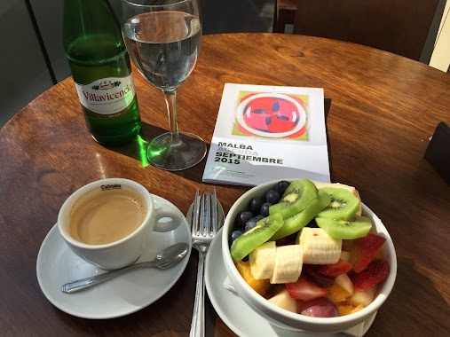
Cafe nearby Cafetero Paulino.
Argentina
Cafe nearby Cafetero Paulino.
Cafetero Paulino.
4511, Avenida Belisario Roldán, Comuna 14, Buenos Aires, AR Argentina
contacts phone
:
+54
Latitude:
-34.5683128
, Longitude:
-58.4122993
larger map & directions
read more
nearest Cafe
817 m
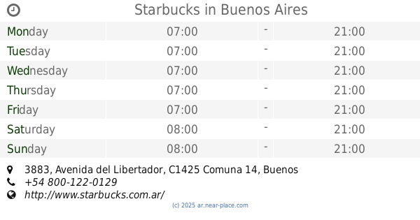
Starbucks
Avenida del Libertador 3883
Cafe
read more
818 m
Café Martínez
Avenida del Libertador 3598
Cafe
read more
974 m
Dia
Juan Francisco Seguí 4501-4579
Cafe
read more
1.02 km
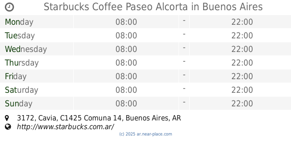
Starbucks Coffee Paseo Alcorta
Cavia 3172
Cafe
read more
1.027 km
Maxikiosco Oro
Fray Justo Santa María de Oro 2933, Buenos Aires
Cafe
read more
1.036 km
Il Mercado di Cavia
3090, DDD, Cavia C1425DDD, Buenos Aires
Cafe
read more
1.036 km
Il Mercado di Cavia
Cavia 3090, C1425DDD
Cafe
read more
1.048 km
Chips Café
Alcorta Shopping, Jerónimo Salguero 3172
Cafe
read more
1.052 km
Un altra VOLTA
Carrefour Salguero, Jerónimo Salguero 3112
Cafe
read more
1.055 km
Havanna
Paseo Alcorta, Jerónimo Salguero 3172
Cafe
read more
1.061 km
Starbucks
Jerónimo Salguero 3172
Cafe
read more
1.102 km
QUMACATERING
Sinclair 3165, BOTANICO
Cafe
read more
1.102 km
Catering y Pastelería Quma
Sinclair 3165, BOTANICO
Cafe
read more
1.115 km
Nucha
Avenida Cerviño 4403
Cafe
read more
1.24 km
Marcelo Dolce Cafe Malba
C1425CLA, Avenida Presidente Figueroa Alcorta 3401-3499
Cafe
read more
1.255 km
Cafe des Arts
Avenida Presidente Figueroa Alcorta 3415
Cafe
read more
1.303 km
Coco Café
C1425APP, Cabello 3794, Buenos Aires
Cafe
read more
1.38 km
Tienda De Cafe
Cafe
read more
1.846 km
Los Molinos Confitería
C1425ASG, Avenida General Las Heras 2991
Cafe
read more
1.934 km
Decata
Soldado de la Independencia 670
Cafe
read more
1.99 km
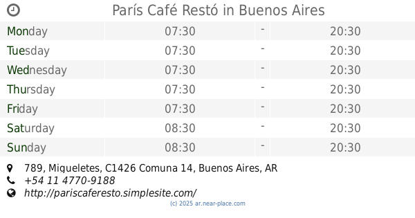
París Café Restó
Migueletes 789
Cafe
read more
2.101 km
El Club del Té | Academia de té, catas y eventos corporativos
AOA, José León Pagano 2653
Cafe
read more
2.106 km
Whoopies
C1425EZF, Charcas 4006
Cafe
read more
2.12 km
TAKEAWAY
Paraguay 4477
Cafe
read more
2.57 km
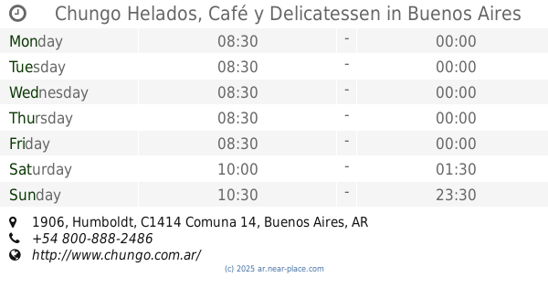
Chungo Helados, Café y Delicatessen
Humboldt 1906
Cafe
read more
📑
all categories
Accounting
Administrative area level 1
Administrative area level 2
Airport
Amusement park
Aquarium
Art gallery
Atm
Bakery
Bank
Bar
Beauty salon
Bicycle store
Book store
Bowling alley
Bus station
Cafe
Campground
Car dealer
Car rental
Car repair
Car wash
Casino
Cemetery
Church
City hall
Clothing store
Colloquial area
Convenience store
Country
Courthouse
Dentist
Department store
Doctor
Electrician
Electronics store
Embassy
Establishment
Finance
Fire station
Florist
Food
Funeral home
Furniture store
Gas station
General contractor
Grocery or supermarket
Gym
Hair care
Hardware store
Health
Hindu Temple
Home goods store
Hospital
Insurance agency
Intersection
Jewelry store
Laundry
Lawyer
Library
Light rail station
Liquor store
Local government office
Locality
Locksmith
Lodging
Meal delivery
Meal takeaway
Mosque
Movie rental
Movie theater
Moving company
Museum
Natural feature
Neighborhood
Night club
Painter
Park
Parking
Pet store
Pharmacy
Physiotherapist
Place of worship
Plumber
Point of interest
Police
Political
Post office
Premise
Real estate agency
Restaurant
Roofing contractor
Route
Rv park, camping
School
Shoe store
Shopping mall
Spa
Stadium
Storage
Store
Subpremise
Subway station
Supermarket
Synagogue
Taxi stand
Train station
Transit station
Travel agency
University
Veterinary care
Zoo
sublocality level 1
sublocality level 3
↑