Cafe nearby Starbucks
Argentina
Cafe nearby Starbucks
Starbucks
3883, Avenida del Libertador, C1425, Comuna 14, Buenos Aires, AR Argentina
contacts phone
:
+54 800-122-0129
website:
www.starbucks.com.ar
Latitude:
-34.5698703
, Longitude:
-58.4210187
larger map & directions
read more
nearest Cafe
252 m
Muu Lecheria
Armenia, palermo
Cafe
read more
388 m
Café Martínez
Avenida del Libertador 3598
Cafe
read more
428 m
Catering y Pastelería Quma
Sinclair 3165, BOTANICO
Cafe
read more
428 m
QUMACATERING
Sinclair 3165, BOTANICO
Cafe
read more
434 m
Dia
Juan Francisco Seguí 4501-4579
Cafe
read more
548 m
Maxikiosco Oro
Fray Justo Santa María de Oro 2933, Buenos Aires
Cafe
read more
586 m
Tea Connection
Sinclair 3027
Cafe
read more
657 m
Gourmet Service SRL
Cafe
read more
682 m
Starbucks
A. Intendente Bullrich 345, Buenos Aires
Cafe
read more
684 m
Nucha
Avenida Cerviño 4403
Cafe
read more
802 m
Delicity
Godoy Cruz 2905
Cafe
read more
807 m
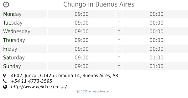
Chungo
Juncal 4602
Cafe
read more
817 m
Cafetero Paulino.
Avenida Belisario Roldán 4511
Cafe
read more
845 m
Quinpe Café & Cosas Ricas
Fray Justo Santa Maria de Oro 2701 Y Juncal 4499
Cafe
read more
857 m
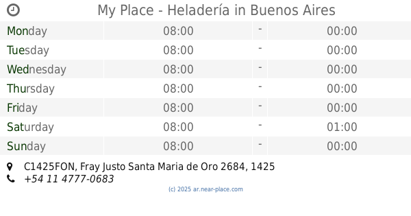
My Place - Heladería
C1425FON, Fray Justo Santa Maria de Oro 2684
Cafe
read more
917 m
Cremolatti
4599 C1425BDC, Antonio Beruti 4583
Cafe
read more
949 m
The Coffee Store Charcas
Cafe
read more
958 m
Piccolo Caffe
Arce 399, C1426BSC
Cafe
read more
969 m
Tonno
Arce 401
Cafe
read more
980 m
Café Martínez
Ortega y Gasset 1693
Cafe
read more
1.016 km
Le Blé
Avenida del Libertador 4501, C1426BWG
Cafe
read more
1.087 km
Vivi Sabores Colombia
Humboldt 2496
Cafe
read more
1.175 km
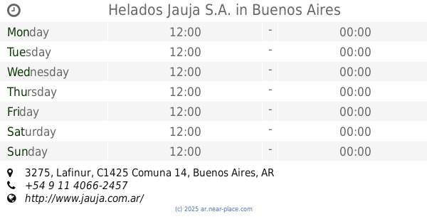
Helados Jauja S.A.
Lafinur 3275
Cafe
read more
1.213 km
Bella Italia Café & Bar
República Arabe Siria 3330
Cafe
read more
1.809 km
Garage
Arévalo 1985
Cafe
read more
📑
all categories
Accounting
Administrative area level 1
Administrative area level 2
Airport
Amusement park
Aquarium
Art gallery
Atm
Bakery
Bank
Bar
Beauty salon
Bicycle store
Book store
Bowling alley
Bus station
Cafe
Campground
Car dealer
Car rental
Car repair
Car wash
Casino
Cemetery
Church
City hall
Clothing store
Colloquial area
Convenience store
Country
Courthouse
Dentist
Department store
Doctor
Electrician
Electronics store
Embassy
Establishment
Finance
Fire station
Florist
Food
Funeral home
Furniture store
Gas station
General contractor
Grocery or supermarket
Gym
Hair care
Hardware store
Health
Hindu Temple
Home goods store
Hospital
Insurance agency
Intersection
Jewelry store
Laundry
Lawyer
Library
Light rail station
Liquor store
Local government office
Locality
Locksmith
Lodging
Meal delivery
Meal takeaway
Mosque
Movie rental
Movie theater
Moving company
Museum
Natural feature
Neighborhood
Night club
Painter
Park
Parking
Pet store
Pharmacy
Physiotherapist
Place of worship
Plumber
Point of interest
Police
Political
Post office
Premise
Real estate agency
Restaurant
Roofing contractor
Route
Rv park, camping
School
Shoe store
Shopping mall
Spa
Stadium
Storage
Store
Subpremise
Subway station
Supermarket
Synagogue
Taxi stand
Train station
Transit station
Travel agency
University
Veterinary care
Zoo
sublocality level 1
sublocality level 3
↑